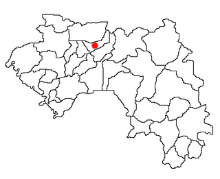
Koubia is a prefecture located in the Labé Region of Guinea in the Fouta Djallon mountains. Fulas are the majority ethnic group in the region with Fula (Pular) as the primary language. The capital is Koubia. The prefecture covers an area of 2,800 km.² and has an estimated population of 114,000.

Dantewada is a town and a nagar palika in the Dantewada district in the state of Chhattisgarh, India. It is the administrative headquarters of Dantewada District. It is the fourth largest city of Bastar division.
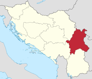
The Morava Banovina or Morava Banate, was a province (banovina) of the Kingdom of Yugoslavia between 1929 and 1941. This province consisted of parts of present-day Central Serbia and it was named for the Morava Rivers. The capital city of the Morava Banovina was Niš.

IVC 2 inch Helical scan was a high-end broadcast quality helical scan analog recording VTR format developed by International Video Corporation (IVC), and introduced in 1975. Previously, IVC had made a number of 1 inch Helical VTRs. IVC saw a chance to make a VTR that would have the quality of the then-standard 2 inch Quadruplex videotape format but with the advantages of helical scan. They then developed a VTR using this technology, the IVC Model 9000.

Osiek is a village in the administrative district of Gmina Oława, within Oława County, Lower Silesian Voivodeship, in south-western Poland. Prior to 1945 it was in Germany. It lies approximately 4 kilometres (2 mi) south of Oława and 32 km (20 mi) south-east of the regional capital Wrocław.
Łabędź is a village in the administrative district of Gmina Wąbrzeźno, within Wąbrzeźno County, Kuyavian-Pomeranian Voivodeship, in north-central Poland. It lies approximately 4 kilometres (2 mi) north-west of Wąbrzeźno and 36 km (22 mi) north-east of Toruń.
Narutowo is a village in the administrative district of Gmina Skępe, within Lipno County, Kuyavian-Pomeranian Voivodeship, in north-central Poland. It lies approximately 5 kilometres (3 mi) north-west of Skępe, 11 km (7 mi) north-east of Lipno, and 49 km (30 mi) east of Toruń.
Kaniuki is a village in the administrative district of Gmina Zabłudów, within Białystok County, Podlaskie Voivodeship, in north-eastern Poland. It lies approximately 14 kilometres (9 mi) south of Zabłudów and 26 km (16 mi) south of the regional capital Białystok.
Podgórz is a village in the administrative district of Gmina Wilków, within Opole Lubelskie County, Lublin Voivodeship, in eastern Poland. It lies approximately 5 kilometres (3 mi) north-east of Wilków, 18 km (11 mi) north of Opole Lubelskie, and 48 km (30 mi) west of the regional capital Lublin.
The VAXserver was a family of minicomputers developed and manufactured by Digital Equipment Corporation (DEC) using processors implementing the VAX instruction set architecture (ISA). The VAXserver models were variants of various VAX-based computers which were configured to only run operating systems which were licensed for network server use and not interactive time-sharing use. This was accomplished with different CPU modules and firmware.
Bolesławów is a village in the administrative district of Gmina Borek Wielkopolski, within Gostyń County, Greater Poland Voivodeship, in west-central Poland. It lies approximately 4 kilometres (2 mi) south-east of Borek Wielkopolski, 20 km (12 mi) east of Gostyń, and 62 km (39 mi) south-east of the regional capital Poznań.
Kobylata is a village in the administrative district of Gmina Kłodawa, within Koło County, Greater Poland Voivodeship, in west-central Poland. It lies approximately 6 kilometres (4 mi) north of Kłodawa, 22 km (14 mi) north-east of Koło, and 136 km (85 mi) east of the regional capital Poznań.
Koty is a village in the administrative district of Gmina Lidzbark, within Działdowo County, Warmian-Masurian Voivodeship, in northern Poland. It lies approximately 7 kilometres (4 mi) north-east of Lidzbark, 21 km (13 mi) west of Działdowo, and 67 km (42 mi) south-west of the regional capital Olsztyn.
Notyst Mały is a village in the administrative district of Gmina Mrągowo, within Mrągowo County, Warmian-Masurian Voivodeship, in northern Poland. It lies approximately 11 kilometres (7 mi) east of Mrągowo and 64 km (40 mi) east of the regional capital Olsztyn.
Polska Wieś is a village in the administrative district of Gmina Mrągowo, within Mrągowo County, Warmian-Masurian Voivodeship, in northern Poland. It lies approximately 4 kilometres (2 mi) north of Mrągowo and 55 km (34 mi) east of the regional capital Olsztyn.
Huépac Municipality is a municipality in Sonora in north-western Mexico.
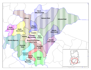
The Sekyere Afram Plains District is one of the twenty-seven (27) districts in the Ashanti Region of Ghana. Its capital is Kumawu. The district is among the new districts and municipalities created in 2008 by the then President, John Kufuor.
Cañas Gordas is a corregimiento in Renacimiento District, Chiriquí Province, Panama. It has a land area of 60.8 square kilometres (23.5 sq mi) and had a population of 3,090 as of 2010, giving it a population density of 50.8 inhabitants per square kilometre (132/sq mi). Its population as of 1990 was 2,448; its population as of 2000 was 2,682.
Campana is a corregimiento in Capira District, Panamá Oeste Province, Panama with a population of 2,067 as of 2010. Its population as of 1990 was 1,363; its population as of 2000 was 1,692.
San Juan is a corregimiento in San Francisco District, Veraguas Province, Panama with a population of 1,591 as of 2010. Its population as of 1990 was 3,797; its population as of 2000 was 4,028.


