For the town in India, see Ziro.
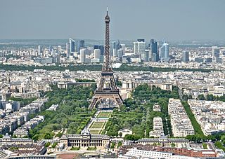
The Île-de-France is the most populous of the eighteen regions of France, with an official estimated population of 12,271,794 residents on 1 January 2023. Centred on the capital Paris, it is located in the north-central part of the country and often called the Paris Region. Île-de-France is densely populated and retains a prime economic position on the national stage, but it covers only 12,012 square kilometres, about 2% of metropolitan French territory. Its 2017 population was nearly one-fifth of the national total.

Haut-Ogooué is the southeasternmost of Gabon's nine provinces. It is named after the Ogooué River. It covers an area of 36,547 km2 (14,111 sq mi). The provincial capital is Franceville. One of its primary industries is mining, with manganese, gold and uranium being found in the region. The uranium-bearing mineral francevillite takes its name from the primary city. It is the historical home of three cultures, the Obamba, Ndzebi and Téké. Like many regions in Africa, more traditional uses of the land have given way to rural migration to the larger cities. In August 2006, its soccer club won the Gabon Independence Cup.

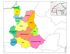
Houet is one of the 45 provinces of Burkina Faso, located in its Hauts-Bassins Region. The capital of Houet is Bobo-Dioulasso. In 2019, the province had a population of 1,509,377.

Kouritenga is one of the 45 provinces of Burkina Faso, located in its Centre-Est Region. In 2019, the province had a population of 479,930. Its capital is Koupéla.

La Teste-de-Buch is a coastal commune in the Gironde department in the Nouvelle-Aquitaine region in Southwestern France. Until 13 June 1994, it was officially known simply as La Teste.
Lorette is a commune in the Loire department in central France, in the Gier valley.
Akoubounou, or Akabinu in the local Tin Sert language, is a village located in the west to the town of Abalak, in the Tahoua Region of Niger.
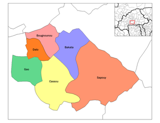
Cassou is a department or commune of Ziro Province in southern Burkina Faso. The capital is Cassou. The population of the department was 40,833 in 2006.
Bama is a village in the Solenzo Department of Banwa Province in western Burkina Faso. As of 2005 it had a population of 1,080.

Tominian Cercle is an administrative subdivision of the Ségou Region of Mali. The administrative center of the local government is in the town of Tominian. The Cercle is divided into Communes, and below this, quarters/villages. In the 2009 census the cercle had a population of 219,853 people.

Mopti Cercle is an administrative subdivision of the Mopti Region of Mali. The administrative center (chef-lieu) is the town of Mopti.

Timbuktu Cercle is an administrative subdivision of the Tombouctou Region of Mali. It is the largest cercle by area in the whole of Mali. The capital lies at the city of Timbuktu. The cercle is divided into rural and urban communes, and below this, quarters/villages. In the 2009 census the cercle had a population of 124,546.
Tamaske is a city and rural commune in Niger. It is located in the Keita Department, in the Tahoua Region.
Yaouri is a village and rural commune in Matameye Department in Niger.
Gnémasson is a town and arrondissement in the Atakora Department of northwestern Benin. It is an administrative division under the jurisdiction of the commune of Péhunco. According to the population census conducted by the Institut National de la Statistique Benin on February 15, 2002, the arrondissement had a total population of 11,069.
Bona is a village in Lena Department, Houet Province, Burkina Faso.
Belembaoghin, also spelt Belembaghin, Belmbaghin or Bélembaoguen, is a commune in the Gounghin Department of Kouritenga Province in the Centre-Est region of Burkina Faso. It had a population of 522 in 2006.
Belemboulghin, also spelt Belemboulgui, is a commune in the Gounghin Department of Kouritenga Province in the Centre-Est region of Burkina Faso. It had a population of 1,350 in 2006.

Padéma, sometimes also named Badéma or Badéna, is a department or commune of Houet Province in Hauts-Bassins Region, Burkina Faso.