

The Lô River (Vietnamese : Sông Lô) is a major river of Vietnam. It flows through Hà Giang Province, Tuyên Quang Province and Phú Thọ Province for 470 kilometres and has a basin area of 39,000 km2 and originates in Yunnan, China. [1]


The Lô River (Vietnamese : Sông Lô) is a major river of Vietnam. It flows through Hà Giang Province, Tuyên Quang Province and Phú Thọ Province for 470 kilometres and has a basin area of 39,000 km2 and originates in Yunnan, China. [1]
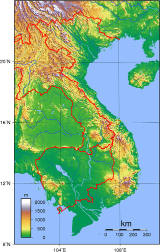
Vietnam is located on the eastern margin of the Indochinese peninsula and occupies about 331,211.6 square kilometres (127,881.5 sq mi), of which about 25% was under cultivation in 1987. It borders the Gulf of Tonkin, Gulf of Thailand, and Pacific Ocean, along with China, Laos, and Cambodia. The elongated roughly S shaped country has a north-to-south distance of 1,650 km (1,030 mi) and is about 50 km (31 mi) wide at the narrowest point. With a coastline of 3,260 km (2,030 mi), excluding islands, Vietnam claims 12 nautical miles as the limit of its territorial waters, an additional 12 nautical miles as a contiguous customs and security zone. It has an exclusive economic zone of 417,663 km2 (161,261 sq mi) with 200 nautical miles.

The Red River, also known as the Hong River and Sông Cái in Vietnamese, and the Yuan River in Chinese, is a 1,149-kilometer (714 mi)-long river that flows from Yunnan in Southwest China through northern Vietnam to the Gulf of Tonkin. According to C. Michael Hogan, the associated Red River Fault was instrumental in forming the entire South China Sea at least as early as 37 million years before present. The name red and southern position in China are associated in traditional cardinal directions. The river is relatively shallow, and carries a lot of reddish silt along its way, appearing red brown in colour.

The Black River, also known upstream as the Lixian River in China, is a river located in China and northwestern Vietnam.
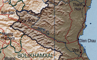
The Cả River or better known as Lam River is a river in mainland Southeast Asia.

Việt Trì (越池) is the capital city of Phú Thọ Province in the Northeast region of Vietnam. In 2010, the city had a population of 260,288. The city covers an area of 110 square kilometres (42 sq mi). Việt Trì is also the economic centre of the province and contains many industrial firms and service industries.

The Red River Delta or Hong River Delta is the flat low-lying plain formed by the Red River and its distributaries merging with the Thái Bình River in northern Vietnam. Hồng (紅) is a Sino-Vietnamese word for "red" or "crimson". The delta has the smallest area but highest population and population density of all regions. The region, measuring some 15,000 square kilometres (6,000 sq mi) is well protected by a network of dikes. It is an agriculturally rich and densely populated area. Most of the land is devoted to rice cultivation.

Ba Bể National Park is a reserve in Bắc Kạn Province, Northeast region of Vietnam, set up to protect a very murky lake along with surrounding limestone and highland nevergreen forests. It is located about 240 kilometers northwest of the capital city Hanoi.

Đông Bắc is the region to the north of the Red River Delta in Vietnam, bordering China. It is called Northeast to distinguish it from the Tây Bắc or "Northwest", but it is actually in the north and northeast of Hanoi, wider than Việt Bắc or "Northern Vietnam". The Northeast is one of three sub-regions of Northern Vietnam. Sometimes the Northeast includes the Red River Delta.

Phú Tân is a rural district (huyện) of An Giang province in the Mekong Delta region of Vietnam. As of 2019 the district had a population of 188,951. The district covers an area of 307 km². The district capital lies at Phú Mỹ.

Thuận Thành is a district-level town of Bắc Ninh province in the Red River Delta region of Vietnam. As of 2022 the town had a population of 199,577. The district covers an area of 117.83 km². The town seat lies at Hồ.
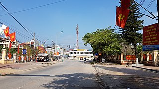
Khoái Châu is a rural district of Hưng Yên province in the Red River Delta region of Vietnam. In Sino-Vietnamese script, used until 1919, the name is given as 快州.

Bắc Kạn, sometimes misspelled as Bắc Cạn, is a province of Vietnam. It is located in the Northeast region, due north of the capital Hanoi.

Tuyên Quang is a province of Vietnam, located in the northeastern part of the country to the northwest of Hanoi, at the centre of Lô River valley, a tributary of the Red River. Its capital is Tuyên Quang. The province had a population of 784,811 in 2019, with a density of 130 persons per km2 over a total land area of 5,867.3 square kilometres (2,265.4 sq mi).
The Nho Quế River is a river of Vietnam and China. It flows through Hà Giang Province, Cao Bằng Province and China for 192 kilometres. The river has a basin area of 6052 square kilometres,
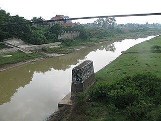
The Cà Lồ River is a river of Vietnam. It flows through Vĩnh Phúc Province, Hanoi and Bắc Ninh Province for 89 kilometres and has a basin area of 880 km².
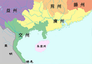
Jiaozhou was an imperial Chinese province under the Han and Jin dynasties. Under the Han, the area included Liangguang and northern Vietnam but Guangdong was later separated to form the province of Guangzhou by Sun Quan following the death of Shi Xie and lasted until the creation of the Annan Protectorate in 679.

The Gâm River is a river which derived from the Guangxi, China.

The Thạch Hãn River is a river in Quảng Trị province, Vietnam. It rises in the Annamite Mountains, and enters the South China Sea east of Đông Hà. It is approximately 270 kilometres (170 mi) long, with two main tributaries and with several branches to the sea.

Chishui River is a major tributary of the upper Yangtze. Its name literally means "red water river"/"red river" because it shows reddish color in lower stream due to a large sediment concentration. With the source in Yunnan Province, it forms part of the boundary between the provinces of Guizhou and Sichuan and flows into Yangtze River in Sichuan. It is sometimes called the River of Wines since there are several types of famous Chinese wines, including Lang Wine, Xi Wine and Maotai, originated along the river. It is also known as the field of a major battle commanded by Mao Zedong in 1935 during the Long March of Red Army. The Jiming Three Provinces Bridge is being built where 3 provinces of Sichuan, Guizhou, and Yunnan meet.

Thao River is the upper stretch of the Red River, originates from Weishan Yi and Hui Autonomous County, Yunnan Province, China, flows through three Vietnamese provinces, including Lao Cai Province, Yen Bai Province and Phu Tho Province. Thao River merges with Black River and Lo River at Viet Tri City, Phu Tho Province, Vietnam.
21°18′N105°26′E / 21.300°N 105.433°E