Babin is a village in the administrative district of Gmina Strzałkowo, within Słupca County, Greater Poland Voivodeship, in west-central Poland. It lies approximately 5 kilometres (3 mi) north-east of Strzałkowo, 4 km (2 mi) north of Słupca, and 66 km (41 mi) east of the regional capital Poznań.
Brudzewo is a village in the administrative district of Gmina Strzałkowo, within Słupca County, Greater Poland Voivodeship, in west-central Poland. It lies approximately 6 kilometres (4 mi) north-west of Strzałkowo, 9 km (6 mi) north-west of Słupca, and 59 km (37 mi) east of the regional capital Poznań.
Ciosna is a village in the administrative district of Gmina Strzałkowo, within Słupca County, Greater Poland Voivodeship, in west-central Poland. It lies approximately 7 kilometres (4 mi) north-east of Strzałkowo, 6 km (4 mi) north of Słupca, and 67 km (42 mi) east of the regional capital Poznań.
Góry is a village in the administrative district of Gmina Strzałkowo, within Słupca County, Greater Poland Voivodeship, in west-central Poland. It lies approximately 8 kilometres (5 mi) north-west of Strzałkowo, 12 km (7 mi) north-west of Słupca, and 57 km (35 mi) east of the regional capital Poznań.
Graboszewo is a village in the administrative district of Gmina Strzałkowo, within Słupca County, Greater Poland Voivodeship, in west-central Poland. It lies approximately 7 kilometres (4 mi) south-west of Strzałkowo, 9 km (6 mi) south-west of Słupca, and 59 km (37 mi) east of the regional capital Poznań.
Janowo-Cegielnia is a settlement in the administrative district of Gmina Strzałkowo, within Słupca County, Greater Poland Voivodeship, in west-central Poland. It lies approximately 7 kilometres (4 mi) north of Strzałkowo, 9 km (6 mi) north-west of Słupca, and 62 km (39 mi) east of the regional capital Poznań.
Kokczyn Drugi is a village in the administrative district of Gmina Strzałkowo, within Słupca County, Greater Poland Voivodeship, in west-central Poland. It lies approximately 8 kilometres (5 mi) north of Strzałkowo, 10 km (6 mi) north-west of Słupca, and 59 km (37 mi) east of the regional capital Poznań.
Kokczyn Pierwszy is a village in the administrative district of Gmina Strzałkowo, within Słupca County, Greater Poland Voivodeship, in west-central Poland. It lies approximately 4 kilometres (2 mi) north-west of Strzałkowo, 7 km (4 mi) north-west of Słupca, and 60 km (37 mi) east of the regional capital Poznań.
Paruszewo is a village in the administrative district of Gmina Strzałkowo, within Słupca County, Greater Poland Voivodeship, in west-central Poland. It lies approximately 4 kilometres (2 mi) south-west of Strzałkowo, 6 km (4 mi) west of Słupca, and 61 km (38 mi) east of the regional capital Poznań.
Podkornaty is a village in the administrative district of Gmina Strzałkowo, within Słupca County, Greater Poland Voivodeship, in west-central Poland. It lies approximately 4 kilometres (2 mi) north of Strzałkowo, 6 km (4 mi) north-west of Słupca, and 61 km (38 mi) east of the regional capital Poznań.
Pospólno is a village in the administrative district of Gmina Strzałkowo, within Słupca County, Greater Poland Voivodeship, in west-central Poland. It lies approximately 2 kilometres (1 mi) north of Strzałkowo, 5 km (3 mi) north-west of Słupca, and 62 km (39 mi) east of the regional capital Poznań.
Rudy is a village in the administrative district of Gmina Strzałkowo, within Słupca County, Greater Poland Voivodeship, in west-central Poland. It lies approximately 7 kilometres (4 mi) north of Strzałkowo, 9 km (6 mi) north-west of Słupca, and 61 km (38 mi) east of the regional capital Poznań.
Skąpe is a village in the administrative district of Gmina Strzałkowo, within Słupca County, Greater Poland Voivodeship, in west-central Poland. It lies approximately 7 kilometres (4 mi) north of Strzałkowo, 8 km (5 mi) north of Słupca, and 63 km (39 mi) east of the regional capital Poznań.
Skarboszewo is a village in the administrative district of Gmina Strzałkowo, within Słupca County, Greater Poland Voivodeship, in west-central Poland. It lies approximately 5 kilometres (3 mi) south of Strzałkowo, 6 km (4 mi) south-west of Słupca, and 63 km (39 mi) east of the regional capital Poznań.
Staw II is a village in the administrative district of Gmina Strzałkowo, within Słupca County, Greater Poland Voivodeship, in west-central Poland. It lies approximately 5 kilometres (3 mi) north-west of Strzałkowo, 9 km (6 mi) north-west of Słupca, and 58 km (36 mi) east of the regional capital Poznań.
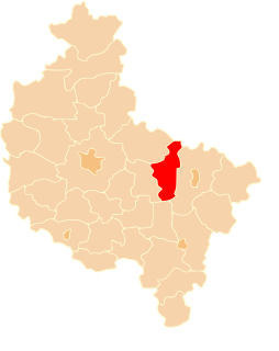
Strzałkowo is a village in Słupca County, Greater Poland Voivodeship, in west-central Poland. It is the seat of the gmina called Gmina Strzałkowo. It lies approximately 4 kilometres (2 mi) west of Słupca and 63 km (39 mi) east of the regional capital Poznań.
Szemborowo is a village in the administrative district of Gmina Strzałkowo, within Słupca County, Greater Poland Voivodeship, in west-central Poland. It lies approximately 10 kilometres (6 mi) north-west of Strzałkowo, 13 km (8 mi) north-west of Słupca, and 55 km (34 mi) east of the regional capital Poznań.
Unia is a village in the administrative district of Gmina Strzałkowo, within Słupca County, Greater Poland Voivodeship, in west-central Poland. It lies approximately 5 kilometres (3 mi) west of Strzałkowo, 8 km (5 mi) west of Słupca, and 58 km (36 mi) east of the regional capital Poznań.
Uścięcin is a settlement in the administrative district of Gmina Strzałkowo, within Słupca County, Greater Poland Voivodeship, in west-central Poland. It lies approximately 7 kilometres (4 mi) south-west of Strzałkowo, 10 km (6 mi) west of Słupca, and 58 km (36 mi) east of the regional capital Poznań.
Wólka is a village in the administrative district of Gmina Strzałkowo, within Słupca County, Greater Poland Voivodeship, in west-central Poland. It lies approximately 3 kilometres (2 mi) west of Strzałkowo, 6 km (4 mi) west of Słupca, and 60 km (37 mi) east of the regional capital Poznań.