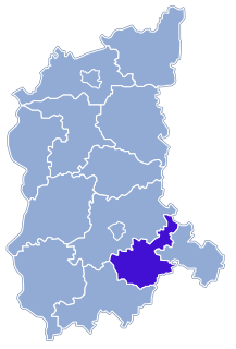
Nowa Sól County is a unit of territorial administration and local government (powiat) in Lubusz Voivodeship, western Poland. It came into being on January 1, 1999, as a result of the Polish local government reforms passed in 1998. Its administrative seat and largest town is Nowa Sól, which lies 22 km (14 mi) south-east of Zielona Góra and 109 km (68 mi) south of Gorzów Wielkopolski. The county contains three other towns: Kożuchów, lying 10 km (6 mi) south-west of Nowa Sól, Bytom Odrzański, lying 11 km (7 mi) south-east of Nowa Sól, and Nowe Miasteczko, 13 km (8 mi) south of Nowa Sól.

Kazimierzew is a village in the administrative district of Gmina Zadzim, within Poddębice County, Łódź Voivodeship, in central Poland. It lies approximately 1 kilometre (1 mi) south of Zadzim, 16 km (10 mi) south-west of Poddębice, and 43 km (27 mi) west of the regional capital Łódź.

Lgiń is a village in the administrative district of Gmina Wschowa, within Wschowa County, Lubusz Voivodeship, in western Poland. It lies approximately 10 kilometres (6 mi) north-west of Wschowa and 52 km (32 mi) east of Zielona Góra.
Pszczółkowo is a settlement in the administrative district of Gmina Wschowa, within Wschowa County, Lubusz Voivodeship, in western Poland. It lies approximately 10 kilometres (6 mi) west of Wschowa and 48 km (30 mi) east of Zielona Góra.
Dąb is a village in the administrative district of Gmina Sława, within Wschowa County, Lubusz Voivodeship, in western Poland. It lies approximately 6 kilometres (4 mi) north-west of Sława, 23 km (14 mi) north-west of Wschowa, and 36 km (22 mi) east of Zielona Góra.
Dębowo is a settlement in the administrative district of Gmina Sława, within Wschowa County, Lubusz Voivodeship, in western Poland. It lies approximately 6 kilometres (4 mi) north-west of Sława, 24 km (15 mi) north-west of Wschowa, and 36 km (22 mi) east of Zielona Góra.
Głuchów is a settlement in the administrative district of Gmina Sława, within Wschowa County, Lubusz Voivodeship, in western Poland. It lies approximately 6 kilometres (4 mi) south-west of Sława, 21 km (13 mi) west of Wschowa, and 37 km (23 mi) east of Zielona Góra.
Jutrzenka is a settlement in the administrative district of Gmina Sława, within Wschowa County, Lubusz Voivodeship, in western Poland. It lies approximately 4 kilometres (2 mi) south of Sława, 16 km (10 mi) west of Wschowa, and 42 km (26 mi) east of Zielona Góra.
Krążkowo is a village in the administrative district of Gmina Sława, within Wschowa County, Lubusz Voivodeship, in western Poland. It lies approximately 10 kilometres (6 mi) south of Sława, 17 km (11 mi) west of Wschowa, and 42 km (26 mi) east of Zielona Góra.
Łupice is a village in the administrative district of Gmina Sława, within Wschowa County, Lubusz Voivodeship, in western Poland. It lies approximately 10 kilometres (6 mi) north of Sława, 24 km (15 mi) north-west of Wschowa, and 41 km (25 mi) east of Zielona Góra.
Myszyniec is a settlement in the administrative district of Gmina Sława, within Wschowa County, Lubusz Voivodeship, in western Poland. It lies approximately 6 kilometres (4 mi) west of Sława, 23 km (14 mi) west of Wschowa, and 35 km (22 mi) east of Zielona Góra.
Dryżyna is a village in the administrative district of Gmina Szlichtyngowa, within Wschowa County, Lubusz Voivodeship, in western Poland. It lies approximately 3 kilometres (2 mi) east of Szlichtyngowa, 10 km (6 mi) south of Wschowa, and 59 km (37 mi) south-east of Zielona Góra.
Gola is a village in the administrative district of Gmina Szlichtyngowa, within Wschowa County, Lubusz Voivodeship, in western Poland. It lies approximately 5 kilometres (3 mi) north-west of Szlichtyngowa, 10 km (6 mi) south-west of Wschowa, and 53 km (33 mi) south-east of Zielona Góra.

Jędrzychowice is a village in the administrative district of Gmina Szlichtyngowa, within Wschowa County, Lubusz Voivodeship, in western Poland. It lies approximately 4 kilometres (2 mi) north-east of Szlichtyngowa, 8 km (5 mi) south of Wschowa, and 60 km (37 mi) south-east of Zielona Góra.
Kowalewo is a village in the administrative district of Gmina Szlichtyngowa, within Wschowa County, Lubusz Voivodeship, in western Poland. It lies approximately 5 kilometres (3 mi) east of Szlichtyngowa, 8 km (5 mi) south of Wschowa, and 61 km (38 mi) east of Zielona Góra.
Puszcza is a settlement in the administrative district of Gmina Szlichtyngowa, within Wschowa County, Lubusz Voivodeship, in western Poland. It lies approximately 1 kilometre (1 mi) north-west of Szlichtyngowa, 10 km (6 mi) south-west of Wschowa, and 57 km (35 mi) south-east of Zielona Góra.

Stare Drzewce is a village in the administrative district of Gmina Szlichtyngowa, within Wschowa County, Lubusz Voivodeship, in western Poland. It lies approximately 7 kilometres (4 mi) north-west of Szlichtyngowa, 7 km (4 mi) south-west of Wschowa, and 53 km (33 mi) east of Zielona Góra.
Zamysłów is a village in the administrative district of Gmina Szlichtyngowa, within Wschowa County, Lubusz Voivodeship, in western Poland. It lies approximately 3 kilometres (2 mi) north-west of Szlichtyngowa, 9 km (6 mi) south-west of Wschowa, and 56 km (35 mi) south-east of Zielona Góra.


