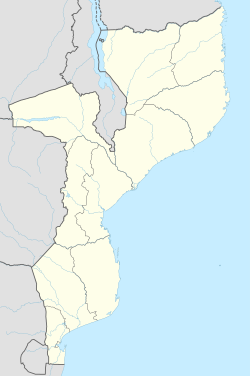
Mabalane | |
---|---|
Coordinates: 23°38′0″S32°31′0″E / 23.63333°S 32.51667°E Coordinates: 23°38′0″S32°31′0″E / 23.63333°S 32.51667°E | |
Country | |
Provinces | Maputo Province |
District | Moamba District |
Mabalane is a town in Mozambique located on the Limpopo River. There was a prison camp and garrison at Mabalane during the revolution.
Mabalane was affected by the floods that affected Mabalane District in February 1996. The flooding of the Limpopo saw the town and 12 villages partly submerged causing serious damage. [1]
It is served by a station on the southern main line of Mozambique Railways.
Zimbabwe is a landlocked country in southern Africa lying wholly within the tropics. It straddles an extensive high inland plateau that drops northwards to the Zambezi valley where the border with Zambia is and similarly drops southwards to the Limpopo valley and the border with South Africa. The country has borders with Botswana 813 km, Mozambique 1,231 km, South Africa 225 km, Zambia 797 km and almost meets Namibia at its westernmost point.
The Limpopo River rises in South Africa, and flows generally eastwards through Mozambique to the Indian Ocean. The term Limpopo is derived from Rivombo (Livombo/Lebombo), a group of Tsonga settlers led by Hosi Rivombo who settled in the mountainous vicinity and named the area after their leader. The river is approximately 1,750 kilometres (1,087 mi) long, with a drainage basin 415,000 square kilometres (160,200 sq mi) in size. The mean discharge measured over a year is 170 m3/s at its mouth. The Limpopo is the second largest river in Africa that drains to the Indian Ocean, after the Zambezi River.
Sofala is a province of Mozambique. It has a population of 2,259,248. Beira is the capital of the province, named for the ruined port of Sofala which is 35 kilometres (22 mi) to the south.
Gaza is a province of Mozambique. It has an area of 75,709 km2 and a population of 1,422,460.
The 2000 Mozambique flood was a natural disaster that occurred in February and March 2000. The catastrophic flooding was caused by heavy rainfall that lasted for five weeks and made many homeless. Approximately 700 people were killed. 1,400 km2 of arable land was affected and 20,000 head of cattle were lost. It was the worst flood in Mozambique in 50 years.
The Limpopo National Park was born when the status of Coutada 16 Wildlife Utilisation Area in Gaza Province, Mozambique, was changed from a hunting concession to a protected area. It forms part of the Great Limpopo Transfrontier Park with the Kruger National Park in South Africa and the Gonarezhou National Park in Zimbabwe.
Cyclone Leon–Eline was the longest-lived Indian Ocean tropical cyclone on record, traveling over 11,000 km (6,800 mi) during its 29‑day duration. The cyclone formed on February 1, 2000, in the Australian basin as Tropical Cyclone Leon, and was renamed Eline after crossing 90° E into the South-West Indian Ocean; there, the Météo-France office in Réunion (MFR) tracked the storm's movement and intensity. Late on February 17, Eline made landfall near Mahanoro, Madagascar, with 10‑minute winds of 165 km/h (103 mph). The storm rapidly weakened over land, but restrengthened in the Mozambique Channel to reach peak 10‑minute winds of 185 km/h (115 mph), making it an intense tropical cyclone. On February 22, Eline made landfall about 80 km (50 mi) south of Beira, Mozambique, near peak intensity. Eline quickly weakened over land as it moved across Southern Africa, finally dissipating over eastern Namibia on February 29.
Chokwé, and earlier known as Vila Trigo de Morais, is a rural town and capital of Chokwe District in the province of Gaza in Mozambique. It is located about 230 kilometres (140 mi) north of the capital city of Maputo. This agricultural town is noted for its tomatoes.
Chókwè District is a district of Gaza Province in south-western Mozambique. Its principal town is Chokwe. The district is located in the south of the province, and borders with Mabalane District in the north, Guijá District in the east, Chibuto, Xai-Xai, and Bilene Macia Districts in the southeast, Magude District of Maputo Province in the south, and with Massingir District in the west. The area of the district is 2,466 square kilometres (952 sq mi). It has a population of 187,422 (2007).
Chicualacuala District is a district of Gaza Province in south-western Mozambique. It has a population of 41,638 (2011) and covers 18,155 square kilometres (7,010 sq mi). The population density of Chicualacuala District 2.1 residents per square kilometers, significantly lower than the average of 17.5 in Gaza Province.
Chigubo District is a district of Gaza Province in south-western Mozambique. The administrative center of the district is Dindiza. The district is located in the east of the province, and borders with Massangena District in the north, Mabote and Funhalouro Districts of Inhambane Province in the east, Chibuto District in the south, Guijá District in the southwest, Mabalane District in the west, and with Chicualacuala District in the northwest. The area of the district is 14,864 square kilometres (5,739 sq mi). It has a population of 20,685 (2007).
Guijá District is a district of Gaza Province in south-western Mozambique. The administrative center of the district is Caniçado. The district is located at the south of the province, and borders with Chigubo District in the north, Chibuto District in the east, Chókwè District in the south, and with Mabalane District in the west. The area of the district is 4,207 square kilometres (1,624 sq mi). It has a population of 75,303 as of 2007.
Mabalane District is a district of Gaza Province in south-western Mozambique. The administrative center of the district is Mabalane. The district is located at the center of the province, and borders with Chicualacuala District in the north, Chigubo District in the east, Guijá District in the southeast, Chókwè District in the south, and with Massingir District in the west. The area of the district is 9,107 square kilometres (3,516 sq mi). It has a population of 32,040 (2007).
Massingir District is a district of Gaza Province in southwestern Mozambique. The administrative center of the district is in Massingir. The district is located in the west of the province, and borders with Chicualacuala District in the north, Mabalane District in the east, Chókwè District in the southeast, Magude District of Maputo Province in the south, and with South Africa in the west. The area of the district is 5,893 square kilometres (2,275 sq mi). It has a population of 28,470 (2007).
The 2010–11 Southern Africa floods were a series of floods across three countries in Southern Africa. Linked to a La Niña event, above-average rains starting in December led to widespread flooding. Thousands of people were displaced and evacuations of more continued. As of 24 January 2011, at least 141 people are known to have been killed, including 88 in KwaZulu Natal. The South African government declared 33 disaster zones.
Banhine National Park is a protected area in northern Gaza Province, Mozambique. The park was established on 26 June 1973. In 2013 the limits of Park were updated to better reflect the realities on the ground, particularly the human presence in the area.
Massingir Dam is a dam on the Rio dos Elefantes, Gaza Province, Mozambique. It is named after the town of Massingir, in Massingir District. The Shingwedzi River flows close to the northeastern side of the reservoir and joins the Rio dos Elefantes about 12 kilometres (7.5 mi) downstream from the dam wall.
Cyclone Filao was a moderately intense tropical cyclone that caused widespread flooding in Mozambique in 1988. First classified as a tropical depression north of Madagascar, the system moved southwest, crossing the northern part of the nation before entering the Mozambique Channel on February 27, where it began to deepen. Later that day, the depression was upgraded into a moderate tropical storm. Two days later, Filao attained severe tropical storm intensity as it began to stall. On March 1, the storm reached cyclone intensity just before turning west. Later that day, Filao attained peak intensity, with winds of 135 km/h (85 mph) and a minimum barometric pressure of 954 mbar (hPa); 28.17 inHg. Within 24 hours, however, the system moved ashore near Quelimane in Central Mozambique, and several hours later, Filao dissipated inland.
Chiaquelane is a village and camp for persons displaced by flooding, located about 30 km from the city of Chókwè, Gaza Province, Mozambique.
Operation Aztec was a military operation launched by the Republic of Rhodesia against the communist backed insurgent group ZANLA, in Mozambique from 28 May to 2 June 1977. The successful operation resulted in the destruction of Mozambique's railway in Gaza Province, limiting the movement of enemy soldiers, and equipment from Mozambique to the Rhodesian border.
mabalane mozambique.
This Mozambique location article is a stub. You can help Wikipedia by expanding it. |