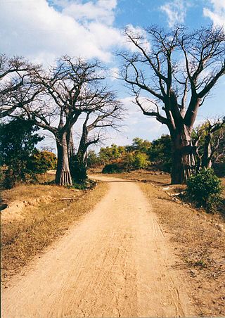
Transport in Mozambique

Last updated
Mz-map.png

Modes of transport in Mozambique include rail, road, water, and air. There are rail links serving principal cities and connecting the country with Malawi, Zimbabwe and South Africa. There are over 30,000km of roads, but much of the network is unpaved.

Contents

On the Indian Ocean coast are several large seaports, including Nacala, Beira and Maputo, with further ports being developed. There are 3,750km of navigable inland waterways. There is an international airport at Maputo, 21 other paved airports, and over 100 with unpaved runways.

Railways

Railway network of Mozambique Railways in Mozambique.svg
Railway network of Mozambique
Steam locomotive at Inhambane, 2009 Steam locomotive Inhambane.jpg
Steam locomotive at Inhambane, 2009

The Mozambican railway system developed over more than a century from three different ports on the Indian Ocean that serve as terminals for separate lines to the hinterland. The railroads were major targets during the Mozambican Civil War, were sabotaged by RENAMO, and are being rehabilitated. A parastatal authority, Portos e Caminhos de Ferro de Moçambique (abbreviated CFM; in English Mozambique Ports and Railways), oversees the railway system of Mozambique and its connected ports, but management has been largely outsourced. Each line has its own development corridor.

As of 2005 there are 3,123 km of railway track, consisting of 2,983 km of 1,067 mm (3 ft 6 in) gauge, compatible with neighboring rail systems, and a 140 km line of 762 mm (2 ft 6 in) gauge, the Gaza Railway. [1] The central Beira-Bulawayo railway and Sena railway route links the port of Beira to the landlocked countries of Malawi, Zambia and Zimbabwe. To the north of this the port of Nacala is also linked by Nacala rail to Malawi, and to the south the port of Maputo is connected by the Limpopo rail, the Goba rail and the Ressano Garcia rail to Zimbabwe, Eswatini and South Africa.. These networks interconnect only via neighbouring countries. A new route for coal haulage between Tete and Beira was planned to come into service by 2010, [2] and in August 2010, Mozambique and Botswana signed a memorandum of understanding to develop a 1,100 km railway through Zimbabwe, to carry coal from Serule in Botswana to a deepwater port at Techobanine Point in Mozambique. [3]

Newer rolling stock has been supplied by the Indian Golden Rock and BLW, Varanasi workshop [4] using Centre Buffer Couplers (AAR couplers) "Golden Rock workshop exports locos to Mozambique". The Hindu Business Line. Archived from the original on 6 December 2010. Retrieved 24 December 2014.</ref> and air brakes.

Towns served by railways

Roads and highways

Construction works for the Armando Guebuza Bridge, Mozambique (2008) Caia bridge.JPG
Construction works for the Armando Guebuza Bridge, Mozambique (2008)
Road N1 (2010) Mozambique 142.jpg
Road N1 (2010)

Mozambique's inter-city roads are classified as a national or primary road (estrada nacional or estrada primária), or as regional – secondary or tertiary – roads (estradas secundárias and estradas terciáreas). National roads are given the prefix "N" or "EN" followed by a one- or two-digit number. The numbers generally increase from the south of the country to the north. Regional roads are given the prefix "R", followed by a three-digit number. [5]

In 2008 the total length of Mozambique's road network was 32,500 km. The primary and secondary road networks were less than 5000 km each. The tertiary network was 12,700 km. Unclassified or local roads (estradas vicinais) were estimated at 6,700 km, and urban roads at 3,300 km. [6]

The national highway network includes 14 routes:

Petrol station in Gaza Province. Mozambique 122.jpg
Petrol station in Gaza Province.

Waterways

There are 3,750 km of navigable waterways.

Sea transport

Ports and harbours

Seaports on the Indian Ocean coast include:

Merchant marine

As of 2002 the merchant marine fleet consisted of three cargo ships of 1,000 gt or over, totaling 4,125 gt/7,024 tonnes deadweight (DWT). Two of these were Belgian-owned ships registered in Mozambique as a flag of convenience.

Airports

As of 2006 there were 158 airports in total, 22 of them having paved runways. The main airport in the country is Maputo International Airport, which is also the hub of Mozambique's flag carrier, LAM Mozambique Airlines.

Related Research Articles

<span class="mw-page-title-main">Transport in Malawi</span>

Transportation in Malawi is poorly developed. The country of almost 14 million has 39 airports, 6 with paved runways and 33 with unpaved runways. It has 797 kilometres of railways, all narrow-gauge and about 45 percent of its roads are paved. Though it is landlocked, Malawi also has 700 km (435 mi) of waterways on Lake Malawi and along the Shire River.

<span class="mw-page-title-main">Geography of Mozambique</span>

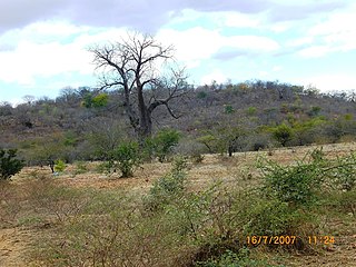
The geography of Mozambique consists mostly of coastal lowlands with uplands in its center and high plateaus in the northwest. There are also mountains in the western portion. The country is located on the east coast of southern Africa, directly west of the island of Madagascar. Mozambique has a tropical climate with two seasons, a wet season from October to March and a dry season from April to September.

This article is about the transport in Zambia.

<span class="mw-page-title-main">Nampula</span> City in Nampula Province, Mozambique

Nampula is the capital city of Nampula Province in Northern Mozambique. With a population of 743,125, it is the third-largest city in Mozambique after Maputo and Matola. The city is located in the interior of Nampula Province, approximately 200 kilometers from the coast and is surrounded by plains and rocky outcrops. The city is a major regional centre for the entire Northern region of Mozambique, as well as parts of Central Mozambique and border areas of Malawi and Tanzania.

<span class="mw-page-title-main">Moatize</span> Place in Tete Province, Mozambique

Moatize is the principal town and administrative center of Moatize District in western Mozambique's Tete Province. It is located on the eastern side of the Zambezi River at the confluence of the Moatize and Revuboe Rivers. After Tete, it is the second largest urban area, by population, in western Mozambique.

<span class="mw-page-title-main">Malawi Railways</span>

Malawi Railways was a government corporation that ran the national rail network of Malawi, Africa, until privatisation in 1999. With effect from 1 December 1999, the Central East African Railways consortium led by Railroad Development Corporation won the right to operate the network. This was the first rail privatisation in Africa which did not involve a parastatal operator.

Articles related to Mozambique include:

Eswatini Railways (ESR), formerly known as Swaziland Railway or Swazi Rail, is the national railway corporation of Eswatini.

<span class="mw-page-title-main">Mozambique Ports and Railways</span>

Portos e Caminhos de Ferro de Moçambique is a state-owned company that oversees the railway system of Mozambique and its connected ports.

<span class="mw-page-title-main">Beira–Lobito Highway</span>

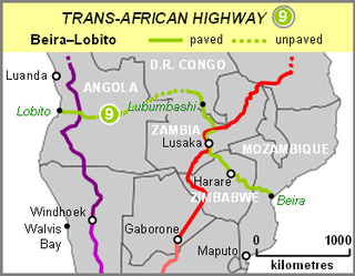
The Beira–Lobito Highway or TAH 9 is Trans-African Highway 9 in the transcontinental road network being developed by the United Nations Economic Commission for Africa (UNECA), the African Development Bank (ADB), and the African Union. The route has a length of 3,523 km (2,189 mi) crossing Angola, the most southerly part of the Democratic Republic of the Congo, Zambia, Zimbabwe, and central Mozambique.

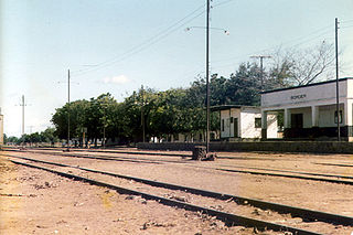
Railway stations in Mozambique include:

<span class="mw-page-title-main">Railway stations in Zambia</span>

Railway stations in Zambia include:

<span class="mw-page-title-main">A2 road (Zimbabwe)</span> Road in Zimbabwe

The A2 Highway is a primary road in Zimbabwe running from Harare to Nyamapanda at the border with Mozambique. The Mozambican side border post is called Cochemane. This is a busy entry point used by people travelling by road between South Africa, Malawi, Zimbabwe and Mozambique. It starts at intersection with Samora Machel Avenue; however Enterprise Road itself begins from the T-junction with Robert Mugabe Avenue, opposite the market in Eastlea, east of Simon Muzenda Street Road Port; a bus terminus for inter-regional buses.

Malawi Railways is the national rail network in Malawi, run by a government corporation until privatisation in 1999. As of 1 December 1999 the Central East African Railways, a consortium led by Railroad Development Corporation, won the right to operate the network.

<span class="mw-page-title-main">History of rail transport in Mozambique</span>

The history of rail transport in Mozambique began in the latter years of the nineteenth century.

<span class="mw-page-title-main">History of rail transport in Malawi</span>

The history of rail transport in Malawi began shortly after the turn of the twentieth century.

<span class="mw-page-title-main">Nacala railway</span>

Nacala railway, also known as Northern Corridor railway and Nacala Corridor railway, is a railway line that operates in northern Mozambique on a 912 kilometres (567 mi) line that runs west from the port city of Nacala, crossing the central region of Malawi, connecting with the coal belt of Moatize, in northwest Mozambique. It is connected to the Dona Ana-Moatize railway branch and the Sena railway (Chipata-Lilongwe-Blantyre-Nhamayabue-Dondo). It also has a 262 kilometres (163 mi) branch line from Cuamba to Lichinga.

<span class="mw-page-title-main">Sena railway</span>

Sena railway, also called Shire Highlands railway, Dondo-Malawi railway and North-South Malawi railway, is a railway that connects Dondo, Mozambique, to Chipata, in Zambia. It is c. 1000 km long, in a 1067 mm gauge.

<span class="mw-page-title-main">Limpopo railway</span> Railway line in Africa

Limpopo Railway, also called Gweru-Maputo railway, is a railway that connects the city of Maputo, Mozambique, to the city from Somabhula, in Zimbabwe. It is 900 km long, in a 1067 mm gauge.

References

  1. CIA factbook
  2. "Mozambique: Australian Company Plans New Coal Mine in Tete By 2010". Allafrica.com. Retrieved 24 December 2014.
  3. "Railway Gazette: Pointers September 2010" . Retrieved 2010-09-10.
  4. Railway Gazette International , August 2008, p.483
  5. "Road numbering systems: Mozambique". Accessed 9 April 2020. https://sites.google.com/site/roadnumberingsystems/home/countries/mozambique
  6. Dominguez-Torres, Carolina, and Cecilia Briceño-Garmendia (2011). Mozambique’s Infrastructure: A Continental Perspective. The World Bank, June 2011. https://ppiaf.org/documents/3152/download
  7. "New Mozambique port gets approval". Railways Africa. Retrieved 24 December 2014.

Rail network maps

PD-icon.svg This article incorporates  public domain material from the CIA document: World Factbook.