Transport in Guinea

Last updated
Three men hold on to the back of a moving matatu, Guinea, 2014. Strada Conakry- Boffa Guinea.jpg
Three men hold on to the back of a moving matatu, Guinea, 2014.

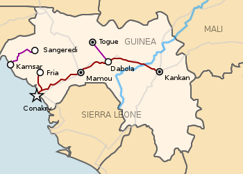
Transport in Guinea is composed by a variety of systems that people in the country use to get around as well as to and from domestic and international destinations. The railway from Conakry to Kankan ceased operating in the mid-1980s. [1] Most vehicles in Guinea are 20+ years old, and cabs are any four-door vehicle which the owner has designated as being for hire. Domestic air services are intermittent. Conakry International Airport is the largest airport in the country, with flights to other cities in Africa as well as to Europe.

Contents

Locals, nearly entirely without vehicles of their own, rely upon these taxis (which charge per seat) and small buses to take them around town and across the country. There is some river traffic on the Niger and Milo rivers. Horses and donkeys pull carts, primarily to transport construction materials.

Iron mining at Simandou (North and South blocks) in the southeast is leading to the construction of a new heavy-haul standard gauge railway and deep-water port. Bauxite mining at Kalia in the east is may link to this line.

Railways

.mw-parser-output .legend{page-break-inside:avoid;break-inside:avoid-column}.mw-parser-output .legend-color{display:inline-block;min-width:1.25em;height:1.25em;line-height:1.25;margin:1px 0;text-align:center;border:1px solid black;background-color:transparent;color:black}.mw-parser-output .legend-text{}
1000 mm gauge tracks
1435 mm gauge tracks Railways in Guinea.svg
  1000 mm gauge tracks
  1435 mm gauge tracks

total: 1,155km
standard gauge: 366km 1,435 mm (4 ft 8+12 in) gauge
metre gauge: 789km 1,000 mm (3 ft 3+38 in) gauge (includes 662km in common carrier service from Kankan to Conakry) [2]

The lines do not all connect.

Santou - Dapilon

This 125km long standard gauge railway connects bauxite mines in the Santou II and Houda areas with a new port at Dapilon, both places in the north of Guinea. [3] [4]

See: Boffa-Boke Railway

Chemin de Fer de Boké

This 136km long standard gauge railway connects bauxite mines at Sangaredi with Port Kamsar and carries about 12,000,000  t (11,810,478 long tons ; 13,227,736 short tons ) per annum.

Chemin de fer de Conakry – Fria

This 127km line is 1,000 mm (3 ft 3+38 in) gauge and heads off in a northwestern direction. It shares its first 16km with Chemin de Fer de Guinee.

Chemin de Fer de Guinee

This 662km line is 1,000 mm (3 ft 3+38 in) gauge. Conversion to 1,435 mm (4 ft 8+12 in) gauge has been proposed.

Societe des Bauxites de Kindia (SBK)

This 105km line is standard gauge and parallels the Chemin de Fer de Guinee line between Canakry and Sofonia.

TransGuinean Railway (under construction 2025)

The Transguinean Railway will be 622km long and of 1,435 mm (4 ft 8+12 in) (standard gauge). It goes from Simandou iron ore mines in the south east to a new port at Matakong. [5] [6]

Timeline

2021

2019

2008

  • July 2008 - wobbles over Simandou leases [8]
  • four ex-Croatian locomotives refurbished and regauged in Russia [9]

1994

Statistics

Highways

total: 30,500 km
paved: 5,033 km
unpaved: 25,467 km (1996 est.)

The Trans–West African Coastal Highway crosses Guinea, connecting it to Bissau (Guinea-Bissau), and when construction in Sierra Leone and Liberia is complete, to a total of 13 other nations of the Economic Community of West African States (ECOWAS).

Waterways

1,295 km navigable by shallow-draft native craft

Ports and harbors

Merchant marine

none (1999 est.)

Airports

15 (1999 est.)

Airports - with paved runways

total: 5
over 3,047 m: 1
2,438 to 3,047 m: 1
1,524 to 2,437 m: 3 (1999 est.)

The airport code for the capital, Conakry, is CKY.

Airports - with unpaved runways

total: 10
1,524 to 2,437 m: 5
914 to 1,523 m: 4
under 914 m: 1 (1999 est.)

See also

Related Research Articles

<span class="mw-page-title-main">Transport in Bosnia and Herzegovina</span>

Bosnia and Herzegovina has facilities for road, rail and air transport. There are five international road routes and 20 state highways, with bus connections to many countries. Railways total just over 1,000 km with links to Croatia and Serbia. There are 25 airports, seven of them with paved runways. The Sava River is navigable, but its use is limited.

<span class="mw-page-title-main">Transport in Chile</span>

Transport in Chile is mostly by road. The far south of the country is not directly connected to central Chile by road without travelling through Argentina, and water transport also plays a part there. The railways were historically important in Chile, but now play a relatively small part in the country's transport system. Because of the country's geography and long distances between major cities, aviation is also important.

<span class="mw-page-title-main">Transport in the Dominican Republic</span>

Transport in the Dominican Republic utilizes a system of roads, airports, ports, harbours, and an urban railway.

<span class="mw-page-title-main">Transport in Eritrea</span>

Transport in Eritrea includes highways, airports and seaports, in addition to various forms of public and private vehicular, maritime and aerial transportation.

For Soviet transportation, see Transport in the Soviet Union.

<span class="mw-page-title-main">Transport in Greece</span> Economy of Greece

Transport in Greece has undergone significant changes in the past two decades, vastly modernizing the country's infrastructure and transportation. Although ferry transport between islands remains the prominent method of transport between the nation's islands, improvements to the road infrastructure, rail, urban transport, and airports have all led to a vast improvement in transportation. These upgrades have played a key role in supporting Greece's economy, which in the past decade has come to rely heavily on the construction industry.

Transportation in Guatemala includes roads, waterways, airports and a short cross-border rail line from Mexico.

Transport in Hungary relies on several main modes, including transport by road, rail, air and water.

<span class="mw-page-title-main">Transport in Liberia</span>

Transport in Liberia consists of 243 km of railways, 6,580 miles of highways, seaports, 29 airports and 2 miles of pipeline for oil transportation. Buses and taxis are the main forms of ground transportation in and around Monrovia. Charter boats are also available.

Transport in Lithuania relies mainly on road and rail networks.

Transport in Poland involves air, water, road and rail transportation. The country has a large network of municipal public transport, such as buses, trams and the metro. As a country located at the 'cross-roads' of Europe, Poland is a nation with a large and increasingly modern network of transport infrastructure.

<span class="mw-page-title-main">Transport in Peru</span>

This article describes the transport in Peru.

<span class="mw-page-title-main">Transport in Spain</span>

Transport in Spain is characterised by a network of roads, railways, trams, air routes, and ports. Its geographic location makes it an important link between Europe, Africa, and the Americas. Major forms of transit generally radiate from the capital, Madrid, located in the centre of the country, to link with the capitals of the autonomous communities.

<span class="mw-page-title-main">Transport in Syria</span>

Transport in Syria is possible by rail, road, air or rivers, both public and private. Syria is an Asian country with a well-developed rail network (2,052 km) and a highway system (782 km). Main international airport is the Damascus International Airport in the capital, Damascus.

<span class="mw-page-title-main">5 ft and 1520 mm gauge railways</span> Railway track gauge

Railways with a railway track gauge of 5 ft first appeared in the United Kingdom and the United States. This gauge became commonly known as "Russian gauge", because the government of the Russian Empire chose it in 1843. Former areas and states of the Empire have inherited this standard. However in 1970, Soviet Railways re-defined the gauge as 1,520 mm.

The Transguinean Railways is a proposed set of heavy haul standard gauge railways in Guinea to support haulage of primarily iron ore and bauxite.

Railway stations in Guinea include:

<span class="mw-page-title-main">Rail transport in Guinea</span>

Guinea has 1,155km of railways. This comprises 366km at 1,435 mm gauge and 789km at 1,000 mm gauge. The latter includes 662km in common carrier service from Kankan to Conakry most of which is abandoned.

Mali has one railroad, including 729 kilometers in Mali, which runs from the port of Koulikoro via Bamako to the border with Senegal and continues on to Dakar. The Bamako-Dakar line, which has been described as dilapidated, was owned by a joint company established by Mali and Senegal in 1995, with the eventual goal of privatization. In 2003, the two countries sold a 25-year concession to run the rail line to a Canadian company, which has pledged to upgrade equipment and infrastructure.

References

  1. "Railways in Guinea". sinfin.net. Retrieved 2016-08-10.
  2. United States Central Intelligence Agency (1997). "The World Factbook" . Retrieved January 16, 2020.
  3. "Dapilon-Santou Rail Project". Railway Technology. Retrieved 2025-01-11.
  4. International2021-06-28T11:00:00+01:00, Railway Gazette. "Guinean bauxite railway inaugurated". Railway Gazette International. Retrieved 2025-01-11.{{cite web}}: CS1 maint: numeric names: authors list (link)
  5. Wilson, Tom (2024-01-07). "World's biggest mining project to start after 27 years of setbacks and scandals". Financial Times. Retrieved 2025-01-11.
  6. "Transguinean". www.teamgroup.it. Retrieved 2018-12-15.
  7. "Guinea railway between Télimélé and Boffa". www.railwaysafrica.com.
  8. "Rio's Simandou blue is no hiccup, despite assurances | the Australian". Archived from the original on 2008-07-31. Retrieved 2018-12-28.
  9. Railway Gazette International February 2008 p73
  10. Izon, David (June 1995). "The Mineral Industry of Guinea" (PDF). minerals.usgs.gov. Archived (PDF) from the original on 2003-06-29. Retrieved 2018-12-15.