Portuguese Mozambique or Portuguese East Africa were the common terms by which Mozambique was designated during the historic period when it was a Portuguese colony. Portuguese Mozambique originally constituted a string of Portuguese possessions along the south-east African coast, and later became a unified colony, which now forms the Republic of Mozambique.

The Zambezi is the fourth-longest river in Africa, the longest east-flowing river in Africa and the largest flowing into the Indian Ocean from Africa. The area of its basin is 1,390,000 square kilometres (540,000 sq mi), slightly less than half of the Nile's. The 2,574-kilometre-long river (1,599 mi) arises in Zambia and flows through eastern Angola, along the north-eastern border of Namibia and the northern border of Botswana, then along the border between Zambia and Zimbabwe to Mozambique, where it crosses the country to empty into the Indian Ocean.

Sofala is a province of Mozambique. It has a population of 2,259,248. Beira is the capital of the province, named for the ruined port of Sofala which is 35 kilometres (22 mi) to the south.

Tete is the capital city of Tete Province in Mozambique. It is located on the Zambezi River, and is the site of two of the four bridges crossing the river in Mozambique. A Swahili trade center before the Portuguese colonial era, Tete continues to dominate the west-central part of the country and region, and is the largest city on the Zambezi. In the local language, Nyungwe, Tete means "reed."

Manica is a province of Mozambique. It has an area of 62,272 km² and a population of 1,945,994. The province is surrounded by Zimbabwe in the west, Tete Province in the northwest, Sofala Province in the east, Save River in the south, and Zambezi river in the northeast. Chimoio is the capital of the province. The highest mountain in Mozambique, Mount Binga, lies in this province near the border with Zimbabwe. The Manica province is divided into nine districts and 34 administrative regions.

Nsanje is the main town in Nsanje District within the Southern Region of Malawi.

Chindio is a village on the north bank of the Zambezi River in Mozambique, downstream of its junction with the Shire River. Chindio is not the same place as Chinde, although they are both on the Zambezi and in Mozambique.
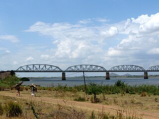
The Dona Ana Bridge spans the lower Zambezi River between the towns of Vila de Sena and Mutarara in Mozambique, effectively linking the two halves of the country. It was originally constructed as a railway bridge to link Malawi and the Moatize coal fields to the port of Beira.

Caia District is a district of Sofala Province in Mozambique. The principal town is Caia. The district is located in the north of the province, and borders with Chemba District in the north, Marromeu District in the southeast, Cheringoma District in the south, and with Maringué District in the west. In the east, the district is bounded by the Indian Ocean. The area of the district is 3,542 square kilometres (1,368 sq mi). It has a population of 115,455 as of 2007.

Chemba District is a district of Sofala Province in Mozambique. The principal town is Chemba. The district is located in the north of the province, and borders with Tete Province in the northeast, Caia District in the southeast, Maringué District in the southwest, and with Tambara District of Manica Province in the northwest. The area of the district is 3,998 square kilometres (1,544 sq mi). It has a population of 65,107 as of 2007.

Cheringoma District is a district of Sofala Province in Mozambique. The principal town is Inhaminga. The district is located in the northeast of the province, and borders with Caia District in the north, Marromeu District in the northeast, Muanza District in the south, Gorongosa District in the west, and with Maringué District in the northwest. In the south, it is bounded by the Indian Ocean. The area of the district is 6,954 square kilometres (2,685 sq mi). It has a population of 34,133 as of 2007.
Marromeu District is a district of Sofala Province in Mozambique. The principal town is Marromeu. The district is located in the northeast of the province, and borders with Chinde and Mopeia Districts of Zambezia Province in the north, Cheringoma District in the south and in the west, and with Caia District in the northwest. In the southeast, the district is limited by the Indian Ocean. The area of the district is 5,871 square kilometres (2,267 sq mi). It has a population of 119,718 as of 2007.
Vila de Sena or more commonly Sena is a town in Mozambique where there is a fundamental bridge over the Zambezi River. This bridge, the Dona Ana Bridge was originally a single track railway bridge, temporarily converted to road operation during the civil war.
Railway stations in Mozambique include:
Inhaminga is an administrative post of Cheringoma District of Sofala Province in Mozambique. It limits to the north and northwest by the district of Caia, on the west by districts of Gorongosa and Maringue, south to Mwanza district, southeast Indian Ocean to the east and northeast and to the district of Marromeu.
Mutarara is a town in Mozambique. It lies on the north bank of the Zambezi River.

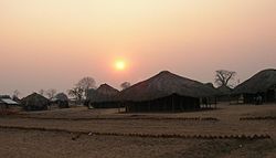
The Sena people are an ethnic group, with origins in northwestern region of Mozambique in Tete Province, Manica Province, Sofala Province and Zambezia Province. They are also found in Malawi and Zimbabwe near their respective borders with Mozambique.

Armando Emilio Guebuza Bridge is a bridge in Mozambique that crosses the Zambezi River. It connects the provinces of Sofala and Zambezia. It is named after Armando Guebuza, the President of Mozambique.

Sena railway, also called Shire Highlands railway, Dondo-Malawi railway and North-South Malawi railway, is a railway that connects the city of Dondo, Mozambique, to the city from Chipata, in Zambia. It is c. 1000 km long, in a 1067 mm gauge.