Armando Emilio Guebuza Bridge

Last updated
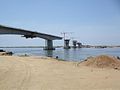
Armando Emilio Guebuza Bridge

Portuguese: Ponte Armando Emílio Guebuza
Ponte AEG.JPG
Coordinates 17°48′29″S35°23′51″E / 17.8081°S 35.3975°E / -17.8081; 35.3975 Coordinates: 17°48′29″S35°23′51″E / 17.8081°S 35.3975°E / -17.8081; 35.3975
CarriesEN1 (2 lanes)
Crosses Zambezi River
Locale Caia and Chimuara
Other name(s)Zambezi River Bridge
Maintained byNational Road Administration
Preceded by Dona Ana Bridge
Characteristics
Design Box girder bridge
Total length2,376 metres (7,795 ft)
Width16 metres (52 ft)
No. of spans6
History
Designer WSP Global
Constructed by Mota-Engil
Soares da Costa
Construction startDecember 2005
Construction cost€ 66 million
Inaugurated1 August 2009
ReplacesFerry service
Statistics
TollUS$ 3 (light vehicles)
US$ 30 (trucks)
Mozambique relief location map.jpg
Red pog.svg
Armando Emilio Guebuza Bridge
Location in Mozambique

Armando Emilio Guebuza Bridge is a bridge in Mozambique that crosses the Zambezi River. It connects the provinces of Sofala and Zambezia. [1] [2] It is named after Armando Guebuza, a former President of Mozambique.

Contents

See also

Related Research Articles

Transport in Malawi

Transportation in Malawi is poorly developed. The country of almost 14 million has 39 airports, 6 with paved runways and 33 with unpaved runways. It has 495 miles (797 km) of railways, all narrow-gauge and about 45 percent of its roads are paved. Though it is landlocked, Malawi also has 435 miles (700 km) of waterways on Lake Malawi and along the Shire River.

Mozambique Country on the east coast of Southern Africa

Mozambique, officially the Republic of Mozambique, is a country located in Southeast Africa bordered by the Indian Ocean to the east, Tanzania to the north, Malawi and Zambia to the northwest, Zimbabwe to the west, and Eswatini (Swaziland) and South Africa to the southwest. The sovereign state is separated from the Comoros, Mayotte and Madagascar by the Mozambique Channel to the east. The capital and largest city of Mozambique is Maputo.

Mozambique was a Portuguese colony, overseas province and later a member state of Portugal. It gained independence from Portugal in 1975.

Zambezi fourth-longest river in Africa

The Zambezi is the fourth-longest river in Africa, the longest east-flowing river in Africa and the largest flowing into the Indian Ocean from Africa. The area of its basin is 1,390,000 square kilometres (540,000 sq mi), slightly less than half of the Nile's. The 2,574-kilometre-long river (1,599 mi) arises in Zambia and flows through eastern Angola, along the north-eastern border of Namibia and the northern border of Botswana, then along the border between Zambia and Zimbabwe to Mozambique, where it crosses the country to empty into the Indian Ocean.

Tete, Mozambique Place in Tete Province, Mozambique

Tete is the capital city of Tete Province in Mozambique. It is located on the Zambezi River, and is the site of two of the four bridges crossing the river in Mozambique. A Swahili trade center before the Portuguese colonial era, Tete continues to dominate the west-central part of the country and region, and is the largest city on the Zambezi. In the local language, Nyungwe, Tete means "reed."

Armando Guebuza Mozambican politician

Armando Emílio Guebuza is a Mozambican politician who was President of Mozambique from 2005 to 2015.

Victoria Falls Bridge deck arch bridge in Zambia

The Victoria Falls Bridge crosses the Zambezi River just below the Victoria Falls and is built over the Second Gorge of the falls. As the river forms the border between Zimbabwe and Zambia, the bridge links the two countries and has border posts on the approaches to both ends, at the towns of Victoria Falls, Zimbabwe and Livingstone, Zambia.

Dona Ana Bridge bridge

The Dona Ana Bridge spans the lower Zambezi River between the towns of Vila de Sena and Mutarara in Mozambique, effectively linking the two halves of the country. It was originally constructed as a railway bridge to link Malawi and the Moatize coal fields to the port of Beira.

Caia, Mozambique Place in Sofala Province, Mozambique

Caia is a town on the south bank of the Zambezi River in Sofala Province, Mozambique. It is a relatively small town with few modern facilities besides a petrol station and the neighbouring bank. Caia and surrounding communities have been experiencing an escalating HIV/AIDS epidemic, drawing national and foreign aid to the area, including a Canadian foundation called the Caia Connection based in Vila de Sena, 57.6 Kilometres north of Caia.

Filipe Nyusi President of Mozambique (2015-present)

Filipe Jacinto Nyusi, also spelled Nyussi, is a Mozambican politician serving as the fourth President of Mozambique, in office since 2015. He previously served as Minister of Defence from 2008 to 2014. Nyusi was the candidate of the ruling party, Frelimo, in the 2014 presidential election.

Maria Benvinda Levy is a Mozambican politician and former judge.

Antonio Francisco Munguambe is a Mozambican politician.

Aires Ali FRELIMO politician

Aires Bonifácio Baptista Ali is a Mozambican politician who was Prime Minister of Mozambique from 16 January 2010 to 8 October 2012, when he was sacked by Mozambican President Armando Guebuza in a cabinet reshuffle.

Malawi–Mozambique relations Diplomatic relations between the Republic of Malawi and the Republic of Mozambique

Malawi–Mozambique relations refers to the current and historical relationship between the countries of Malawi and Mozambique. As Malawi shares a large border with Mozambique, much of the substance of their foreign relations pertain to the border separating the two nations. Both of the sovereign states have amicably agreed that lacustrine borders on Lake Malawi remain the largest priority between the two countries, as the exploitation of natural resources within the waters of Lake Malawi remain an issue the two countries continue to resolve. The moment considered an act of generosity and sympathy within the two countries relations is when, during the Mozambique Civil War, Malawi housed over one million Mozambican refugees between 1985 and 1995. After this gesture, Malawian relations with Mozambique crumbled under the tenure of Bingu wa Mutharika, notoriously reaching a nadir when Malawian police launched a raid into Mozambique's territory.

Samora Machel Bridge suspension bridge across Sambesi

Samora Machel Bridge is a bridge in Mozambique across the Zambezi River. It is named after Samora Machel, the former President of Mozambique.

Kassuende Bridge bridge in Mozambique

Kassuende Bridge is a bridge in Mozambique across the Zambezi River. It is about 6 kilometres (3.7 mi) downstream from the Samora Machel Bridge. People traveling between Malawi and Zimbabwe do not need to pass through Tete and this helps in reducing the traffic on the current bridge.

Mphanda Nkuwa Dam

Mphanda Nkuwa Dam is a proposed hydroelectric dam on the Zambezi River in Mozambique. The dam would be located about 60 kilometres (37 mi) downstream of the existing Cahora Bassa Dam near the city of Tete. Its power station would have a capacity of 1,500 megawatts.

Athi River Super Bridge bridge in Kenya

The Athi River Super Bridge is the longest bridge on the Mombasa–Nairobi Standard Gauge Railway (SGR). It was built to carry a single-track railway line over the Athi River as it approaches the Kenyan capital city of Nairobi. At the time of its construction, the 2.6 km (1.6 mi) bridge was the sixth-longest bridge in Africa and the second-longest railway bridge, exceeded only by the Dona Ana Bridge at 3.67 km (2.28 mi).

References

  1. "Zambezi Bridge inaugurated". High Commission of the Republic of Mozambique in London. 5 August 2009. Retrieved 8 March 2013.
  2. "New bridge unites Mozambique". Swedish International Development Cooperation Agency. 7 September 2009. Archived from the original on 18 April 2013. Retrieved 8 March 2013.