
Mozambique, officially the Republic of Mozambique, is a country located in southeast Africa bordered by the Indian Ocean to the east, Tanzania to the north, Malawi and Zambia to the northwest, Zimbabwe to the west, and Eswatini and South Africa to the southwest. The sovereign state is separated from the Comoros, Mayotte and Madagascar by the Mozambique Channel to the east. The capital and largest city is Maputo.

Modes of transport in Mozambique include rail, road, water, and air. There are rail links serving principal cities and connecting the country with Malawi, Zimbabwe and South Africa. There are over 30,000km of roads, but much of the network is unpaved.

Portuguese Mozambique or Portuguese East Africa were the common terms by which Mozambique was designated during the period in which it was a Portuguese colony. Portuguese Mozambique originally constituted a string of Portuguese possessions along the south-east African coast, and later became a unified colony, which now forms the Republic of Mozambique.

Maputo is the capital, and largest city of Mozambique. Located near the southern end of the country, it is within 120 kilometres of the borders with Eswatini and South Africa. The city has a population of 1,088,449 distributed over a land area of 347.69 km2 (134.24 sq mi). The Maputo metropolitan area includes the neighbouring city of Matola, and has a total population of 2,717,437. Maputo is a port city, with an economy centered on commerce. It is also noted for its vibrant cultural scene and distinctive, eclectic architecture. Maputo was formerly named Lourenço Marques until 1976.

Sofala is a province of Mozambique. It has a population of 2,259,248. Beira is the capital of the province, named for the ruined port of Sofala which is 35 kilometres (22 mi) to the south.

Beira is the capital and largest city of Sofala Province, in the central region of Mozambique.
The Beira Railroad Corporation, or CCFB, was a joint venture railway company that was responsible for operating the railway lines in central Mozambique. It was formed to reform the railway lines that run from the Port of Beira, Mozambique, originally linking to Zimbabwe, although it later also linked to Malawi.

The Grande Hotel Beira is an abandoned luxury hotel in Beira, Mozambique. It was opened in 1954 and operated until 1974, when it was closed due to lack of guests. The building was used as a military base during the Mozambican Civil War. It is currently home to over 3,500 squatters.

Portos e Caminhos de Ferro de Moçambique is a state-owned company that oversees the railway system of Mozambique and its connected ports.
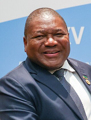
Filipe Jacinto Nyusi is a Mozambican politician serving since 2015 as the fourth President of Mozambique. He is the current leader of FRELIMO, the party that has governed Mozambique since its independence from Portugal in 1975. Additionally, he has served as the Chairman of the Southern African Development Community since August 2020. During his time in office, President Nyusi has promoted peace and security, and signed multiple agreements with the main opposition parties, RENAMO, to bring a definitive and lasting peace to Mozambique.
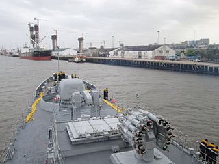
The Port of Maputo, also called the Maputo-Matola port complex, is a Mozambican port located in the cities of Maputo and Matola. They are installed in Maputo Bay, on the north bank of the Espírito Santo estuary, which is separated from the Mozambique Channel by the islands of Inhaca and Portugueses and by the Machangulo peninsula.
The Port of Nacala, also called the Nacala port complex, is a Mozambican port located in the cities of Nacala and Nacala-a-Velha. Is the deepest port in Southern Africa. The natural deep harbour serves landlocked Malawi with a 931-kilometre (578 mi) railway.

The history of rail transport in Mozambique began in the latter years of the nineteenth century.
CLIN, or the Sociedade do Corredor Logístico Integrado do Norte, is a business company related to logistics, whose main business is railway management in Mozambique and Malawi. The company is a joint venture.

The Liga Moçambicana de Basquetebol (LMB), known as the Liga Mozal for sponsorship reasons, is the highest basketball league in Mozambique. Founded in 1960, the league typically consists of eight teams. The winners of the competition earn the right to play in the qualifying tournaments of the Basketball Africa League (BAL).

Nacala railway, also known as Northern Corridor railway and Nacala Corridor railway, is a railway line that operates in northern Mozambique on a 912 kilometres (567 mi) line that runs west from the port city of Nacala, crossing the central region of Malawi, connecting with the coal belt of Moatize, in northwest Mozambique. It is connected to the Dona Ana-Moatize railway branch and the Sena railway (Chipata-Lilongwe-Blantyre-Nhamayabue-Dondo). It also has a 262 kilometres (163 mi) branch line from Cuamba to Lichinga.
The Cheringoma Plateau is a low plateau in Sofala Province of Mozambique. It lies mostly within Cheringoma, Muanza, and Marromeu districts.

Sena railway, also called Shire Highlands railway, Dondo-Malawi railway and North-South Malawi railway, is a railway that connects Dondo, Mozambique, to Chipata, in Zambia. It is c. 1000 km long, in a 1067 mm gauge.

Limpopo Railway, also called Gweru-Maputo railway, is a railway that connects the city of Maputo, Mozambique, to the city from Somabhula, in Zimbabwe. It is 900 km long, in a 1067 mm gauge.
Vila Nova de Fronteira is a Mozambican village in the district of Mutarara, located in the province of Tete. It is located on the Malawi-Mozambique Border, in front of the city of Marka.

