
This list of Ports and harbours in Mozambique details the ports, harbours around the coast of Mozambique.
This list of Ports and harbours in Mozambique details the ports, harbours around the coast of Mozambique.
Transportation in Malawi is poorly developed. The country of almost 14 million has 39 airports, 6 with paved runways and 33 with unpaved runways. It has 797 kilometres of railways, all narrow-gauge and about 45 percent of its roads are paved. Though it is landlocked, Malawi also has 700 km (435 mi) of waterways on Lake Malawi and along the Shire River.

Modes of transport in Mozambique include rail, road, water, and air. There are rail links serving principal cities and connecting the country with Malawi, Zimbabwe and South Africa. There are over 30,000km of roads, but much of the network is unpaved.
Nacala, also known as Cidade de Nacala or Nacala-Porto is a city on the northern coast of Mozambique. Located in the southwestern indentation of inner Fernao Veloso Bay, it is the deepest natural port on the east coast of Africa. Nacala serves as the terminal for the Nacala railway, a rail line to the landlocked Malawi. South of Nacala is Mozambique Island, at one time the capital of Mozambique and now a World Heritage site.
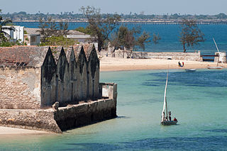
The Island of Mozambique lies off northern Mozambique, between the Mozambique Channel and Mossuril Bay, and is part of Nampula Province. Prior to 1898, it was the capital of colonial Portuguese East Africa. With its rich history and sandy beaches, the Island of Mozambique is a UNESCO World Heritage site and one of Mozambique's fastest-growing tourist destinations. It has a permanent population of approximately 14,000 people and is served by nearby Lumbo Airport on the Nampula mainland. The name of the country, Mozambique, is derived from the name of this island.

Lichinga is the capital city of Niassa Province of Mozambique. It lies on the Lichinga Plateau at an altitude of 1,360 metres (4,460 ft), east of Lake Niassa. The town was founded as Vila Cabral as a farming and military settlement. It is served by Lichinga Airport. The province borders Ruvuma Region in Tanzania.
Moatize is the principal town and administrative center of Moatize District in western Mozambique's Tete Province. It is located on the eastern side of the Zambezi River at the confluence of the Moatize and Revuboe Rivers. After Tete, it is the second largest urban area, by population, in western Mozambique.

Portos e Caminhos de Ferro de Moçambique is a state-owned company that oversees the railway system of Mozambique and its connected ports.
Railway stations in Mozambique include:
Malawi Railways is the national rail network in Malawi, run by a government corporation until privatisation in 1999. As of 1 December 1999 the Central East African Railways, a consortium led by Railroad Development Corporation, won the right to operate the network.
The Port of Nacala, also called the Nacala port complex, is a Mozambican port located in the cities of Nacala and Nacala-a-Velha. Is the deepest port in Southern Africa. The natural deep harbour serves landlocked Malawi with a 931-kilometre (578 mi) railway.
Nacala Airport is an airport near Nacala, in Nampula Province in Mozambique. Formerly a military airport, it underwent a major redevelopment to convert it to commercial use.

The history of rail transport in Mozambique began in the latter years of the nineteenth century.

Intense Tropical Cyclone Nadia was a powerful tropical cyclone that struck both Madagascar and Mozambique in March 1994. It formed on March 16 and moved westward for the first ten days of its duration. Warm waters and low wind shear allowed for the storm to gradually strengthen. After developing a well-defined eye, Nadia intensified to reach winds of 175 km/h early on March 22, according to Météo-France (MF). In contrast, the Joint Typhoon Warning Center (JTWC) estimated winds of about 220 km/h. On March 23, the cyclone struck northern Madagascar, causing flooding and localized damage where it moved ashore. There were 12 deaths in the country. Nadia emerged into the Mozambique Channel as a weakened storm, although it reintensified slightly before making landfall in northeastern Mozambique on March 24. The storm turned southward through the country, emerging over water on March 26. It turned to the northeast and meandered over waters before dissipating on April 1.
CLIN, or the Sociedade do Corredor Logístico Integrado do Norte, is a business company related to logistics, whose main business is railway management in Mozambique and Malawi. The company is a joint venture.
Fernao Veloso Bay is a bay in Mozambique. It is located in Nampula Province, south of Memba Bay on the northern coast of Mozambique.

Sena railway, also called Shire Highlands railway, Dondo-Malawi railway and North-South Malawi railway, is a railway that connects Dondo, Mozambique, to Chipata, in Zambia. It is c. 1000 km long, in a 1067 mm gauge.
Nacala Solar Power Station, is a planned solar power plant in Mozambique. The 100 megawatt installation is at the feasibility study stage. If and when the solar farm is developed, it will be the largest solar power station in the country. The development plans to include an energy-storage facility with capacity of 50 megawatts. The lead developer is WHN Solar Company, a Mozambican independent power producer (IPP).
Currency: Metical | |
| Communications | |
| Industries: | |
| Types | |
|---|---|
| Rankings | |
| Locations | |
| Port management | |
| Conventions | |