Nacala

Last updated
Nacala
Maiaia
Cidade de Nacala
NacalaBeach.jpg
The beach at Nacala
Nickname: 
Nacala-Porto
Mozambique adm location map.svg
Red pog.svg
Nacala
Coordinates: 14°27′S40°40′E / 14.450°S 40.667°E / -14.450; 40.667
Country Flag of Mozambique.svg  Mozambique
Provinces Nampula Province
District Nacala-porto
Government
  TypeDemocratico
  Presidente do MunicipioRaul Novinte
Population
 (2017 census)
  Total225,034
Climate Aw
Website https://www.facebook.com/CMCNacalaPorto

Nacala, also known as Cidade de Nacala or Nacala-Porto is a city on the northern coast of Mozambique. Located in the southwestern indentation of inner Fernao Veloso Bay, it is the deepest natural port on the east coast of Africa. Nacala serves as the terminal for the Nacala railway, a rail line to the landlocked Malawi. South of Nacala is Mozambique Island, at one time the capital of Mozambique and now a World Heritage Site.

Contents

History

Nacala was founded as a little town and developed as a deep waters port and an industrial, agricultural and exporting centre during the last period of the Portuguese rule of the territory which ended in the mid-1970s. Among its major industries were cement, sisal and cashew. Other important employers were the seaport, its small modern hospital, and services (banking, insurance and administration). [1]

Industry

Nacala is site of one of three cement works in Mozambique.

Transport

Nacala is the terminal of the Nacala railway that connects to the Central East African Railway (CEAR) of Malawi. The railway system was managed by the Railroad Development Corporation until September 2008 when it was sold to a group of Mozambican investors. [2]

It is the location of the deep water port of Port of Nacala. A coal terminal, operated by the Port of Nacala, is located in the town of Nacala-a-Velha on the opposite side of the bay from Nacala.

Nacala Airport is a former airbase that has been converted into an international airport.

Demographics

Year (census)Population [3]
1997158,248
2007206,449
2017225,034

Climate

Climate data for Nacala
MonthJanFebMarAprMayJunJulAugSepOctNovDecYear
Average high °C (°F)32
(89)
32
(89)
32
(89)
32
(89)
31
(88)
30
(86)
29
(85)
30
(86)
31
(87)
32
(89)
32
(89)
32
(89)
31
(88)
Average low °C (°F)19
(67)
19
(67)
19
(67)
18
(65)
17
(63)
16
(61)
16
(60)
15
(59)
16
(61)
18
(64)
18
(65)
19
(66)
18
(64)
Average precipitation mm (inches)190
(7.6)
190
(7.6)
170
(6.7)
56
(2.2)
13
(0.5)
10
(0.4)
2.5
(0.1)
7.6
(0.3)
5.1
(0.2)
5.1
(0.2)
33
(1.3)
120
(4.8)
810
(31.8)
Source: Weatherbase [4]

Miscellaneous

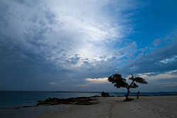
The town is also known for its beaches and scuba diving.

Namesake

There is another town in Mozambique that contains the name Nacala, it is called Nacala-a-Velha ("The Old Nacala"), just across the bay (c. 30km by road).

See also

Related Research Articles

<span class="mw-page-title-main">Transport in Malawi</span>

Transportation in Malawi is poorly developed. The country of almost 14 million has 39 airports, 6 with paved runways and 33 with unpaved runways. It has 797 kilometres of railways, all narrow-gauge and about 45 percent of its roads are paved. Though it is landlocked, Malawi also has 700 km (435 mi) of waterways on Lake Malawi and along the Shire River.

<span class="mw-page-title-main">Geography of Mozambique</span> Geographical features of Mozambique

The geography of Mozambique consists mostly of coastal lowlands with uplands in its center and high plateaus in the northwest. There are also mountains in the western portion. The country is located on the east coast of southern Africa, directly west of the island of Madagascar. Mozambique has a tropical climate with two seasons, a wet season from October to March and a dry season from April to September.

<span class="mw-page-title-main">Transport in Mozambique</span>

Modes of transport in Mozambique include rail, road, water, and air. There are rail links serving principal cities and connecting the country with Malawi, Zimbabwe and South Africa. There are over 30,000km of roads, but much of the network is unpaved.

<span class="mw-page-title-main">Nampula</span> City in Nampula Province, Mozambique

Nampula[nɐ̃ˈpulɐ] is the capital city of Nampula Province in Northern Mozambique. With a population of 743,125, it is the third-largest city in Mozambique after Maputo and Matola. The city is located in the interior of Nampula Province, approximately 200 kilometers from the coast and is surrounded by plains and rocky outcrops. The city is a major regional centre for the entire Northern region of Mozambique, as well as parts of Central Mozambique and border areas of Malawi and Tanzania.

<span class="mw-page-title-main">Inhambane</span> City in Inhambane Province, Mozambique

Inhambane[iɲɐ̃ˈbani], also known as Terra de Boa Gente, is a city located in southern Mozambique, lying on Inhambane Bay, 470 km northeast of Maputo. It is the capital of the Inhambane Province and according to the 2017 census has a population of 79,724, growing from the 1997 census of 54,157.

<span class="mw-page-title-main">Moatize</span> Place in Tete Province, Mozambique

Moatize is the principal town and administrative center of Moatize District in western Mozambique's Tete Province. It is located on the eastern side of the Zambezi River at the confluence of the Moatize and Revuboe Rivers. After Tete, it is the second largest urban area, by population, in western Mozambique.

<span class="mw-page-title-main">Malawi Railways</span> Former government corporation running Malawis rail network

Malawi Railways was a government corporation that ran the national rail network of Malawi, Africa, until privatisation in 1999. With effect from 1 December 1999, the Central East African Railways consortium led by Railroad Development Corporation won the right to operate the network. This was the first rail privatisation in Africa which did not involve a parastatal operator.

<span class="mw-page-title-main">Mozambique Ports and Railways</span> Railway system of Mozambique and its connected ports

Portos e Caminhos de Ferro de Moçambique is a state-owned company that oversees the railway system of Mozambique and its connected ports.

Nacala-a-Velha District is a district of Nampula Province in north-eastern Mozambique.

Central East African Railways is a consortium formed in 1999, led by the Railroad Development Corporation, which won the right to operate the Malawi Railways network. The company was sold in September 2008 to INSITEC, an investment group based in Mozambique.

Railway stations in Mozambique include:

Malawi Railways is the national rail network in Malawi, run by a government corporation until privatisation in 1999. As of 1 December 1999 the Central East African Railways, a consortium led by Railroad Development Corporation, won the right to operate the network.

The Port of Nacala, also called the Nacala port complex, is a Mozambican port located in the cities of Nacala and Nacala-a-Velha. Is the deepest port in Southern Africa. The natural deep harbour serves landlocked Malawi with a 931-kilometre (578 mi) railway.

CLIN, or the Sociedade do Corredor Logístico Integrado do Norte, is a business company related to logistics, whose main business is railway management in Mozambique and Malawi. The company is a joint venture.

Nacala-a-Velha, is a town on the northern coast of Mozambique. It is located on the western shore of inner Fernao Veloso Bay, opposite the city of Nacala.

Memba Bay is a bay in Mozambique. It is located in Nampula Province, north of Fernao Veloso Bay, on the northern coast of Mozambique.

Fernao Veloso Bay is a bay in Mozambique. It is located in Nampula Province, south of Memba Bay on the northern coast of Mozambique.

<span class="mw-page-title-main">Nacala railway</span> Railway line in Mozambique and Malawi

Nacala railway, also known as Northern Corridor railway and Nacala Corridor railway, is a railway line that operates in northern Mozambique on a 912 kilometres (567 mi) line that runs west from the port city of Nacala, crossing the central region of Malawi, connecting with the coal belt of Moatize, in northwest Mozambique. It is connected to the Dona Ana-Moatize railway branch and the Sena railway (Chipata-Lilongwe-Blantyre-Nhamayabue-Dondo). It also has a 262 kilometres (163 mi) branch line from Cuamba to Lichinga.

The Nacala Logistics Corridor is a logistical mega-enterprise for connecting areas in Southeast Africa, which includes the creation and management of railways, highways, ports and airports, which directly serve Mozambique and Malawi, and indirectly to Zambia and Zimbabwe.

<span class="mw-page-title-main">Sena railway</span> Railway line in Africa

Sena railway, also called Shire Highlands railway, Dondo-Malawi railway and North-South Malawi railway, is a railway that connects Dondo, Mozambique, to Chipata, in Zambia. It is c. 1000 km long, in a 1067 mm gauge.

References

  1. Nacala - no outro lado do tempo, short film of Nacala, Portuguese Mozambique before independence in 1975.
  2. RDC management
  3. "Mozambique: largest cities and towns and statistics of their population". World Gazetteer. Retrieved 2008-06-18.[ dead link ]
  4. "Weatherbase: Historical Weather for Nacala, Mozambique". Weatherbase. 2011. Retrieved on November 24, 2011.

14°32′34″S40°40′22″E / 14.54278°S 40.67278°E / -14.54278; 40.67278