
Maputo is the capital and largest city of Mozambique. Located near the southern end of the country, it is within 120 kilometres of the borders with Eswatini and South Africa. The city has a population of 1,088,449 distributed over a land area of 347.69 km2 (134.24 sq mi). The Maputo metropolitan area includes the neighbouring city of Matola, and has a total population of 2,717,437. Maputo is a port city, with an economy centered on commerce. It is noted for its vibrant cultural scene and distinctive, eclectic architecture. Maputo was formerly named Lourenço Marques.

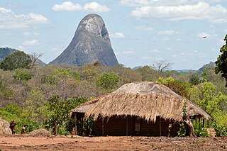
Niassa is a province of Mozambique with an area of 129,056 km2 and a population of 1,810,794 (2017). It is the most sparsely populated province in the country. Lichinga is the capital of the province. There are a minimum estimated 450,000 Yao people living in Mozambique. They largely occupy the eastern and northern part of the Niassa province and form about 40% of the population of Lichinga, the capital of this province.
Nampula is a province of northern Mozambique. It has an area of 79,010 km2 (30,510 sq mi) and a population of 5,758,920, making it the most populous province in Mozambique. Nampula is the capital of the province.
Maputo Province is a province of Mozambique; the province excludes the city of Maputo. The province has an area of 22,693 km2 (8,762 sq mi) and a population of 1,968,906. Its capital is the city of Matola.

Marracuene District is a district of Maputo Province in southern Mozambique. The principal town is Marracuene. The district is located in the center of the province, and borders with Manhiça District in the north, the city of Maputo in the south, and with the city of Matola and with Moamba District in the west. In the east, the district is limited by the Indian Ocean. The area of the district is 703 square kilometres (271 sq mi). It has a population of 136,784 as of 2007.

Namaacha District is a district of Maputo Province in southern Mozambique. The principal town is Namaacha. The district is located in the southwest of the province, and borders with Moamba District in the north, Boane District in the east, Matutuíne District in the south, and with Eswatini and South Africa in the west. The area of the district is 2,196 square kilometres (848 sq mi). It has a population of 41,914 as of 2007.

Massingir District is a district of Gaza Province in southwestern Mozambique. The administrative center of the district is in Massingir. The district is located in the west of the province, and borders with Chicualacuala District in the north, Mabalane District in the east, Chókwè District in the southeast, Magude District of Maputo Province in the south, and with South Africa in the west. The area of the district is 5,893 square kilometres (2,275 sq mi). It has a population of 28,470 (2007).

Boane District is a district of Maputo Province in southern Mozambique. The principal town is Boane. The district is located in the center of the province, and borders with Moamba District in the north, the city of Matola in the northeast, Matutuíne District in the south, and with Namaacha District in the west. In the east, it is bounded by the Indian Ocean. The area of the district is 815 square kilometres (315 sq mi). It has a population of 98,964 as of 2007.

Magude District is a district of Maputo Province in southern Mozambique. The principal town is Magude. The district is located in the north of the province, and borders with Massingir and Chókwè Districts of Gaza Province in the north, Manhiça District in the east, Moamba District in the south, and with South Africa in the west. The area of the district is 7,010 square kilometres (2,710 sq mi). It has a population of 53,317 as of 2007.

Manhiça District is a district of Maputo Province in southern Mozambique. The principal town is Manhiça. The district is located in the north of the province, and borders with Magude District in the north, Bilene Macia District of Gaza Province in the northeast, Marracuene District and the city of Maputo in the south, and with Moamba District in the west. In the east, the district is limited by the Indian Ocean. The area of the district is 2,373 square kilometres (916 sq mi). It has a population of 159,812 as of 2007.

Matutuíne District is a district of Maputo Province in southern Mozambique. The principal town is Bela Vista. The district is located in the south of the province, and borders with the city of Maputo in the north, the province of KwaZulu-Natal of South Africa in the south, Eswatini in the west, and with Namaacha and Boane Districts in the northwest. In the east, the district is limited by the Indian Ocean. The area of the district is 5,387 square kilometres (2,080 sq mi). This is the southernmost district of Mozambique. It has a population of 37,165 as of 2007.

Moamba District is a district of Maputo Province in southern Mozambique. Its main town is Moamba. The district is located in the western part of the province, and borders with Magude District in the north, Manhiça and Marracuene Districts in the east, the city of Matola in the southeast, Boane District and Namaacha District in the south, and with Mpumalanga Province of South Africa, in the west. The area of the district is 4,628 square kilometres (1,787 sq mi). It has a population of 56,335 as of 2007.

Baguim do Monte is a civil parish in the municipality of Gondomar, Portugal. It was formed on July 11, 1985, by disintegration of territories of the parish of Rio Tinto. The population in 2011 was 14,102, in an area of 5.46 km². Together with the neighboring parish of Rio Tinto, it integrates the city of Rio Tinto.

Covelas is a Portuguese Freguesia in the Municipality of Póvoa de Lanhoso, with an area of 2.84 km² and 416 inhabitants (2011). It has a population density of 146.5 people per km².

Vilela is a Portuguese Freguesia in the Municipality of Póvoa de Lanhoso, with an area of 4.18 km2 and 615 inhabitants (2011). The Freguesia has a population density of 147.1 people per km2.

Ferreiros is a Portuguesae Freguesia in the Municipality of Póvoa de Lanhoso, with and area of 4.88 km² and 416 inhabitants as of 2011. The population density is 85.2 people per km².

Monsul is a Portuguese Freguesia in the municipality of Póvoa de Lanhoso, it has an area of 3.39 km2 (1.31 sq mi) and 773 inhabitants (2011). Its population density is 228/km2 (590/sq mi).
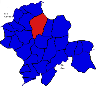
Rendufinho is a Portuguese Freguesia in the municipality of Póvoa de Lanhoso, it has an area of 8.86 km² and 736 inhabitants (2011). And a population density of 83.1 people per km².
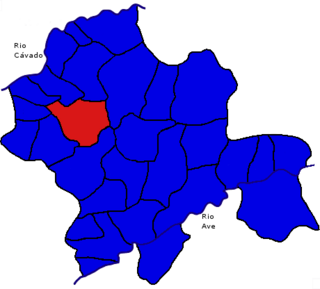
Geraz do Minho is a Portuguese Freguesia in the municipality of Póvoa de Lanhoso, it has an area of 4.33 km2 and 521 inhabitants (2011). It has a population density of 120 people per km2.

Sobradelo da Goma is a Portuguese Freguesia in the municipality of Póvoa de Lanhoso, it has an area of 10.23 km² and 794 inhabitants (2011). Its population density is 77.6 people per km².


