Related Research Articles

The geography of Mozambique consists mostly of coastal lowlands with uplands in its center and high plateaus in the northwest. There are also mountains in the western portion. The country is located on the east coast of southern Africa, directly west of the island of Madagascar. Mozambique has a tropical climate with two seasons, a wet season from October to March and a dry season from April to September.
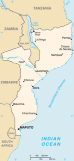
Modes of transport in Mozambique include rail, road, water, and air. There are rail links serving principal cities and connecting the country with Malawi, Zimbabwe and South Africa. There are over 30,000km of roads, but much of the network is unpaved.

Tanzania comprises many lakes, national parks, and Africa's highest point, Mount Kilimanjaro. Northeast Tanzania is mountainous, while the central area is part of a large plateau covered in grasslands. The country also contains the southern portion of Lake Victoria on its northern border with Uganda and Kenya.

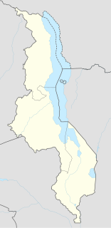
Malawi is a landlocked country in southeast Africa. It is wholly within the tropics; from about 9°30S at its northernmost point to about 17°S at the southernmost tip. The country occupies a thin strip of land between Zambia and Mozambique, extending southwards into Mozambique along the valley of the Shire River. In the north and north east it also shares a border with Tanzania. Malawi is connected by rail to the Mozambican ports of Nacala and Beira. It lies between latitudes 9° and 18°S, and longitudes 32° and 36°E.

Mulanje, formerly called Mlanje, is a town in the Southern Region of Malawi, close to the border with Mozambique, to the east. It is near the Mulanje Massif.

Nsanje is the main city in Nsanje District within the Southern Region of Malawi.

The Central Region of Malawi, population 7,523,340 (2018), covers an area of 35,592 km². Its capital city is Lilongwe, which is also the national capital. The region has an outlet on Lake Malawi and borders neighbouring countries Zambia and Mozambique. The Chewa people make up the majority of the population today.

Chipinge District is a district in Manicaland Province of Zimbabwe. The administrative headquarters is Chipinge.
Chiradzulu is a district in the Southern Region of Malawi. The capital is Chiradzulu. The district covers an area of 767 km.² and has a population of 236,050.
Mangochi District is one of twelve districts in the Southern Region of Malawi. The capital is Mangochi. The district covers an area of 6,273 km.² and has a population of 610,239.

Cuamba is a city and district of Niassa Province in Mozambique, lying north west of Mount Namuli. Before independence the town was known as Nova Freixo.
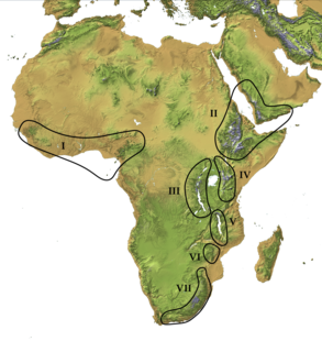
The Afromontane regions are subregions of the Afrotropical realm, one of the Earth's eight biogeographic realms, covering the plant and animal species found in the mountains of Africa and the southern Arabian Peninsula. The Afromontane regions of Africa are discontinuous, separated from each other by lower-lying areas, and are sometimes referred to as the Afromontane archipelago, as their distribution is analogous to a series of sky islands.
Morrumbala District is a district of Zambezia Province in Mozambique. The town of Morrumbala is the district headquarters.

Mount Namuli is the second highest mountain in Mozambique and the highest in the Province of Zambezia. It is 2,420 m (7,940 ft) high and was measured, surveyed and described in 1886 by Henry Edward O'Neill, the British consul in Mozambique. The Namuli massif consists of a level plateau with the granite dome of Mount Namuli above. The area was historically clad in tropical rainforest and is an important biodiversity hotspot with many endemic species of animals and plants. The lower slopes are now mainly used for the cultivation of tea and the middle slopes for other agricultural purposes, with indigenous forest now mostly restricted to the higher parts and corridors along water courses.
Chiperoni is a Malawian term for a kind of drizzle rain, experienced in the Shire Highlands of southern Malawi during the cold, dry season.

Ruo River is the largest tributary of the Shire River in southern Malawi and Mozambique. It originates from the Mulanje Massif (Malawi) and forms 80 km (50 mi) of the Malawi-Mozambique border. It joins the Shire River at Chiromo.
Mwanza is a town in Malawi on the border with Mozambique. It is the administrative headquarters for Mwanza District.

Mount Chiperone is a mountain in northern Mozambique.
Mount Tumbine is a mountain in northern Mozambique.
The Revolutionary Party of Mozambique was an armed rebel group in northern Mozambique during the Mozambican Civil War. Founded by Amos Sumane in 1974 or 1976, the PRM was strongly opposed to Mozambique's FRELIMO government and its communist ideology. The party waged a low-level insurgency in the provinces of Zambezia, Tete and Niassa from 1977. Sumane was captured in 1980 and executed by the Mozambican government in 1981. The PRM's leadership passed to Gimo Phiri under whom the party merged with another rebel group, RENAMO, in 1982.
References
- ↑ Timberlake, Jonathan; Julian Bayliss, Tereza Alves, Susana Baena, Jorge Francisco, Tim Harris, Camila da Sousa (2007). "The Biodiversity and Conservation of Mount Chiperone, Mozambique". Darwin Initiative Award 15/036: Monitoring and Managing Biodiversity Loss in South-east Africa's Montane Ecosystems. Accessed 22 June 2018.
| | This Mozambique location article is a stub. You can help Wikipedia by expanding it. |