
Malawi is a landlocked country in southeast Africa. It is wholly within the tropics; from about 9°30S at its northernmost point to about 17°S at the southernmost tip. The country occupies a thin strip of land between Zambia and Mozambique, extending southwards into Mozambique along the valley of the Shire River. In the north and north east it also shares a border with Tanzania. Malawi is connected by rail to the Mozambican ports of Nacala and Beira. It lies between latitudes 9° and 18°S, and longitudes 32° and 36°E.

Mulanje, formerly called Mlanje, is a town in the Southern Region of Malawi, close to the border with Mozambique, to the east. It is near the Mulanje Massif.

The Mulanje Massif, also known as Mount Mulanje, is a large inselberg in southern Malawi. Sapitwa Peak, the highest point on the massif at 3,002 m, is the highest point in Malawi. It lies 65 km east of Blantyre, rising sharply from the surrounding plains of Phalombe and the Mulanje district.

The Zomba Plateau, also called the Zomba Massif, is a mountain of the Shire Highlands in southern Malawi. Its total area is about 130 square kilometres (50 sq mi), with a highest point of 2,087 metres (6,847 ft).

Chambe Peak is a peak of Mulanje Massif, one of the highest mountains in Southern Africa, with an elevation of 3,002 meters (9,849 ft.). A steep path provides a great view across Southern Malawi and Mozambique on a clear day. The plateau on the top is part of the forest of Mulanje Cedar; Chambe also has a farm and living spaces in a hut run by the Forestry Commission in Malawi. Chambe is also the base for climbing the sheer cliff face; Chris Bonnington has detailed this in the record book at Chambe Hut. Proper rock climbing equipment is necessary for the ascent. Likubula Path is the common descent; although it can be ascended, it is more difficult and rocky than ascending from Chambe.
Muloza is a village in Malawi on the border with Mozambique. It is 20 miles south of Mulanje and the Mulanje Massif and is a significant source of the country's maize.

Mulanje Mountain Forest Reserve is a nature reserve founded in 1927 in Malawi. The reserve covers 56,317 hectares. It is operated by the Mulanje Mountain Conservation Trust. The reserve was designated a biosphere reserve by UNESCO in 2000.
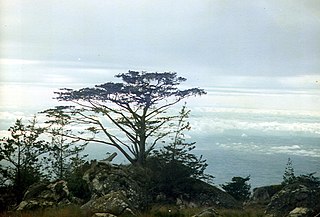
Widdringtonia whytei, the Mulanje cedar or Mulanje cypress, is a species of conifer native to Malawi, where it is endemic to the Mulanje Massif at altitudes of 1,830–2,550 m. It has become endangered as a result of over-harvesting for its wood, and an increase in the frequency of wildfires due to human activity.

Arthroleptis francei is a species of frog in the family Arthroleptidae. It is found in Mount Mulanje in southern Malawi and in Mount Namuli and Mount Mabu in northern Mozambique. Records from the Zomba Massif (Malawi) require confirmation. Common names Ruo River screeching frog and France's squeaker have been coined for it.

Hyperolius spinigularis is a species of frog in the family Hyperoliidae. It is found in the Mulanje Massif in southern Malawi and the Namuli Massif in adjacent Mozambique. Records from Tanzania refers to other species. Males of this species have characteristic small spines during the breeding season. Its common names are spiny-throated reed frog, spiny reed frog, and Mulanje reed frog.
Potamonautes choloensis is a species of freshwater crustacean in the family Potamonautidae.

Mount Namuli is the second highest mountain in Mozambique and the highest in the Province of Zambezia. It is 2,420 m (7,940 ft) high and was measured, surveyed and described in 1886 by Henry Edward O'Neill, the British consul in Mozambique. The Namuli massif consists of a level plateau with the granite dome of Mount Namuli above. The area was historically clad in tropical rainforest and is an important biodiversity hotspot with many endemic species of animals and plants. The lower slopes are now mainly used for the cultivation of tea and the middle slopes for other agricultural purposes, with indigenous forest now mostly restricted to the higher parts and corridors along water courses.

Republic of Malawi – sovereign country located in southeastern Africa. Malawi is bordered by Zambia to the northwest, Tanzania to the north and Mozambique, which surrounds it on the east, south and west and is separated from Malawi by Lake Malawi. The origin of the name Malawi is unclear; it is either derived from that of southern tribes, or from the "glitter of the sun rising across the lake". Malawi is a densely populated country with a democratically-elected, presidential system of government.
The South Malawi montane forest–grassland mosaic is an ecoregion of Malawi.
Ruo River is the largest tributary of the Shire River in southern Malawi and Mozambique. It originates from the Mulanje Massif (Malawi) and forms 80 km (50 mi) of the Malawi-Mozambique border. It joins the Shire River at Chiromo.
The geology of Malawi formed on extremely ancient crystalline basement rock, which was metamorphosed and intruded by igneous rocks during several orogeny mountain building events in the past one billion years. The rocks of the Karoo Supergroup and newer sedimentary units deposited across much of Malawi in the last 251 million years, in connection with a large rift basin on the supercontinent Gondwana and the more recent rifting that has created the East African Rift, which holds Lake Malawi. The country has extensive mineral reserves, many of them poorly understood or not exploited, including coal, vermiculite, rare earth elements and bauxite.
Mount Chiperone is a mountain in northern Mozambique.
Milange is a town in Zambezia Province of Mozambique. It is the district center of Milange District.
The Muloza–Chiringa Road is a road in the Southern Region of Malawi, connecting the towns of Muloza in Mulanje District, and Chiringa, in Phalombe District.
