MacKay Peak

Last updated
Location of Tangra Mountains on Livingston Island in the South Shetland Islands. Tangra-Mountains-location-map.png
Location of Tangra Mountains on Livingston Island in the South Shetland Islands.
MacKay (the conspicuous sharp peak in the background) from Willan Saddle. Huntress-Glacier.JPG
MacKay (the conspicuous sharp peak in the background) from Willan Saddle.
Topographic map of Livingston Island and Smith Island. Livingston-Island-Map-2010-15.png
Topographic map of Livingston Island and Smith Island.

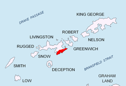
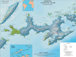
MacKay Peak is an ice-covered pyramidal peak rising to 770 m in Friesland Ridge, Tangra Mountains, Livingston Island in the South Shetland Islands, Antarctica. It is linked by Pleven Saddle to Tervel Peak to the east-northeast, and surmounts Peshtera Glacier to the north and Charity Glacier to the south.

Contents

The peak is named after Captain Donald MacKay, Master of the American shallop Sarah who, while seal hunting in the islands in 1820–21, sent home a collection of minerals and rocks to the New York Lyceum of Natural History, forerunner of the American Museum of Natural History.

Location

MacKay Peak from Atlantic Club Ridge. MacKay-Peak.JPG
MacKay Peak from Atlantic Club Ridge.

The peak is located at 62°43′16″S60°17′57.5″W / 62.72111°S 60.299306°W / -62.72111; -60.299306 which is 5.67 km south of Napier Peak, 3.62 km southwest of Kikish Crag, 2.76 km west-southwest of St. Methodius Peak and 2.41 km north-northeast of Veleka Peak (British mapping in 1968, and Bulgarian mapping in 2005 and 2009).

Maps

Related Research Articles

<span class="mw-page-title-main">Kaliakra Glacier</span> Glacier in Antarctica

Kaliakra Glacier is a glacier in northeastern Livingston Island, Antarctica extending 3.8 nautical miles in east-west direction and 4.3 nautical miles in north-south direction, and situated southeast of Saedinenie Snowfield, southwest of Panega Glacier, north of Struma Glacier and upper Huron Glacier, and northeast of Perunika Glacier. It is bounded by Melnik Ridge and Bowles Ridge to the south, by Hemus Peak, Gurev Gap, Gleaner Heights, Elhovo Gap, Leslie Hill, Leslie Gap and Radnevo Peak to the west, and Miziya Peak and Samuel Peak to the north. The glacier drains eastwards into Moon Bay south of Perperek Knoll and north of Sindel Point.

<span class="mw-page-title-main">Levski Ridge</span> In the Tangra Mountains, in Livingston Island, Antarctica

Levski Ridge is the central ridge of the Tangra Mountains, Livingston Island. Its summit, Great Needle Peak rises to 1,680m and is the second highest summit of the island after Mount Friesland.

<span class="mw-page-title-main">Magura Glacier</span> Glacier in Antarctica

Magura Glacier on the southeast side of Tangra Mountains on Livingston Island in the South Shetland Islands, Antarctica is located to the north of M'Kean Point, northeast of Srebarna Glacier, south of Iskar Glacier and southwest of Dobrudzha Glacier. It is bounded by Great Needle Peak to the west, Vitosha Saddle, Vihren Peak and Helmet Peak to the northwest, Plovdiv Peak and Shishman Peak to the north, and Devin Saddle and Kuber Peak to the northeast. The glacier extends 3.5 km in southwest-northeast direction and 1.9 km in northwest-southeast direction, and flows southeastward into Bransfield Strait.

<span class="mw-page-title-main">Musala Glacier</span> Glacier located in Antarctica

Musala Glacier on Greenwich Island in the South Shetland Islands, Antarctica is situated northeast of Targovishte Glacier, east-northeast of Zheravna Glacier and southeast of Fuerza Aérea Glacier. It is bounded by St. Kiprian Peak to the south, Vratsa Peak to the southwest, central Breznik Heights to the west, and Ilarion Ridge bordering Hardy Cove to the northeast, extends 2 nautical miles in east-west direction and 1.2 nautical miles in north-south direction, and drains eastwards into Bransfield Strait north of Fort Point.

<span class="mw-page-title-main">Orpheus Gate</span>

Orpheus Gate, also Orpheus Pass, is the 548 m high and 380 m wide pass in eastern Livingston Island in the South Shetland Islands, Antarctica, bounded by Pliska Ridge on the southeast and Polanco Peak in Burdick Ridge on the northwest, Huntress Glacier on the southwest and Perunika Glacier on the northeast.

<span class="mw-page-title-main">Perunika Glacier</span> Glacier in Antarctica

Perunika Glacier is an 8 km long and 3 km wide (average) roughly crescent-shaped glacier in eastern Livingston Island in the South Shetland Islands, Antarctica situated east of Pimpirev Glacier, south of Saedinenie Snowfield, southwest of Kaliakra Glacier, west of Huron Glacier, and north of Balkan Snowfield and the head of Huntress Glacier.

<span class="mw-page-title-main">Peshtera Glacier</span> Glacier in Antarctica

The Peshtera Glacier is a glacier on the Rozhen Peninsula, Livingston Island in the South Shetland Islands, Antarctica situated southwest of Ruen Icefall and north of Charity Glacier.

<span class="mw-page-title-main">Pliska Ridge</span> Three-peaked ridge in the South Shetland Islands, Antarctica

Pliska Ridge is a three-peaked ridge rising to 667 m (2,188 ft) in eastern Livingston Island in the South Shetland Islands, Antarctica. Its central and highest summit, Pliska Peak, is located 2.48 km (1.54 mi) east-northeast of Willan Nunatak, 1.81 km (1.12 mi) southeast of Burdick Peak, 3.53 km (2.19 mi) south-southwest of Mount Bowles, 3.68 km (2.29 mi) west-southwest of Kuzman Knoll, and 3.61 km (2.24 mi) northwest of Mount Friesland. The feature is 1.6 km (0.99 mi) long and 500 m (1,600 ft) wide, its axis trending due east-west, with precipitous southern slopes. It is ice-covered except for segments of its easternmost peak and is bounded to the northwest by Orpheus Gate, to the north by the head of Perunika Glacier, to the east by Nesebar Gap, and to the south and west by the head of Huntress Glacier, the latter flowing 6 km (3.7 mi) southwestwards into False Bay.

<span class="mw-page-title-main">Prespa Glacier</span> Glacier in Antarctica

Prespa Glacier on Rozhen Peninsula, Livingston Island in the South Shetland Islands, Antarctica is situated east-northeast of Tarnovo Ice Piedmont, east of the head of Charity Glacier, southeast of Ruen Icefall and southwest of Macy Glacier. It is bounded to the east by Needle Peak and Ludogorie Peak, to the northwest by St. Cyril Peak and St. Methodius Peak, and to the southwest by Shumen Peak and Yambol Peak, and flows southeastward into Bransfield Strait between Gela Point and Samuel Point. The feature extends 3.5 km in east-west direction and 2.5 km in north-south direction. The glacier is named after Prespa Peak in the Rhodope Mountains, Bulgaria.

<span class="mw-page-title-main">Radomir Knoll</span>

Radomir Knoll rises to approximately 300 m in Prespa Glacier, eastern Livingston Island in the South Shetland Islands, Antarctica. It is formed by the south extremity of an offshoot of Friesland Ridge, Tangra Mountains that extends to the south-southeast from St. Cyril Peak and surmounts Chavei Cove to the south and southwest.

<span class="mw-page-title-main">Srebarna Glacier</span> Glacier in Antarctica

Srebarna Glacier on Livingston Island in the South Shetland Islands, Antarctica is situated east-northeast of Boyana Glacier, southeast of the head of Macy Glacier and southwest of Magura Glacier. It extends 2.3 km in southwest-northeast direction and 1.8 km in northwest-southeast direction, and drains southeast of Serdica Peak and the Great Needle Peak in Levski Ridge, Tangra Mountains to enter Bransfield Strait between Aytos Point and M'Kean Point.

<span class="mw-page-title-main">Tervel Peak</span>

Tervel Peak is a triple peak rising to 810 m in Friesland Ridge, Tangra Mountains on Livingston Island in the South Shetland Islands, Antarctica overlooking Peshtera Glacier and Zagore Beach to the northwest, and Charity Glacier to the southwest. Linked by Pleven Saddle to MacKay Peak in the west-southwest.

<span class="mw-page-title-main">Tundzha Glacier</span> Glacier in Antarctica

Tundzha Glacier is a glacier on Livingston Island in the South Shetland Islands, Antarctica situated east-southeast of Berkovitsa Glacier, west of Saedinenie Snowfield, northwest of Pimpirev Glacier, north of Kamchiya Glacier, and east-northeast of Verila Glacier. It is bounded by Snow Peak to the west, Teres Ridge to the east and the glacial divide between the Drake Passage and Bransfield Strait to the south. The glacier extends 7.5 nautical miles in east-west direction and 2.4 nautical miles in the north-south direction, and drains northwards into Hero Bay between Avitohol Point and Siddins Point.

<span class="mw-page-title-main">Wulfila Glacier</span> Glacier in Antarctica

Wulfila Glacier is located on the southern slopes of Breznik Heights, Greenwich Island in the South Shetland Islands, Antarctica, south-southwest of Solis Glacier and west of Zheravna Glacier. It is bounded by Oborishte Ridge to the northwest, Nevlya Peak to the north, Terter Peak and Razgrad Peak to the northeast, and Ephraim Bluff to the southeast. The glacier extends 3 km in northwest–southeast direction and 2 km in northeast–southwest direction. It drains southwestwards into McFarlane Strait between Ephraim Bluff and the base of Provadiya Hook, feeding the head of Doris Cove.

<span class="mw-page-title-main">Yambol Peak</span>

Yambol Peak is a rocky peak rising to 300 m in the south extremity of Friesland Ridge, Tangra Mountains on Livingston Island in the South Shetland Islands, Antarctica and overlooking Tarnovo Ice Piedmont to the west and Prespa Glacier to the northeast. The ice-free surface area of the peak is 33 hectares. A southeastern offshoot of the peak forms Gela Point. The feature is named after the Bulgarian town of Yambol.

<span class="mw-page-title-main">Bowles Ridge</span> Central ridge of eastern Livingston Island

Bowles Ridge is the central ridge of eastern Livingston Island. The ridge extends 6.5 km in the east-west direction and is 1.5 km wide. The summit of the ridge is Mount Bowles which rises to 822m and is located 9.77 km northwest of Great Needle Peak, 6.08 km north by west of Mount Friesland, 8.77 km east-northeast of St. Kliment Ohridski base and 9.25 km south by west of Miziya Peak.

<span class="mw-page-title-main">Willan Nunatak</span>

Willan Nunatak is an ice-free tipped peak rising to 449 m on the glacial divide between Huntress Glacier and Balkan Snowfield on Hurd Peninsula in eastern Livingston Island in the South Shetland Islands, Antarctica. It is linked to Burdick South Peak to the northeast by Willan Saddle and, via Castillo Nunatak and Charrúa Gap, to Charrúa Ridge to the west.

<span class="mw-page-title-main">Johnsons Glacier</span>

Johnsons Glacier is the 1.8 km long and 2.3 km wide glacier on Hurd Peninsula, Livingston Island in the South Shetland Islands, Antarctica bounded by Charrúa Ridge and Charrúa Gap to the north, Napier Peak to the east, Mirador Hill to the southeast, Hurd Ice Cap to the southwest and Mount Reina Sofía to the west. It is draining northwestwards into Johnsons Dock. The glacier provides overland access from the Spanish base Juan Carlos Primero to the interior of the eastern Livingston Island.

<span class="mw-page-title-main">Mount Reina Sofía</span> Peak on Livingston Island, Antarctica

Mount Reina Sofía is the mostly ice-free peak rising to 275 m on Hurd Peninsula, Livingston Island in the South Shetland Islands, Antarctica and surmounting Johnsons Glacier to the east and northeast, and the Spanish Antarctic base Juan Carlos Primero to the north-northwest.

<span class="mw-page-title-main">Glaciar Rocoso Cove</span>

Glaciar Rocoso Cove is a small open cove, part of False Bay, Livingston Island in the South Shetland Islands, Antarctica. It is 920 m wide and indenting for 180 m the southeast coast of Hurd Peninsula east-northeast of Binn Peak and south-southwest of Nusha Hill. The area was visited by early 19th century sealers.

References