Tomb WV22, also known as KV22, was the burial place of the Eighteenth Dynasty pharaoh Amenhotep III. Located in the Western arm of the Valley of the Kings, the tomb is unique in that it has two subsidiary burial chambers for the pharaoh's wives Tiye and Sitamen. It was officially discovered by Prosper Jollois and Édouard de Villiers du Terrage, engineers with Napoleon's expedition to Egypt in August 1799, but had probably been open for some time. The tomb was first excavated by Theodore M. Davis, the details of which are lost. The first documented clearance was carried out by Howard Carter in 1915. Since 1989, a Japanese team from Waseda University led by Sakuji Yoshimura and Jiro Kondo has excavated and conserved the tomb. The sarcophagus is missing from the tomb. The tomb's layout and decoration follow the tombs of the king's predecessors, Amenhotep II (KV35) and Thutmose IV (KV43); however, the decoration is much finer in quality. Several images of the pharaoh's head have been cut out and can be seen today in the Louvre.
Tomb KV47, located in the Valley of the Kings in Egypt, was used for the burial of Pharaoh Siptah of the Nineteenth Dynasty. It was discovered on December 18, 1905 by Edward R. Ayrton, excavating on behalf of Theodore M. Davis; Siptah's mummy had been found earlier, cached in KV35. It was the last of the Nineteenth and Twentieth Dynasty kings tombs to be uncovered in the Valley. Ayrton stopped his excavation in 1907 due to safety fears, and Harry Burton returned in 1912 to dig further. The cutting of a side passage was halted after the workmen cut into Side Chamber Ja of the tomb of Tia'a (KV32). The tomb was unfinished at the time of its use.

The pyramid of Khendjer was a pyramid built for the burial of the 13th dynasty pharaoh Khendjer, who ruled Egypt c. 1760 BC during the Second Intermediate Period. The pyramid, which is part of larger complex comprising a mortuary temple, a chapel, two enclosure walls and a subsidiary pyramid, originally stood around 37 m (121 ft) high and is now completely ruined. The pyramidion was discovered during excavations under the direction of Gustave Jéquier in 1929, indicating that the pyramid was finished during Khendjer's lifetime. It is the only pyramid known to have been completed during the 13th Dynasty.

A Mycenaean chamber tomb is the type of chamber tomb that was built in Mycenaean Greece. Mycenaean chamber tombs originated in Messenia at the end of the Middle Helladic period, and were built and used throughout the Late Bronze Age across the Aegean area.
The Züschen tomb is a prehistoric burial monument, located between Lohne and Züschen, near Fritzlar, Hesse, Germany. Classified as a gallery grave or a Hessian-Westphalian stone cist, it is one of the most important megalithic monuments in Central Europe. Dating to the late 4th millennium BC, it belongs to the Late Neolithic Wartberg culture. The presence of incised carvings, comparable to prehistoric rock art elsewhere in Europe, is a striking feature of Wartberg culture tombs, known so far only from Züschen and from tomb I at Warburg.
The Lohra tomb was a megalithic monument outside Lohra near Marburg in north central Hesse, Germany. It is one of the lesser known among its type in Central Europe. It dates to the late Neolithic, probably just after 3000 BC. It belongs to the gallery graves of the Wartberg culture, but is unique among them because of its rich ceramic assemblage.

The Qianling Mausoleum is a Tang dynasty (618–907) tomb site located in Qian County, Shaanxi province, China, and is 85 km (53 mi) northwest from Xi'an. Built in 684, the tombs of the mausoleum complex house the remains of various members of the House of Li, the imperial family of the Tang dynasty. This includes Emperor Gaozong, as well as his wife, Wu Zetian, who assumed the Tang throne and became China's only reigning female emperor from 690–705. The mausoleum is renowned for its many Tang dynasty stone statues located above ground and the mural paintings adorning the subterranean walls of the tombs. Besides the main tumulus mound and underground tomb of Emperor Gaozong and Wu Zetian, there are 17 smaller attendant tombs, or peizang mu. Presently, only five of these attendant tombs have been excavated by archaeologists, three belonging to members of the imperial family, one to a chancellor, and the other to a general of the left guard. The Shaanxi Administration of Cultural Heritage declared in 2012 that no further excavations would take place for at least 50 years.

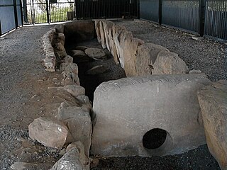
The Tombs of the Kings are a rock-cut funerary complex in East Jerusalem believed to be the burial site of Queen Helene of Adiabene, hence: Helena's Monuments. The tombs are located 820 meters north of Jerusalem's Old City walls in the Sheikh Jarrah neighborhood

The Illyrian Tombs of Selca e Poshtme are located near the town of Pogradec in Albania near the village of Selcë e Poshtme. On the right bank of the river Shkumbin at an elevation of 1040 m above sea level, lie the remains of the ancient city of Pelion and the accompanying necropolis. The Roman Via Egnatia led past it towards Thessaloniki. Though there are traces of human activity in Neolithic times, the settlement proper dates to the Iron Age through to the Illyrian urban period, and reached its height under settlement by the Illyrian tribe of Enchele in the later Iron Age and was also occupied in the Roman period as traces of a municipal building show. From the 4th to 1st centuries BC the city was the royal residence of Illyrian kings and therefore, also probably an important political and economic centre. In 1996, Albania included the Royal tombs of Selca e Poshtme in the UNESCO World heritage list of proposals.

The Aleksandrovo tomb is a Thracian burial mound and tomb excavated near Aleksandrovo, Haskovo Province, South-Eastern Bulgaria, dated to c. 4th century BCE.

Tombs of the Sanhedrin, also Tombs of the Judges, is an underground complex of 63 rock-cut tombs located in a public park in the northern Jerusalem neighborhood of Sanhedria. Built in the 1st century CE, the tombs are noted for their elaborate design and symmetry. They have been a site for Jewish pilgrimage since the medieval period. The popular name of the complex, which has the most magnificently carved pediment of ancient Jerusalem, is due to the fact that the number of burial niches it contains is somewhat close to that of the members of the ancient Jewish supreme court, the Great Sanhedrin, namely 71.

Golyama Arsenalka mound is a Thracian burial tumulus with a subterranean stone building near the Bulgarian town of Shipka. It dates from the end of 5th century BCE.

The Necropolis of Soderstorf is a prehistoric cemetery in the valley of the Luhe river valley near Soderstorf in the Lüneburg district of Lower Saxony, Germany. The site was used for more than 2000 years. It includes a megalithic tomb, a tumulus tomb, a stone circle, paving stones, funerary urns and a flat grave.

The Kasta Tomb, also known as the Amphipolis Tomb, is the largest ancient tumulus ever discovered in Greece, and by comparison dwarfs that of Philip II of Macedon, father of Alexander the Great, in Vergina.

Pydna is an ancient Greek city in the regional unit of Pieria, Central Macedonia, Greece. It is an important place in the history of Pieria and a major archaeological site located directly at the Aegean Sea, 16 km northeast of Katerini, 28 km north-east of Dion and 2.5 km from the village of Makrygialos. Nearby are two Macedonian tombs, discovered by the French archaeologist Heuzey during his Greek travels in the mid-19th century. Furthermore, the fortress-like bishop's seat Louloudies is located a few kilometers south of Pydna.

Ancient Methone, also called Thracian or Macedonian Methone to distinguish it from Messenian Methone was a polis in Ancient Greece, near the city of Pydna and the modern village of Nea Agathoupolis in Pieria. According to Plutarch, Methone was founded as a Greek colony in the year 733/732 BC. Methone gained special importance by the finding of labeled pottery and potsherds. It is one of the oldest testimonies of Greek writing and an important place in the history of Pieria.

At works to recover clay, two Macedonian tombs were discovered north of Katerini.

This is a reflection of the main historical events in Pieria (Πιερία), Central Macedonia.
There are some Macedonian tombs and the necropolises of Pydna around ancient Pydna and beside the ancient road from Methone in the north to Dion in the south. The oldest tombs are from the Bronze Age; the youngest are from the early Christian period. Smaller tumuli have eroded over time and are no longer visible. Most excavations have had to be carried out to save the sites. The finds in both areas show a shrinking population during the second Greek colonization.
Pigi Artemidos is a Bronze Age settlement.


