Related Research Articles

Pasquotank County is a county located in the U.S. state of North Carolina. As of the 2010 census, the population was 40,661. Its county seat is Elizabeth City. The county was originally created as Pasquotank Precinct and gained county status in 1739.

Hyde County is a county located in the U.S. state of North Carolina. As of the 2010 Census, the population was 5,810, making it the second-least populous county in North Carolina. Its county seat is Swan Quarter. The county was created in 1705 as Wickham Precinct. It was renamed Hyde Precinct in 1712 and gained county status in 1739.

Newport is a town in Carteret County, North Carolina, United States. The population was 4,510 at the 2010 census.
Reamstown is an unincorporated community and census-designated place (CDP) in Lancaster County, Pennsylvania, United States. The population was 3,361 at the 2010 census.
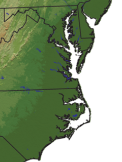
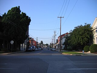
Tidewater is a reference to the north Atlantic coastal plain region of the United States of America.

Albemarle Sound is a large estuary on the coast of North Carolina in the United States located at the confluence of a group of rivers, including the Chowan and Roanoke. It is separated from the Atlantic Ocean by the Currituck Banks, a barrier peninsula upon which the town of Kitty Hawk is located, at the eastern edge of the sound, and part of the greater Outer Banks region. Roanoke Island is situated at the southeastern corner of the sound, where it connects to Pamlico Sound. Much of the water in the Albemarle Sound is brackish or fresh, as opposed to the saltwater of the ocean, as a result of river water pouring into the sound.

The Abitibi River is a river in northeastern Ontario, Canada, which flows northwest from Lake Abitibi to join the Moose River which empties into James Bay. This river is 540 kilometres (340 mi) long, and descends 265 metres (869 ft).

CSSSea Bird was a sidewheel steamer in the Confederate States Navy.

The Dismal Swamp Canal is located along the eastern edge of the Great Dismal Swamp in Virginia and North Carolina in the United States. It is the oldest continually operating man-made canal in the United States, opened in 1805. It is part of the Intracoastal Waterway.
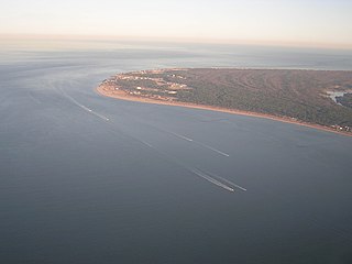
Cape Henry is a cape on the Atlantic shore of Virginia located in the northeast corner of Virginia Beach. It is the southern boundary of the entrance to the long estuary of the Chesapeake Bay.

The Pasquotank River is a coastal water-body in Northeastern North Carolina in the United States. Located between Camden and Pasquotank counties, the Pasquotank connects directly to the Albemarle Sound and is part of the Intracoastal Waterway via Elizabeth City.

The Nottoway River is a river in the U.S. State of Virginia and northeastern North Carolina that is 155 miles in length. It begins in Prince Edward County and flows to create the Chowan River. The river is part of the Chowan River system, which flows into Albemarle Sound in North Carolina.

The Chowan River is a blackwater river formed with the merging of Virginia's Blackwater and Nottoway rivers near the stateline between Virginia and North Carolina. According to the USGS a variant name is Choan River.
The Meherrin River is a 92-mile (148 km) long river in the U.S. states of Virginia and North Carolina. It begins in central Virginia, about 50 miles (80 km) northwest of Emporia, and flows roughly east-southeast into North Carolina, where it joins the larger Chowan River.
Black Warrior is the name of a Confederate two-masted schooner that participated in the defense of Roanoke Island in North Carolina during the Civil War. Its brief wartime career ended with its burning at Elizabeth City, North Carolina.
WWIN is an urban gospel formatted radio station in Baltimore, Maryland, United States. Owned by Urban One, the station's transmitter is located in the Orangewood section of east Baltimore, and its studios are located in Woodlawn.
The Southern Branch Elizabeth River is a 14.5-mile-long (23.3 km), primarily tidal river in the U.S. state of Virginia. It flows from south to north through the city of Chesapeake and forms the boundary between the cities of Portsmouth and Chesapeake for its northernmost 3 miles (5 km). It is a tributary of the Elizabeth River, connecting to the harbor of Hampton Roads to the north. It is part of the Intracoastal Waterway of the Atlantic coast of the United States, connecting by it to the North Landing River, which flows into North Carolina.
Peacock Island is the smallest of the four islands owned by Stratford, Connecticut in the Housatonic River between I-95 and the Merritt Parkway. The island is north of the Moses Wheeler Bridge, west of Carting Island, southwest of Long Island (Connecticut), Pope's Flat, and south of Fowler Island in Milford and the Igor I. Sikorsky Memorial Bridge. The island is uninhabited except for occasional visits by anglers, bird watchers and duck hunters.

Redart is an unincorporated community in Mathews County, in the U. S. state of Virginia. The name is a reversal of Trader, the name of an early settler.
Prior is an unincorporated community in Douglas County, Missouri, United States. The community is located on Missouri Route 95, just north of the intersection with Missouri Route 76 and 2.5 miles north of Vanzant. The community sits on a ridge between Fox Creek to the west and Clifty Creek to the east, at an elevation of 1,243 ft (379 m).
References
- ↑ U.S. Geological Survey Geographic Names Information System: Machelhe Island
- ↑ Lacey, Theresa Jensen (1 October 2002). Amazing North Carolina. Thomas Nelson Inc. p. 44. ISBN 978-1-4185-3840-8.
Coordinates: 36°18′06″N76°12′43″W / 36.30167°N 76.21194°W