Mackensen is a village of about 450 inhabitants which is incorporated into the city of Dassel (Northeim district, Germany) since 1974.
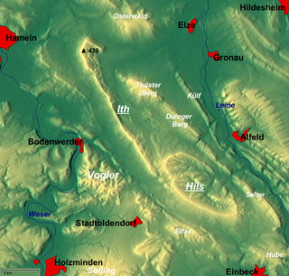
This village lies at the east side of the Solling mountains. The name Mackensen is a derivation of Makkonhusun, which in medieval times in the eastphalian language meant: village of a man named Makko.
It was mentioned in a written list of Corvey Abbey in the 9th century. In the Middle Ages, it was a part of the Suilbergau district, their men being ministeriales of the Counts of Dassel, who lived on the nearby Hunnesrück castle. Today Mackensen is located at the political border between the district of Northeim and the district of Holzminden (that border goes through a nearby hill named Heukenberg). In medieval times, Mackensen was located at a border, too, when it belonged to the Bishopric of Hildesheim, because the neighbouring territory of the Principality of Brunswick-Wolfenbüttel began nearby. Therefore, people constructed a church in their village devoted to Saint Christopher (patron of travellers) so that travellers could pray in that church before they continued their journey.
Coat of arms shows an ear and a two-handled hand saw on green background. These symbols remind that people were dependent from agriculture and the Solling woods in their history.
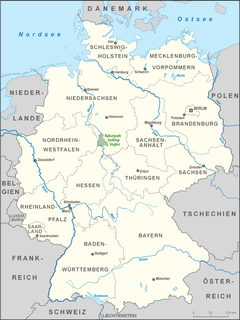
Northeim is a district in Lower Saxony, Germany. It is bounded by the districts of Holzminden, Hildesheim, Goslar and Göttingen, and the state of Hesse.
Dassel is a town in southern Lower Saxony, Germany, located in the district Northeim. It is located near the hills of the Solling mountains.
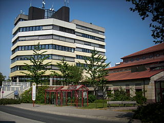
Northeim is a town in Lower Saxony, Germany, seat of the district of Northeim, with, in 2011, a population of 29,000. It lies on the German Half-Timbered House Road.
Bodenfelde is a municipality in the district of Northeim, in Lower Saxony, Germany. It is situated on the right bank of the Weser, approx. 35 km north of Kassel, and 30 km northwest of Göttingen at the southwest border of the Solling-Vogler Nature Park.
Nörten-Hardenberg is a municipality in the district of Northeim, in Lower Saxony, Germany.
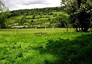
Llanwenarth is a small village and parish in the Usk Valley of Monmouthshire, south-east Wales, United Kingdom. It is in the community of Llanfoist Fawr and covered by the electoral ward of Llanwenarth Ultra.
Chuprene is a village in northwestern Bulgaria, part of Vidin Province. It is the administrative centre of the homonymous Chuprene Municipality, which lies in the southern part of Vidin Province. The village is located 20 kilometres from Belogradchik and 70 kilometres from Vidin, 13-15 kilometres from the Bulgarian-Serbian border.
Ostrów Warcki is a village in the administrative district of Gmina Warta, within Sieradz County, Łódź Voivodeship, in central Poland. It lies approximately 14 kilometres (9 mi) north of Warta, 25 km (16 mi) north of Sieradz, and 56 km (35 mi) west of the regional capital Łódź.
The Hils is a range of hills in Germany's Central Uplands that is up to 480.4 m high. It is located in the districts of Holzminden, Hildesheim and Northeim, in the state of Lower Saxony.
The Leine Uplands is a region in Germany's Central Uplands which forms a part of the Lower Saxon Hills and lies along the River Leine between Göttingen and Hanover. It borders on the Weser Uplands in the west, the Innerste Uplands in the northeast, the Harz in the east and Untereichsfeld in the southeast.
The Ahlsburg is a range of bunter sandstone hills, relatively small in area and up to 411.4 m above sea level (NN), in the southern part of Lower Saxony, Germany. It lies within the Solling foreland and is part of the Weser-Leine Uplands.
The Solling-Vogler Nature Park is a nature park in South Lower Saxony in Germany. It has an area of 52,000 hectares (200 sq mi) and was established in 1966.
The County of Dassel emerged shortly after the turn of the 11th and 12th centuries when, after the extinction of the male line of the Billungs, its seat in Suilbergau, north of the Solling hills was divided into the domains of Einbeck and Dassel. Reinold of Dassel was able to secure rights similar to comital rights. The county lasted about 200 years, till it was abandoned in 1310 when there were no heirs. The most prominent member of the comital family was Rainald of Dassel, chancellor to Emperor Frederick Barbarossa and Archbishop of Cologne.
Nienover is a rural housing estate which is part of Bodenfelde. It is located in the Solling and contains one of the largest deserted medieval towns in northern Europe.
Suilbergau, also known as Suilbergi, and Sülberggau, was an early medieval county in the province of Eastphalia, in the Duchy of Saxony.
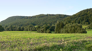
The Amtsberge are a relatively small ridge, up to 392.2 m above sea level (NN),
near Dassel in southern Lower Saxony in Germany.
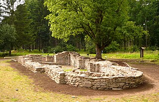
Hunnesrück Castle was a hilltop castle built in the 13th century. Its ruins are located in the Amtsberge hills near Dassel in the district of Northeim in south Lower Saxony in Germany.
Fredelsloh Abbey is a former monastery in Fredelsloh, district Northeim, Germany.
Hunnesrück is a suburb of Dassel, district Northeim, Lower Saxony.
Winnefeld is an abandoned village in the district of Northeim in Lower Saxony, Germany.
This page is based on this Wikipedia article Text is available under the CC BY-SA 4.0 license; additional terms may apply. Images, videos and audio are available under their respective licenses.