Falmouth is a town in Cumberland County, Maine, United States. The population was 12,444 at the 2020 census. It is part of the Portland–South Portland–Biddeford, Maine metropolitan statistical area.

Westbrook is a city in Cumberland County, Maine, United States and a suburb of Portland. The population was 20,400 at the 2020 census, making it the fastest-growing city in Maine between 2010 and 2020. It is part of the Portland–South Portland–Biddeford, Maine metropolitan statistical area.

Windham is a town in Cumberland County, Maine, United States. The population was 18,434 at the 2020 census. It includes the villages of South Windham and North Windham. It is part of the Portland–South Portland–Biddeford, Maine Metropolitan Statistical Area.

Sebago Lake (Sih-Bay-Goh) is the deepest and second-largest lake in the U.S. state of Maine. The lake is 316 feet (96 m) deep at its deepest point, with a mean depth of 101 feet (31 m). It is possible that Sebago is the deepest lake wholly contained within the entire New England region, although some sources say that Vermont's Lake Willoughby is slightly deeper. Along with Lake Champlain, Sebago is one of the only lakes in the area that does not consistently freeze solid during the winter months, with total ice cover only occurring for a short period of time every few winters. Sebago covers about 45 square miles (117 km2) in surface area, has a length of 14 miles (23 km) and has a shoreline length of roughly 105 miles (169 km). The surface is around 270 feet (82 m) above sea level, so the deep bottom is below the present sea level. It is in Cumberland County, and bordered by the towns of Casco, Naples, Raymond, Sebago, Standish and Windham. The seasonally occupied town of Frye Island is on an island in the lake. Sebago Lake and the surrounding area is known for its erratic and sudden changes in weather during all seasons, likely due to its proximity to the Atlantic Ocean and to Mt. Washington, a very notorious extreme weather hotspot. The name comes from the Abenaki sobagoo, meaning "it is the sea" or "it resembles the sea".

U.S. Route 302 is an east–west spur of U.S. Route 2 in northern New England in the United States. It currently runs 171 miles (275 km) from Montpelier, Vermont, beginning at US 2, to Portland, Maine, at U.S. Route 1. It passes through the states of Vermont, New Hampshire and Maine.

State Route 35 (SR 35) runs the course of western Maine, from Kennebunk to Bethel. It passes through Oxford, Cumberland and York, Cumberland, and Oxford counties. It is known in its lower sections for both its unusually windy course as well as its notoriously poor paving, as a result of winter frost heaves. Its northern section leads to the famous ski resort, Sunday River. The route crosses the Presumpscot River and a well-preserved section of the Cumberland and Oxford Canal approximately one mile (1.6 km) west of U.S. Route 302 (US 302) in North Windham.

U.S. Route 1 (US 1) in the U.S. state of Maine is a major north–south U.S. Route serving the eastern part of the state. It parallels the Atlantic Ocean from New Hampshire north through Portland, Brunswick, and Belfast to Calais, and then the St. Croix River and the rest of the Canada–United States border via Houlton to Fort Kent. The portion along the ocean, known as the Coastal Route, provides a scenic alternate to Interstate 95 (I-95).

South Windham is a census-designated place (CDP) in the town of Windham in Cumberland County, Maine, United States. The population of the CDP was 1,374 at the 2010 census. Prior to 2010, South Windham was part of the Little Falls-South Windham census-designated place.
The Piscataqua River is an 11.9-mile-long (19.2 km) tributary of the Presumpscot River in the U.S. state of Maine. Via the Presumpscot River, it is part of the watershed of Casco Bay, an arm of the Atlantic Ocean.

The Pleasant River is a 13.1-mile-long (21.1 km) tributary of the Presumpscot River in the U.S. state of Maine.

The Sheepscot River is a 66-mile-long (106 km) river in the U.S. state of Maine. Its lower portion is a complex island estuary with connections to the Kennebec River downstream of Merrymeeting Bay.
Portland, Maine, is home to many neighborhoods.

Martin's Point is a promontory in Portland, Maine, United States. It is located on the southern side of the Presumpscot River, at its confluence with Casco Bay, in the East Deering neighborhood of the city.

Yarmouth is a town in Cumberland County, Maine, United States, twelve miles north of the state's largest city, Portland. When originally settled in 1636, as North Yarmouth, it was part of the Massachusetts Bay Colony, and remained part of its subsequent incarnations for 213 years. In 1849, twenty-nine years after Maine's admittance to the Union as the twenty-third state, it was incorporated as the Town of Yarmouth.

Little Falls is a census-designated place (CDP) in the town of Gorham in Cumberland County, Maine, United States. The population of the CDP was 708 at the 2010 census. Prior to 2010, Little Falls was part of the Little Falls-South Windham census-designated place.

Babb's Bridge is a covered bridge spanning the Presumpscot River on Hurricane Road, between the towns of Gorham and Windham in Cumberland County, Maine. Built in 1976, it is a replica of a 19th-century bridge that stood on the site until destroyed by arson in 1973. The bridge was listed on the National Register of Historic Places in 1972, and was delisted in 2023.

State Route 144 (SR 144) is part of Maine's system of numbered state highways, located in Lincoln County along the state's southern coast. The southern terminus is at West Shore Road in Westport Island and the northern terminus is at U.S. Route 1 (US 1) in Wiscasset.

The Marine Hospital is a historic medical facility at 331 Veranda Road on Martin's Point in Portland, Maine. Built in the late 1850s to a design by Ammi B. Young, it is the only known surviving Marine Hospital of the period to retain original iron railings. The building is now part of the Portland campus of the Martin's Point Health Care medical practice. It was listed on the National Register of Historic Places in 1974.

Portland Street is a historic street in Yarmouth, Maine, United States. It runs for about 1.25 miles (2.01 km) from the town's Main Street, State Route 115, in the north to its merge with Middle Road in the south. It is so named because it leads to Portland, the state's largest city, after linking up with State Route 9 in Falmouth, Maine.

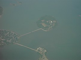
Martin's Point Bridge spans the Presumpscot River in Maine, United States, near the river’s mouth with Casco Bay. It connects Falmouth Foreside, at Mackworth Point, in the north, to the East Deering neighborhood of Portland, at Martin's Point, in the south. 1,300 feet (400 m) in length, it carries vehicular and pedestrian traffic of U.S. Route 1. The bridge is two lanes, including a bicycle lane in each, with a pedestrian lane on the eastern side. A similar plan for the western side of the bridge was abandoned.