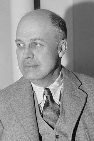
Edward Hopper was an American realist painter and printmaker. While he is widely known for his oil paintings, he was equally proficient as a watercolorist and printmaker in etching.

The Battle of Plattsburgh, also known as the Battle of Lake Champlain, ended the final British invasion of the northern states of the United States during the War of 1812. Two British forces, an army under Lieutenant General Sir George Prévost and a naval squadron under Captain George Downie converged on the lakeside town of Plattsburgh, New York. Plattsburgh was defended by New York and Vermont militia and detachments of regular troops of the United States Army, all under the command of Brigadier General Alexander Macomb, and ships commanded by Master Commandant Thomas Macdonough.

Coogan's Bluff is a promontory near the western shore of the Harlem River in the Washington Heights neighborhood of Upper Manhattan in New York City. Its boundaries extend approximately from 155th Street and the Macombs Dam Bridge viaduct to 160th Street, between Edgecombe Avenue and the river. A deep escarpment descends 175 feet (53 m) from Edgecombe Avenue to the river, creating a sheltered area between the bluff and river known as Coogan's Hollow. For 73 years, the hollow was home to the Polo Grounds sports stadium.

Highbridge is a residential neighborhood geographically located in the central-west section of the Bronx, New York City. Its boundaries, starting from the north and moving clockwise, are the Cross-Bronx Expressway to the north, Jerome Avenue to the east, Macombs Dam Bridge to the south, and the Harlem River to the west. Ogden Avenue is the primary thoroughfare through Highbridge.

The Grasse River or Grass River is a 73-mile-long (117 km) river in northern New York, in the United States. The river mainly flows northeast from the foothills of the Adirondack Mountains into the St. Lawrence Valley, making up what is known as the greater St. Lawrence River Drainage Basin along with other tributaries such as the Oswegatchie and Raquette rivers.

Nighthawks is a 1942 oil-on-canvas painting by the American artist Edward Hopper that portrays four people in a downtown diner late at night as viewed through the diner's large glass window. The light coming from the diner illuminates a darkened and deserted urban streetscape.
The Macombs Dam Bridge is a swing bridge across the Harlem River in New York City, connecting the boroughs of Manhattan and the Bronx. The bridge is operated and maintained by the New York City Department of Transportation (NYCDOT).

Forgottonia, also spelled Forgotonia, is the name given to a 16-county region in Western Illinois in the late 1960s and early 1970s. This geographic region forms the distinctive western bulge of Illinois that is roughly equivalent to "The Tract", the Illinois portion of the Military Tract of 1812, along and west of the Fourth Principal Meridian. Since this wedge-shaped region lies between the Illinois and Mississippi rivers, it has historically been isolated from the eastern portion of Central Illinois.

Macombs Dam Park is a park in the Concourse section of the Bronx, New York City. The park lay in the shadow of the old Yankee Stadium when it stood, between Jerome Avenue and the Major Deegan Expressway, near the Harlem River and the Macombs Dam Bridge. The park is administered and maintained by the New York City Department of Parks and Recreation. The majority of Macombs Dam Park was not open to the public from August 2006, when construction began on the new Yankee Stadium, to April 2012.

Jerome Avenue is one of the longest thoroughfares in the New York City borough of the Bronx, New York, United States. The road is 5.6 miles (9.0 km) long and stretches from Concourse to Woodlawn. Both of these termini are with the Major Deegan Expressway which runs parallel to the west. Most of the elevated IRT Jerome Avenue Line runs along Jerome Avenue. The Cross Bronx Expressway interchanges with Jerome and the Deegan. Though it runs through what is now the West Bronx neighborhood, Jerome Avenue is the dividing avenue between nominal and some named "West" and "East" streets in the Bronx; Fifth Avenue, and to a lesser extent, Broadway, also splits Manhattan into nominal "West" and "East" streets.

155th Street is a crosstown street separating the Harlem and Washington Heights neighborhoods, in the New York City borough of Manhattan. It is the northernmost of the 155 crosstown streets mapped out in the Commissioner's Plan of 1811 that established the numbered street grid in Manhattan.

Sedgwick Avenue is a major street in the Bronx, New York City. It runs roughly parallel to Jerome Avenue, the Major Deegan Expressway, and University Avenue. Sedgwick Avenue is one of the longest streets in the western part of the Bronx, running from Mosholu Parkway at the north to Macombs Dam Bridge at its southern end, about 800 feet west of Yankee Stadium.

Macombs Dam was a dam and bridge across the Harlem River between Manhattan and the Bronx in New York City, which existed from c. 1814 to c. 1858. The bridge was later replaced with the toll-free Central Bridge, and since 1890, the current Macombs Dam Bridge has stood on the site.

The Samuel Osgood House, also known as the Walter Franklin House, was the first official residence of the President of the United States. It housed George Washington, his family, and household staff, from April 23, 1789, to February 23, 1790, during New York City's two-year term as the national capital. Demolished in 1856, it stood at the northeast corner of what was Pearl and Cherry streets in what is now Civic Center, Manhattan, New York City.

Brantingham Lake is a 327 acres (1.32 km2) lake, within the Adirondack Park, located east of Brantingham, New York in Lewis County, New York. Home to both seasonal and year-round residents, the lake and surrounding area offer boating, fishing, hunting, hiking, biking, as well as trails for all terrain vehicle, horse, and snowmobile. During the winter months, the area receives an average 150 inches of snow, making Brantingham a popular destination for winter enthusiasts.

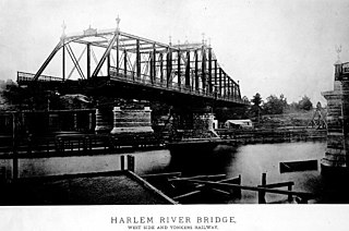
The Putnam Bridge was a swing bridge that spanned the Harlem River and the adjacent tracks of the New York Central Railroad in New York City. The bridge connected Harlem in Manhattan to Concourse, near the current location of Yankee Stadium, in the Bronx. It carried two tracks of the New York and Putnam Railroad, and later the 9th Avenue elevated line of the Interborough Rapid Transit Company (IRT), as well as two pedestrian walkways outside the superstructure.

Manhattan Bridge Loop is a 1928 oil painting by American artist Edward Hopper, depicting the Manhattan Bridge in New York City. It is on display in the Addison Gallery of American Art of the Phillips Academy in Andover, Massachusetts, which received the painting as a gift from art collector Stephen Carlton Clark in 1932.
Florence Howell Barkley (1880–1954) was an American landscape painter and illustrator best known for depictions of seascapes in oil and watercolor and illustrations in many popular newspapers in pen and ink. During this time, she was one of few women who was able to receive formal training in the arts. Although her most well-known work was created in 1912 and exhibited in 1913, her career was disrupted by World War I, and thereafter consisted mostly of freelance illustration work.

Mill Pond Park is a public park in the New York City borough of the Bronx. It was built to compensate for the loss of parkland resulting from the construction of new Yankee Stadium between 2006 and 2009. The park's name was inspired by a dam near the site of a creek that emptied into the Harlem River.


