Aragalur is a village in Salem district, Tamil Nadu, India. It is about 6 km from Thalaivasal and 70 km from Salem.
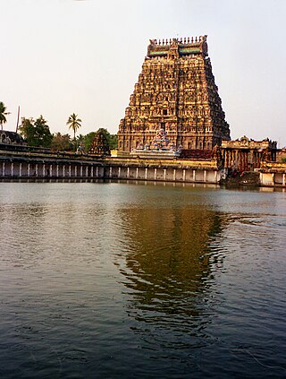
Chidambaram is a town and municipality in Cuddalore district in the Indian state of Tamil Nadu, on the banks of the Vellar River where it meets the Bay of Bengal. It is the headquarters of the Chidambaram taluk. The town is believed to be of significant antiquity and has been ruled, at different times, by the Pallavas until ninth century, Medieval Cholas, Later Cholas, Later Pandyas, Vijayanagara Empire, Thanjavur Nayakas, Marathas and the British. The town is known for the Thillai Nataraja Temple and Thillai Kali Temple, and the annual chariot festival held in the months of December–January and June to July. One of the Divya Desams Divya Sri Govindaraja Perumal Temple (Thiruchitrakoodam) is a part of Thillai Nataraja Temple complex. Thiruvetkalam Shiva Temple, Vadakiruppu, Thirunelvayil Shiva Temple, Sivapuri and Tirukkazhippalai Palvannanathar Temple are the other three ancient Shiva temples in the region.

Tiruvallur is a Grade I municipality in the Indian state of Tamil Nadu. It is located on the banks of Coovum river about 46 km (29 mi) from downtown Chennai (Madras) and just 5 km from megacity border, in the western part of the Chennai Metropolitan Area (CMA). It is a satellite town of Chennai and is the administrative headquarters of Tiruvallur district. The city is known for the Veera Raghavar temple, one of the 108 sacred shrines of Vaishnavites. The tank festival is held at a pond near this temple. A Shiva temple near this shrine which is popular among the locals. There is also a 40-foot (12 m) tall Viswaroopa Panchamukha Hanuman temple, where the murti is made of a single green granite stone.
Nanganallur or Nangainallur is one of the southern neighbourhoods of Chennai, India. Since September 2011, it has become a part of Chennai Corporation. It is a residential area close to the Chennai International Airport.

Batlagundu is a town in Nilakottai block in Dindigul district in the Madurai Region state of Tamil Nadu, India. The name Vetrilaikkundru later transformed and changed to Vathalagundu. The town is the major gateway to Kodaikanal. Subramaniya Siva was a writer, Indian Freedom Fighter, and activist born in Batlagundu. Batlagundu is the fifth-largest town in the Dindigul district. The town is located in such a way connecting three main districts of South Tamil Nadu. Batlagundu has most of the voters in Nilakottai Constituency.
Edappadi is a municipality in the Salem district in the state of Tamil Nadu, India. Edappadi was once known for its thriving power loom industry. The economy is diversified by agriculture, heavy truck transport, granite, entertainment and foundries.
Lalgudi is a town in Tiruchirapalli district in the Indian state of Tamil Nadu. The town of Lalgudi heads the Lalgudi taluk, Lalgudi division, Lalgudi Educational District, Lalgudi DSP and Lalgudi Constituency.
Madhavaram is a neighbourhood of Chennai, Tamil Nadu, India. Located in the northern part of Chennai, it is also a taluk in Chennai District and a zone in Greater Chennai Corporation. It is located in between Perambur and Kodungaiyur. As of 2011, the neighbourhood had a population of 119,105. The Chennai district was expanded on 16 August 2018 by transferring Madhavaram taluk from Tiruvallur district to Chennai district.

Madurantakam is the southernmost suburb of Chennai city and a municipality in Chengalpattu district in the Indian state of Tamil Nadu. The town is known for the artificial and second largest lake in Tamil Nadu, the Maduranthakam lake. It is said to have been built by the Chola King Uttama Chola, also called as Maduranthaka, during his reign. It is also home to the Eri-Katha Ramar Temple. As of 2011, the town had a population of 30,796.
Manamadurai is a Municipality Town in Sivaganga district in the Indian state of Tamil Nadu. Manamadurai falls under Manamadurai Legislative assembly.

Peralasseri is a census town and Panchayat headquarters in Kannur district in the Indian state of Kerala, situated on the Kannur-Kuthuparamba State Highway 38 (Kerala), 12 km from Kannur city, on the bank of Anjarakandy river.

Vadalur is a municipality in Cuddalore district, Tamil Nadu. It is 208 km (129 mi) from Chennai, the state capital of Tamil Nadu.

East Coast Road (ECR), combination of SH-49, NH-332A, NH-32, officially known as Mutthamizh Arignar Kalaignar Road, is a two-lane highway in Tamil Nadu, India, built along the coast of the Bay of Bengal connecting Tamil Nadu's state capital city Chennai with Kanyakumari via Puducherry, Cuddalore, Chidambaram, Sirkali, Thirukkadaiyur, Tharangambadi, Karaikal, Nagore, Nagapattinam, Thiruthuraipoondi, Muthupet, Adirampattinam, Manora, Manamelkudi, Mimisal, Ramanathapuram, Thoothukudi, Tiruchendur, Uvari, Kudankulam. The total length of the road is about 777 km between Chennai and Kanyakumari.
Naduvalur is a village in Gangavalli in the Salem district of the state of Tamil Nadu, located in the north central part of the southernmost state of India.
Poothakkulam, also known as Bhoothakulam, is a village in Kollam district in the state of Kerala, India. The village is located 3.9 km away from Paravur, 11.4 km from Varkala and 23 km from Kollam. In 2011, it had a population of 628,451 residents. The village covers an area of 16.56 km2.
Nallathur is a village in the Cuddalore district of Tamil Nadu, one of 28 states of India. Nallathur's postal code is 605 106.
Periya Kozhappalur is a village in Chetpet Taluk, Tiruvannamalai District, Tamil Nadu, India. Periya Kozhappalur is located 2 kilometres (1.2 mi) east of the state highway SH-4, between Arani and Chetpet, 14 kilometres (8.7 mi) from Arani, 40 kilometres (25 mi) from Vandavasi, and 11 kilometres (6.8 mi) from its taluk main town of Chetpet. Kolappalur is 47 kilometres (29 mi) from its district main city Tiruvannamalai. It is 132 kilometres (82 mi) from its state capital Chennai.
Kaiperambalur is a panchayat village of the Kizhamathdur district in Perambalur, Tamil Nadu, India. It was formally part of the Tiruchirappalli district.
Ramanatham and Tholudur or Thozhudur,, are twin towns by the Vellar River in Cuddalore District, Tamil Nadu, India.

