
Northern Bahr el Ghazal is a state in South Sudan. It has an area of 30,543 km² and is part of the Bahr el Ghazal region. It borders East Darfur in Sudan to the north, Western Bahr el Ghazal to the west and south, and Warrap and the disputed region of Abyei to the east. Aweil is the capital of the state.

The Bahr el Ghazal is a historical region of northwestern South Sudan. Its name came from the river Bahr el Ghazal. The name translates as "sea of gazelles" from Arabic.

Bahr al-Arab (also called the Kiir River) is a river which flows approximately 800 kilometres (500 mi) through the southwest of Sudan and marks part of its international border with South Sudan. It is part of the Nile river system, being a tributary of Bahr el Ghazal, which is a tributary of the White Nile.

The Jur River is a river in western South Sudan, flowing through the Bahr el Ghazal and Equatoria regions. About 485 kilometres (301 mi) long, it flows north and northeast, joining the Bahr el Ghazal River on the western side of the Sudd wetlands. The Jur River is part of the Nile basin, as the Bahr al-Ghazal flows into the White Nile.

Raga is a town in South Sudan and the capital of Lol State.
Marial Bai is a village in Northern Bahr el Ghazal state, South Sudan.
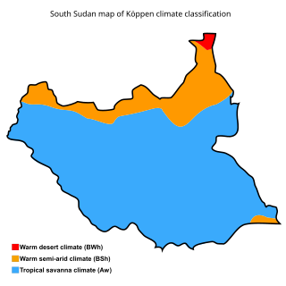
The geography of South Sudan describes the physical features of South Sudan, a country in East Africa. South Sudan is a landlocked country and borders – clockwise – Sudan from the north, Ethiopia from the east, Kenya, Uganda and the Democratic Republic of the Congo from the south and the Central African Republic from the west.

The Kuru River, or Chel River is a stream in the South Sudanese states of Western Bahr el Ghazal and Northern Bahr el Ghazal. It is a headwater of the Lol River.
The Pongo River is a stream in the South Sudanese state of Northern Bahr el Ghazal. It is a right tributary of the Lol River.
The Lol River, or Loll River, is a stream in northern South Sudan that feeds the Bahr al-Arab, known locally as the Kiir River.
The Sopo River is a river in South Sudan's state of Western Bahr el Ghazal.

Aweil State was a state in South Sudan that existed between 2 October 2015 and 22 February 2020. It was located in the Bahr el Ghazal region and it borders Gogrial to the east, Lol to the west, Aweil East to the north, and Wau to the south. Its capital and largest city was Aweil.

Aweil East also known as Abiem, was a state in South Sudan that existed between 2 October 2015 and 22 February 2020.It had an estimated population of 571,728 people and an area of 6,172.23 KM square. It was located in northern-western South Sudan. Its capital and largest city was Malualkon. The state is located in the Bahr el Ghazal region and it bordered Twic State and Gogrial State to the east, Aweil State to the south, Lol State to the west, the disputed Abyei State region to the northeast, and Sudan to the north.
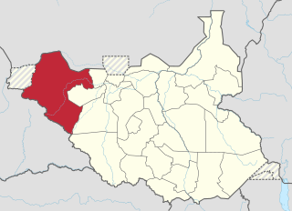
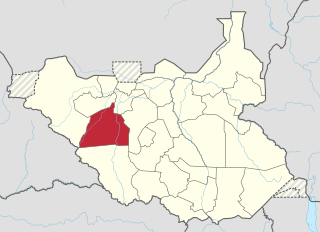
Lol was a state in South Sudan that existed between 2 October 2015 and 22 February 2020. It was located in the Bahr el Ghazal region, which is in the northwest section of the country. Lol state bordered Haut-Mbomou and Haute-Kotto in the Central African Republic to the west, South Darfur and East Darfur in Sudan to the north, the disputed region of Kafia Kingi to the northwest, Aweil East State to the northeast, Aweil State to the east, Gbudwe State to the south, and Wau State to the southeast. The state was created alongside 27 other states after a decree issuing the creation of 28 states took place. It was dissolved at the conclusion of the South Sudanese Civil War.
Wau State was a state in South Sudan that existed between 2 October 2015 and 22 February 2020. It was located in the Bahr el Ghazal region, and was part of the former state of Western Bahr el Ghazal. Wau State bordered Aweil State, Gbudwe State, Gogrial State, Lol State, and Tonj State.
Raja County is an administrative area in Lol State, South Sudan.
The Tonj River, also called the Ibba River or Nyatt Ayok, is a river of South Sudan. It is a left tributary of the Bahr el Ghazal River.
Liffi was a military station in Sudan, named after a nearby hill, and the surrounding region. It was the location of several clashes between Egyptian forces and Mahdists in the early 1880s. In 1894 the Belgians temporarily established a base there.
The Boro River is a river of South Sudan, a headwater of the Magadhik River, which in turn is a headwater of the Lol River.
The Biri River is a river of South Sudan. It is a left tributary of the Kuru River, a headwater of the Lol River.
