Magere Brug

Last updated
Magere Brug
Amsterdam Magere Brug 3.jpg
The Magere Brug in 2017
Coordinates 52°21′49″N4°54′09″E / 52.36361°N 4.90250°E / 52.36361; 4.90250
CarriesN+A
Crosses Amstel
Locale Amsterdam, Netherlands
Location
Magere Brug

The Magere Brug (English: Skinny Bridge) is a bridge over the river Amstel in Amsterdam, Netherlands. It connects the banks of the river at Kerkstraat, between the Keizersgracht and Prinsengracht. [1]

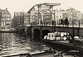
The central section of the Magere Brug is a bascule bridge made of white-painted wood. The present bridge was built in 1934. The first bridge at this site was built in 1691 as Kerkstraatbrug and had 13 arches. Because this bridge was very narrow, the locals called it magere brug, which literally means "skinny bridge". In 1871 the state of the bridge had deteriorated so much, it was demolished and replaced by a nine-arched wooden bridge. Half a century later, this bridge also needed to be replaced. Architect Piet Kramer made several designs for a steel and stone bridge, but the city decided to replace it with a new bridge that looked the same as the previous, only slightly bigger. In 1934, that bridge was demolished, and replaced by a redesign made by Piet Kramer. The last major renovation was in 1969. Until 1994, the bridge was opened by hand, but is now operated automatically.

Use of the bridge has been limited to pedestrians and cyclists since 2003. The centre-part is opened many times, daily, in order to let river traffic pass. The sightseeing tour boats are low enough to pass underneath the bridge when closed. The bridge is decorated with 1,200 light bulbs which are turned on in the evening.

A story told to tourists about the origins of the 1691 version of the bridge is that it was built by two sisters who lived on opposite sides of the Amstel river and wanted to be able to visit one another, every day. In one variant of the story, the sisters were not able to afford a bridge of adequate width or height for general use, so a very narrow bridge was built, hence its name. In another variant, the sisters' last name was Mager (skinny), which gave name to the bridge (rather than its narrowness). [1] Recent research of city archives revealed the name has its origin in the fact that originally a broad and monumental stone bridge was planned during Amsterdam's prosperous Golden Age, but the 1672 economic setback forced the city council to drastically scale back the plans, and build a basic and simple structure instead. [2]

Locals regard the bridge as the most romantic of all in Amsterdam. It is a common site for proposals and lovers' strolls. Additionally, legend says that a kiss between lovers while on this bridge (or passing beneath by boat) ensures that they will be in love forever.

The bridge can be seen in a number of films, including the 1971 James Bond film Diamonds Are Forever , in which the legend of the bridge's being built is told by a boat tour guide.

Related Research Articles

<span class="mw-page-title-main">Amstelveen</span> Municipality in North Holland, Netherlands

Amstelveen is a municipality in the province of North Holland, Netherlands, with a population of 92,353 as of 2022. It is a suburban part of the Amsterdam metropolitan area.

<span class="mw-page-title-main">Amstel</span> River in Noord-Holland, Netherlands

The Amstel is a river in the province of North Holland in the Netherlands. It flows from the Aarkanaal and Drecht in Nieuwveen northwards, passing Uithoorn, Amstelveen, and Ouderkerk aan de Amstel, to the IJ in Amsterdam, to which the river gives its name. Annually, the river is the location of the Liberation Day concert, Head of the River Amstel rowing match, and the Amsterdam Gay Pride boat parade.

<span class="mw-page-title-main">Singel</span> Street and canal in Amsterdam

The Singel is one of the canals of Amsterdam. The Singel encircled Amsterdam in the Middle Ages, serving as a moat around the city until 1585, when Amsterdam expanded beyond the Singel. The canal runs from the IJ bay, near the Central Station, to the Muntplein square, where it meets the Amstel river. It is now the inner-most canal in Amsterdam's semicircular ring of canals.

<span class="mw-page-title-main">Blauwbrug</span> Historic bridge in Amsterdam

The Blauwbrug is a historic bridge in Amsterdam, Netherlands over the river Amstel. It connects the Rembrandtplein area with the Waterlooplein area, and lies south to the Stopera.

<span class="mw-page-title-main">Canals of Amsterdam</span> Grachten dug in the 17th century during the Dutch Golden Age; UNESCO World Heritage Site

Amsterdam, capital of the Netherlands, has more than 100 kilometers (62 mi) of grachten (canals), about 90 islands and 1,500 bridges. The three main canals, dug in the 17th century during the Dutch Golden Age, form concentric belts around the city, known as the Grachtengordel. Alongside the main canals are 1550 monumental buildings. The 17th-century canal ring area, including the Prinsengracht, Keizersgracht, Herengracht and Jordaan, were listed as UNESCO World Heritage Site in 2010, contributing to Amsterdam's fame as the "Venice of the North".

<span class="mw-page-title-main">Amstelland</span>

Amstelland is the area along the river Amstel in the Netherlands, beginning in South Holland and running north towards Amsterdam in southern North Holland.

<span class="mw-page-title-main">Ferdinand Bolstraat</span>

The Ferdinand Bolstraat is a street in Amsterdam, named after the artist Ferdinand Bol in 1872.

<span class="mw-page-title-main">Rivierenbuurt (Amsterdam)</span> Neighbourhood of Amsterdam in North Holland, Netherlands

Rivierenbuurt is a neighbourhood of Amsterdam, Netherlands. The neighbourhood is situated in the eastern part of the borough of Amsterdam-Zuid, bordered by the river Amstel to the east, the Boerenwetering canal in the west, the Amstelkanaal in the north and the A10 motorway in the south. In 2013, the Rivierenbuurt had approximately 28,400 residents.

<span class="mw-page-title-main">Schinkelbuurt</span> Neighborhood of Amsterdam in North Holland, Netherlands

Schinkelbuurt is a little neighborhood of Amsterdam, Netherlands. It is located directly south of Amsterdam's city centre and it is part of the borough Amsterdam-Zuid, in the part of the city known as the Old South.

<span class="mw-page-title-main">Plan Zuid</span>

The Plan Zuid is an urban development plan of Amsterdam South in the city of Amsterdam, Netherlands, designed by architect Hendrik Petrus Berlage. Berlage was responsible for the urban concept (1915) and the architects of the Amsterdam School designed the implementation of the plan.

<span class="mw-page-title-main">Korenbeurs (Amsterdam)</span>

The Korenbeurs was a 17th-century commodity market in Amsterdam where grain was traded. The building stood on the banks of the Amstel, on the western side (Nieuwezijde) of the Damrak. It was directly south of the Oude Brug bridge, on a spot now occupied by the former stock and commodity exchange Beurs van Berlage.

<span class="mw-page-title-main">Lijnbaansgracht</span>

Lijnbaansgracht is a partly filled-in canal in Amsterdam which bends beyond the boundary of the center, Amsterdam-Centrum. The canal runs parallel to the Singelgracht, between the Brouwersgracht and the Reguliersgracht.

<span class="mw-page-title-main">Shaw's Bridge</span>

Shaw's Bridge is the name given to two adjacent bridges across the River Lagan in Belfast, Northern Ireland. The older of the bridges is a historic stone arched bridge, which is open to cyclists and pedestrians. The new bridge is a concrete bridge which carries the A55 road.

<span class="mw-page-title-main">Nieuwe Herengracht</span> Canal in Amsterdam

The Nieuwe Herengracht is a canal in Centrum district of Amsterdam. The canal is an extension of the Herengracht that runs between the Amstel and the Scharrebiersluis (lock) leading to the Schippersgracht from the Entrepotdok. It is in the Plantage neighborhood in the eastern part of the Grachtengordel.

<span class="mw-page-title-main">Grimburgwal</span> Canal in Amsterdam

The Grimburgwal is a small canal and street in the center of Amsterdam.

<span class="mw-page-title-main">Oudezijds Kolk</span> Canal in Amsterdam

The Oudezijds Kolk is a short and narrow canal/lock in Amsterdam between the Oudezijds Voorburgwal and the Oosterdok.

<span class="mw-page-title-main">Entrepotdoksluis</span> Bridge in Amsterdam

The Entrepotdoksluis is a bridge in Amsterdam-Centrum that crosses a lock by the same name.

<span class="mw-page-title-main">Prins Hendrikkade</span> Street in Amsterdam

Prins Hendrikkade is a major street in the centre of Amsterdam. It passes Amsterdam Central Station, intersects the Damrak at the mouth of the Amstel river, and forms the southern end of the IJtunnel across the IJ bay. The street formed the northern edge and outer harbour of the city until the 19th century. It was named after Prince Henry of the Netherlands, youngest son of King William II, following Henry's death in 1879.

<span class="mw-page-title-main">Berlagebrug</span> Bridge in Amsterdam

The Berlagebrug is a bascule bridge over the river Amstel in Amsterdam, Netherlands. The bridge was commissioned by the municipality and named after its main architect Hendrikus Petrus Berlage (1856–1934). It was constructed from 1926 to 1931 and officially opened on 28 May 1932. It has been designated as a Rijksmonument since 11 May 2008.

References

  1. 1 2 "Magere Brug (Skinny Bridge)". www.iamsterdam.com.
  2. Abrahamse, Jaap Evert (2011). De Grote Uitleg van Amsterdam (in Dutch) (2nd print ed.). Uitgeverij Thoth. ISBN   978-90-6868-491-9