Related Research Articles

Queenstown is a resort town in Otago in the south-west of New Zealand's South Island. It has an urban population of 29,000.

The Pink and White Terraces, were natural wonders of New Zealand. They were reportedly the largest silica sinter deposits on Earth. Until recently, they were lost and thought destroyed in the 1886 eruption of Mount Tarawera, while new hydrothermal features formed to the south-west i.e. Waimangu Volcanic Rift Valley.

Rotorua is a city in the Bay of Plenty Region of New Zealand's North Island. The city lies on the southern shores of Lake Rotorua, from which it takes its name. It is the seat of the Rotorua Lakes District, a territorial authority encompassing Rotorua and several other nearby towns. Rotorua has an estimated resident population of 58,900, making it the country's 12th largest urban area, and the Bay of Plenty's second-largest urban area behind Tauranga.

Fiordland is a geographical region of New Zealand in the south-western corner of the South Island, comprising the westernmost third of Southland. Most of Fiordland is dominated by the steep sides of the snow-capped Southern Alps, deep lakes, and its steep, glacier-carved and now ocean-flooded western valleys. The name "Fiordland" comes from a variant spelling of the Scandinavian word for this type of steep valley, "fjord". The area of Fiordland is dominated by, and very roughly coterminous with, Fiordland National Park, New Zealand's largest National Park.

Lake Wānaka is New Zealand's fourth-largest lake and the seat of the town of Wānaka in the Otago region. The lake is 278 meters above sea level, covers 192 km2 (74 sq mi), and is more than 300 m (980 ft) deep.
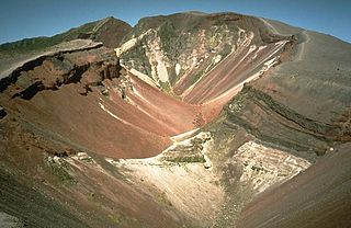
Mount Tarawera is a volcano on the North Island of New Zealand within the older but volcanically productive Ōkataina Caldera. Located 24 kilometres southeast of Rotorua, it consists of a series of rhyolitic lava domes that were fissured down the middle by an explosive basaltic eruption in 1886. While the 1886 eruption was basaltic, study has shown there was only a small basalt component to the previous recent rhyolitic predominant eruptions. This eruption was one of New Zealand's largest historical eruptions, and killed an estimated 120 people. The fissures run for about 17 kilometres (11 mi) northeast–southwest.

Te Anau is a town in the Southland region of the South Island of New Zealand. In Māori, Te-Anau means the Place of the Swirling Waters. It is on the eastern shore of Lake Te Anau in Fiordland. Te Anau is 155 kilometres north of Invercargill and 171 kilometres to the southwest of Queenstown. Manapouri lies 21 kilometres to the south. Te Anau lies at the southern end of the Milford Road, 117 kilometres to the south of Milford Sound.

Te Wairoa was a village close to the shore of Lake Tarawera near Rotorua, New Zealand. The village was buried by volcanic ash in the 1886 eruption of Mount Tarawera. It was later excavated and is now open as a tourist destination, the Buried Village. The nearby Wairere Falls are also a tourist destination.
Lake Ōkāreka is one of four small lakes lying between Lake Rotorua and Lake Tarawera, in the Bay of Plenty Region of New Zealand's North Island. The others are Lake Rotokakahi, Lake Tikitapu, and Lake Ōkataina. All lie within the Ōkataina Caldera, along its western edge.

Lake Rotomahana is an 890-hectare (2,200-acre) lake in northern New Zealand, located 20 kilometres to the south-east of Rotorua. It is immediately south-west of the dormant volcano Mount Tarawera, and its geography was substantially altered by a major 1886 eruption of Mount Tarawera. Along with the mountain, it lies within the Ōkataina Caldera. It is the most recently formed larger natural lake in New Zealand, and the deepest in the Rotorua district.
Tūhourangi is a Māori iwi of New Zealand with a rohe centered on Lake Tarawera, Lake Rotomahana, Lake Okaro, Lake Okareka, Lake Rotokākahi, Lake Tikitapu and Lake Rotorua.

Frederick Augustus Bennett was a New Zealand Anglican Suffragan Bishop who served as the first Bishop of Aotearoa from 1928 to 1950.

Alfred Patchett Warbrick was a New Zealand boatbuilder, rugby player and tourist guide.

Te Keepa Te Rangi-pūawhe was a New Zealand Māori tribal leader of the Tūhourangi iwi, and a major in the New Zealand militia.

Mita Taupopoki was a notable Māori tribal leader of New Zealand. He identified with Ngāti Wāhiao, a hapū (subtribe) of the Tūhourangi iwi of Te Arawa.

Southland is New Zealand's southernmost region. It consists mainly of the southwestern portion of the South Island and Stewart Island/Rakiura. It includes Southland District, Gore District and the city of Invercargill. Murihiku Southland is bordered by the culturally similar Otago to the north and east, and the West Coast in the extreme northwest. The region covers over 3.1 million hectares and spans 3,613 km of coast. As of June 2023, Southland has a population of 103,900, making it the eleventh-most-populous New Zealand region, and the second-most sparsely populated.
The Reverend Seymour Mills Spencer was born in Hartford, Connecticut. He and his wife Ellen Stanley Spencer followed an ambition to carry out the role of missionary work in New Zealand. He trained for missionary work in England at the Church Missionary Society College, Islington. The Church Missionary Society (CMS) was an evangelical organisation that was part of the Church of England.

The 1886 eruption of Mount Tarawera was a violent volcanic eruption that occurred in the early hours of 10 June 1886 at Mount Tarawera, near Rotorua on New Zealand's North Island. The eruption reached an estimated volcanic explosivity index (VEI) of 5 and killed an estimated 120 people, making it the largest and deadliest in New Zealand during the past 500 years, a period that includes the entirety of European history in New Zealand.
Witarina Te Miriarangi Parewahaika Harris was a New Zealand film actress, Māori language advocate, entertainer and public servant. She featured in the 1929 Universal Pictures silent film Under the Southern Cross as the heroine Princess Miro in her only film credit.

Lake Rotomakariri was a lake which formerly existed in the basin that is now occupied by Lake Rotomahana, in the Bay of Plenty region of New Zealand's North Island. The lake's name was in contrast to the nearby Lake Rotomahana, which prior to the 1886 eruption of Mount Tarawera, was a shallower warm water lake. Prior to this eruption, Lake Rotomakariri sat in a shallow basin surrounded by marshes, draining into Lake Tarawera by Awapurohe Creek and Rotomahana's outflow of Kaiwaka Stream. The eruption of Mount Tarawera initially destroyed Lake Rotomakariri and its lakeside village with the loss of 19 lives, though water entering the new crater gradually refilled Lake Rotomakariri after volcanic activity subsided. As water accumulated over the decade after the eruption, Lake Rotomakariri was absorbed by the larger Lake Rotomahana, which eventually rose to about 36–48 m (118–157 ft) above its pre-eruption level due to the previous outflow of the basin being blocked by ashfall.
References
- 1 2 3 "Magic Playgrounds in New Zealand's Geyserland". Ngā Taonga Sound & Vision. 1935. Retrieved 13 January 2023.
- ↑ "Entertainments". Papers Past . No. 25283. Southland Times. 13 May 1935. p. 12. Retrieved 13 January 2023.
| | This article about a documentary film is a stub. You can help Wikipedia by expanding it. |
| | This article related to a New Zealand film is a stub. You can help Wikipedia by expanding it. |