Lake Rotoiti (Bay of Plenty)

Last updated
Lake Rotoiti
Jetty on Lake Rotoiti.jpg
Lake Rotoiti
NZ-NI plain map.png
Disc Plain red.svg
Lake Rotoiti
Rotoiti Bathymetry.png
Bathymetric map of Lake Rotoiti [1]
Location Rotorua Lakes, Bay of Plenty Region, North Island
Coordinates 38°02′20″S176°25′40″E / 38.0390°S 176.4277°E / -38.0390; 176.4277
Type crater lake
Primary outflows Kaituna River
Basin  countriesNew Zealand
Max. length15 km (9.3 mi) [2]
Max. width3.6 km (2.2 mi) [2]
Surface area34.3 km2 (13.2 sq mi) [2]
Average depth33 m (108 ft) [2]
Max. depth100.0 m (328.1 ft) [2]
Surface elevation279 m (915 ft) [2]
References [2]

Lake Rotoiti is a lake in the Bay of Plenty region of New Zealand. [3] It is the northwesternmost in a chain of lakes formed within the Okataina Caldera. The lake is close to the northern shore of its more famous neighbour, Lake Rotorua, and is connected to it via the Ohau Channel. It drains to the Kaituna River, which flows into the Bay of Plenty near Maketu.

Contents

The full name of the lake is Te Rotoiti-kite-a-Īhenga, [4] which in the Māori language means "The Small Lake Discovered By Īhenga", the Māori explorer also credited with discovering Lake Rotorua. Legend says that the lake was named as such because when Ihenga first saw it, he was only able to see a small part of it and thought the lake was a lot smaller.

Since the 1960s, the quality of lake water has been negatively affected by inflows of nitrogen rich water from Lake Rotorua, agricultural run-off from surrounding farms and seepage from domestic septic tanks. [5] The effects of this included an almost permanent algal bloom in the Okere arm of the lake and choking lake weed growth in other still areas of the lake. A barrier to divert the nutrient rich waters of Lake Rotorua into the Kaituna River was completed in late 2008.

The Bay of Plenty Regional Council expected to see improvement in lake water quality within five years [6] and the Rotorua Te Arawa Lakes Program reported in 2013 that the intervention has significantly improved water quality. Water quality is the highest it has been in decades, on track to meet targets set by the Program to meet community expectations. [7]

Lake Rotoiti has thermal hot-spring baths on the southern shore which are accessible by boat. [8]

Lake Rotoiti NZ7 3514 - 32143651807.jpg
Panorama of Lake Rotoiti
Lake Rotoiti NZ7 3525 - 47085364681.jpg
Homes and vacation homes nestled in around Lake Rotoiti

Geology

Its joint drainage with Lake Rotorua through the Ohau Channel depends upon the sinking Tikitere graben which is also very geothermally active on the south eastern margins of the lake. There appear to have been Rotoiti eruptive vents at the eastern end of the lake and although these are part of the Ōkataina Volcanic Centre they are believed to be in an area of collapse subsidence outside the north western margins of the Ōkataina Caldera itself. [9] [lower-alpha 1]

This region of the caldera was at one time termed the Haroharo Caldera, but has been renamed in the more standard major event fashion to the Rotoiti Caldera. As postulated, this caldera does not house the lake. [9] The age of this large eruption of more than 100 cubic kilometres (24 cu mi) of magma [11] was historically ill-defined due to several complexities and the literature gives a range from 40,000 years to 64,000 years ago with 47,400 ± 1500 years ago being recently quoted. [12] [13] What is not now challenged is that this was a paired eruption with a nearby vent in the Ōkataina Caldera that had a separate magma source and erupted Earthquake Flat breccia. [14] [11]

Notes

  1. Technically significant surface vents can be well separated from a magma chamber and its associated area of caldera collapse immediately above. A recent extreme example with a basalt eruption was in Iceland where the significant vent was over 40 km (25 mi) from the caldera collapse that drove the eruption. [10]

Related Research Articles

<span class="mw-page-title-main">Taupō Volcanic Zone</span> Active volcanic zone in New Zealand

The Taupō Volcanic Zone (TVZ) is a volcanic area in the North Island of New Zealand that has been active for at least the past two million years and is still highly active. Mount Ruapehu marks its south-western end and the zone runs north-eastward through the Taupō and Rotorua areas and offshore into the Bay of Plenty. It is part of the larger Central Volcanic Region that extends further westward through the western Bay of Plenty to the eastern side of the Coromandel Peninsula and has been active for four million years. At Taupō the rift volcanic zone is widening east–west at the rate of about 8 mm per year while at Mount Ruapehu it is only 2–4 mm per year but this increases at the north eastern end at the Bay of Plenty coast to 10–15 mm per year. It is named after Lake Taupō, the flooded caldera of the largest volcano in the zone, the Taupō Volcano and contains a large central volcanic plateau as well as other landforms associated with its containing tectonic intra-arc continental Taupō Rift.

<span class="mw-page-title-main">Mount Tarawera</span> Volcano in New Zealand

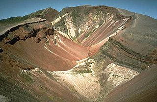
Mount Tarawera is a volcano on the North Island of New Zealand within the older but volcanically productive Ōkataina Caldera. Located 24 kilometres southeast of Rotorua, it consists of a series of rhyolitic lava domes that were fissured down the middle by an explosive basaltic eruption in 1886. While the 1886 eruption was basaltic, study has shown there was only a small basalt component to the previous recent rhyolitic predominant eruptions. This eruption was one of New Zealand's largest historical eruptions, and killed an estimated 120 people. The fissures run for about 17 kilometres (11 mi) northeast–southwest.

<span class="mw-page-title-main">Rotorua Caldera</span> Volcanic caldera in New Zealand

The Rotorua Caldera is a large rhyolitic caldera that is filled by Lake Rotorua. It was formed by an eruption 240,000 years ago that produced extensive pyroclastic deposits. Smaller eruptions have occurred in the caldera since, the most recent less than 25,000 years ago. It is one of several large volcanoes in the Taupō Volcanic Zone on the North Island of New Zealand.

<span class="mw-page-title-main">Lake Ōkataina</span> Volcanic crater lake in New Zealand

Lake Ōkataina is the northernmost and largest of four smaller lakes lying between Lake Rotorua and Lake Tarawera in the Bay of Plenty Region of New Zealand's North Island. The others are Lake Rotokakahi, Lake Tikitapu, and Lake Ōkareka. All lie within the Ōkataina caldera, along its western edge.

<span class="mw-page-title-main">Lake Rotorua</span> Lake in the North Island of New Zealand

Lake Rotorua is the second largest lake in the North Island of New Zealand by surface area, and covers 79.8 km2. With a mean depth of only 10 metres it is considerably smaller than nearby Lake Tarawera in terms of volume of water. It is located within the Rotorua Caldera in the Bay of Plenty Region.

<span class="mw-page-title-main">Oruanui eruption</span> Worlds most recent supereruption, of Taupō Volcano, New Zealand

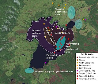
The Oruanui eruption of New Zealand's Taupō Volcano was the world's most recent supereruption, and largest phreatomagmatic eruption characterised to date.

The region around the city of Rotorua, in New Zealand's North Island, contains several lakes which have a total area of about 250 square kilometres. The term Rotorua lakes is ambiguous as it has been used historically for a New Zealand administrative area. From biggest to smallest, these are Lake Rotorua, Lake Tarawera, Lake Rotoiti, Lake Rotomā, Lake Okataina, Lake Rotoehu, Lake Rotomahana, Lake Rerewhakaaitu, Lake Rotokākahi, Lake Okareka and Lake Tikitapu. There are also smaller lakes including: Lake Okaro, Lake Rotokawa, Lake Rotokawau and Lake Rotongata. Most of the lakes have formed due to volcanic activity and some have current geothermal activity. The region is part of the Taupō Volcanic Zone, the world's most active area of explosive silicic volcanic activity in geologically recent time.

<span class="mw-page-title-main">1886 eruption of Mount Tarawera</span> Volcanic eruption in New Zealand

The 1886 eruption of Mount Tarawera was a violent volcanic eruption that occurred in the early hours of 10 June 1886 at Mount Tarawera, near Rotorua on New Zealand's North Island. The eruption reached an estimated volcanic explosivity index (VEI) of 5 and killed an estimated 120 people, making it the largest and deadliest in New Zealand during the past 500 years, a period that includes the entirety of European history in New Zealand.

The Haroharo Caldera is a 26 by 16 km postulated volcanic feature in Taupō Volcanic Zone of the North Island, New Zealand within the larger and older Ōkataina Caldera. Since 2010 further studies have tended to use the terms Haroharo vent alignment, Utu Caldera, Matahina Caldera, Rotoiti Caldera and a postulated Kawerau Caldera to the features assigned to it. However the name is used in the peer reviewed literature to summarise and group these features based on gravitational and magnetic features.

<span class="mw-page-title-main">Kapenga Caldera</span> Volcanic caldera in New Zealand

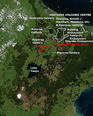
The Kapenga Caldera in New Zealand’s Taupō Volcanic Zone lies in a low land area immediately south of Lake Rotorua through the Hemo Gap in the Rotorua Caldera rim. At some time more than 60,000 years ago Lake Rotorua drained through the Hemo Gap and some of the Kapenga Caldera floor was likely occupied by a lake, that has been called Kapenga.

<span class="mw-page-title-main">Ōkataina Caldera</span> Volcanic caldera in New Zealand

Ōkataina Caldera is a volcanic caldera and its associated volcanoes located in Taupō Volcanic Zone of New Zealand's North Island. It has several actual or postulated sub calderas. The Ōkataina Caldera is just east of the smaller separate Rotorua Caldera and southwest of the much smaller Rotomā Embayment which is usually regarded as an associated volcano. It shows high rates of explosive rhyolitic volcanism although its last eruption was basaltic. The postulated Haroharo Caldera contained within it has sometimes been described in almost interchangeable terms with the Ōkataina Caldera or volcanic complex or centre and by other authors as a separate complex defined by gravitational and magnetic features.. Since 2010 other terms such as the Haroharo vent alignment, Utu Caldera, Matahina Caldera, Rotoiti Caldera and a postulated Kawerau Caldera are often used, rather than a Haroharo Caldera classification.

<span class="mw-page-title-main">Rotomā Caldera</span> Volcanic caldera in the North Island of New Zealand

The relatively small Rotomā Caldera is in the Taupō Volcanic Zone in the North Island of New Zealand.

<span class="mw-page-title-main">Paeroa Fault</span> Active fault in New Zealand

The Paeroa Fault is a seismically active area in the Taupō District, Waikato Region of the central North Island of New Zealand.

<span class="mw-page-title-main">Ohakuri Caldera</span> Volcanic caldera in New Zealand

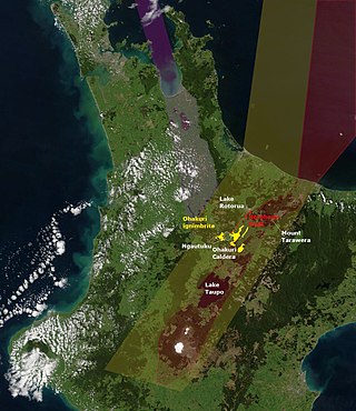
The Ohakuri Caldera was formed in a paired single event eruption of Ohakuri ignimbrite and is located in the Taupō Volcanic Zone on the North Island of New Zealand. Its significance was first recognised in 2004, as the geology of the area had been misunderstood until then. The paired eruption resulted in a very large eruption sequence in the Taupō Volcanic Zone about 240,000 years ago that included the formation of Lake Rotorua and eruption of the Mamaku ignimbrite.

<span class="mw-page-title-main">Ōkāreka Embayment</span> Volcano in North Island, New Zealand

The Ōkāreka Embayment is a volcanic feature in Taupo Volcanic Zone of New Zealand. It most significant recent volcanic eruption was about 15,700 years ago and this deposited the widespread Rotorua tephra that reached beyond Auckland.

The Taupō Fault Belt contains many almost parallel active faults, and is located in the Taupō Rift of the central North Island of New Zealand geographically between Lake Taupō and the lakes of Rotorua, Tarawera, Rotomahana and Rerewhakaaitu. The potential active fault density is very high, with only 0.1 to 1 km separating the north-east to south-west orientated normal fault strands on detailed mapping of part of the belt. The Waikato River bisects the western region of the belt.

<span class="mw-page-title-main">Tikitere Graben</span> A geological feature in the North Island of New Zealand

The Tikitere Graben is a intra-rift graben in the North Island of New Zealand that contains the Ohau Channel, which drains Lake Rotorua into Lake Rotoiti with a minimal drop between the lakes.

The Manawahe Fault line is a seismically active area in the Bay of Plenty Region of the central North Island of New Zealand with the potential to be involved with other faults in an Mw7.0 event.

<span class="mw-page-title-main">Puhipuhi Embayment</span> Volcanic area in North Island, New Zealand

The Puhipuhi Embayment is a volcanic feature in Taupo Volcanic Zone of New Zealand associated with the collapse of the Ōkataina Caldera wall to its west. Its latest significant volcanic eruption was about 31,500 years ago and this dating required a reassessment of recent activity at the Eastern extension of the Tarawera vent alignment.

The Rotoiti Caldera is a postulated, mainly infilled sub caldera of the Ōkataina Caldera based upon gravitational and magnetic evidence. While bathymetry of Lake Rotoiti is consistent with volcanic vents being present, they could be in an area of collapse subsidence outside the north western margins of the Rotoiti Caldera itself.

References

  1. de Ronde, Cornel E.J.; Caratori Tontini, Fabio; Black, Jenny (2021). "Bathymetric map of Lake Rotoiti, New Zealand". GNS Science Rotorua Lakes map series. doi:10.21420/8123-EA25 . Retrieved 31 August 2023.
  2. 1 2 3 4 5 6 7 Lowe, D.J.; Green, J.D. (1987). Viner, A.B. (ed.). Inland waters of New Zealand. Wellington: DSIR Science Information Publishing Centre. pp. 471–474. ISBN   0-477-06799-9.
  3. "Place name detail: Lake Rotoiti". New Zealand Gazetteer. New Zealand Geographic Board . Retrieved 2009-03-18.
  4. McKinnon, Malcolm (2 March 2009). "Volcanic Plateau places - Lake Rotoiti to Lake Rotomā". Te Ara New Zealand. Retrieved 19 September 2012.
  5. "Ohau Channel Diversion Wall Monitoring". June 2011. Archived from the original on 2013-02-12. Retrieved 2013-01-03.
  6. "Ohau Channel Diversion Wall". Archived from the original on 2015-11-24. Retrieved 2013-01-03.
  7. "Rotorua Te Arawa Lakes Program, Lake Rotoiti Water Quality Status" . Retrieved 2015-04-30.
  8. "Lake Rotoiti, Lake Rotoehu and Lake Rotoma". Archived from the original on 2012-11-15. Retrieved 2013-01-03.
  9. 1 2 Hughes, Ery C.; Law, Sally; Kilgour, Geoff; Blundy, Jon D.; Mader, Heidy M. (2023). "Storage, evolution, and mixing in basaltic eruptions from around the Okataina Volcanic Centre, Taupō Volcanic Zone, Aotearoa New Zealand". Journal of Volcanology and Geothermal Research. 434 (107715): 107715. doi:10.1016/j.jvolgeores.2022.107715. hdl: 20.500.11820/9f5c151c-1f2e-47ed-a264-7649eacdf669 . ISSN   0377-0273. S2CID   253783414.
  10. Riel, B.; Milillo, P.; Simons, M.; Lundgren, P.; Kanamori, H.; Samsonov, S. (2015). "The collapse of Bárðarbunga caldera, Iceland". Geophysical Journal International. 202 (1): 446–453. doi: 10.1093/gji/ggv157 .
  11. 1 2 Shane, Phil; Nairn, I.A.; Smith, Victoria C. (2005). "Magma mingling in the ~50 ka Rotoiti eruption from Okataina Volcanic Centre: Implications for geochemical diversity and chronology of large volume rhyolites". Journal of Volcanology and Geothermal Research. 139 (3–4): 295–313. Bibcode:2005JVGR..139..295S. doi:10.1016/j.jvolgeores.2004.08.012.
  12. Flude, S.; Storey, M. (2016). "40Ar/39Ar age of the Rotoiti Breccia and Rotoehu Ash, Okataina Volcanic Complex, New Zealand, and identification of heterogeneously distributed excess 40Ar in supercooled crystals" (PDF). Quaternary Geochronology. 33: 13–23. doi:10.1016/j.quageo.2016.01.002.
  13. Schmitz, Mark D.; Smith, Ian E. M. (2004). "The Petrology of the Rotoiti Eruption Sequence, Taupo Volcanic Zone: an Example of Fractionation and Mixing in a Rhyolitic System". Journal of Petrology. 45 (10): 2045–2066. doi:10.1093/petrology/egh047.
  14. Houghton B F, Wilson C J N, McWilliams M O, Lanphere M A, Weaver S D, Briggs R M, Pringle M S, 1995. Chronology and dynamics of a large silicic magmatic system: Central Taupo Volcano Zone, New Zealand. Geology, 23: 13-16.