Rotorua is a city in the Bay of Plenty Region of New Zealand's North Island. It is sited on the southern shores of Lake Rotorua, from which it takes its name. It is the seat of the Rotorua Lakes District, a territorial authority encompassing Rotorua and several other nearby towns. It has an estimated resident population of 58,900, making it the country's 13th largest urban area, and the Bay of Plenty's second-largest urban area behind Tauranga.
Te Puke is a town located 18 kilometres southeast of Tauranga in the Western Bay of Plenty of New Zealand. It is particularly well known for the cultivation of Kiwifruit.
Ngongotahā is a small settlement on the western shores of Lake Rotorua in the North Island of New Zealand. It is located 10 km (6.2 mi) northwest of the Rotorua central business district, and is considered as a suburb of Rotorua. It is part of the Rotorua functional urban area as defined by Statistics New Zealand. Ngongotahā has a population of 5,230 as of June 2023.

Tolaga Bay is both a bay and small town on the East Coast of New Zealand's North Island located 45 kilometres northeast of Gisborne and 30 kilometres south of Tokomaru Bay.
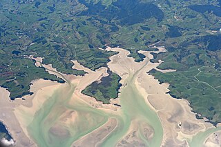
Kawhia Harbour is one of three large natural inlets in the Tasman Sea coast of the Waikato region of New Zealand's North Island. It is located to the south of Raglan Harbour, Ruapuke and Aotea Harbour, 40 kilometres southwest of Hamilton. Kawhia is part of the Ōtorohanga District and is in the King Country. It has a high-tide area of 68 km2 (26 sq mi) and a low-tide area of 18 km2 (6.9 sq mi). Te Motu Island is located in the harbour.

Ngāi Te Rangi or Ngāiterangi is a Māori iwi, based in Tauranga, New Zealand. Its rohe extends to Mayor Island / Tuhua and Bowentown in the north, to the Kaimai Range in the west, south of Te Puke and to Maketu in the east.
Hunterville is a small town in the Rangitikei district of the North Island of New Zealand. It is located halfway between Taupo and Wellington on State Highway 1, and as of the 2018 census has a population of 408.

Te Arawa is a confederation of Māori iwi and hapū of New Zealand who trace their ancestry to the Arawa migration canoe (waka). The tribes are based in the Rotorua and Bay of Plenty areas and have a population of around 60,117 according to the 2018 census making it the 6th biggest iwi in New Zealand. The Te Arawa iwi also comprises 56 hapū (sub-tribes) and 31 marae.
Ngāti Mahuta is a sub-tribe of the Waikato tribe of Māori in the North Island of New Zealand. The territory (rohe) of Ngāti Mahuta is the Kawhia and Huntly areas of the Waikato region.

Ngāti Pūkenga is a Māori iwi centred in Tauranga in the Bay of Plenty region of New Zealand. Its rohe extends to Mayor Island / Tuhua and Waihi in the north, to the Kaimai Range in the west, south of Te Puke and to Maketu in the east, and it has tribal holdings in Whangarei, Hauraki and Maketu.
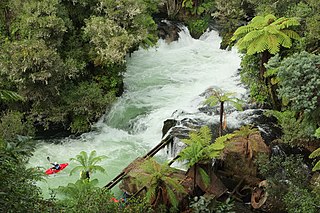
Okere Falls is a small town located 21 km from Rotorua on SH 33 between Rotorua and Tauranga on the North Island of New Zealand. The town is situated on the shore of the Okere Inlet of Lake Rotoiti, from which the Kaituna River flows north towards the Bay of Plenty.
Ngāti Pikiao is a Māori iwi of New Zealand.
Ngāti Rangitihi is a Māori iwi of New Zealand, located in the Bay of Plenty.
Ngāti Whakaue is a Māori iwi, of the Te Arawa confederation of New Zealand, tracing its descent from Whakaue Kaipapa, son of Uenuku-kopakō, and grandson of Tūhourangi. The tribe lives in the Rotorua district and descends from the Arawa waka. The Ngāti Whakaue village Ōhinemutu is within the township of Rotorua. The Ngāti Whakaue chief Pūkākī is depicted on the New Zealand 20 cent coin.
Tūhourangi is a Māori iwi of New Zealand with a rohe centered on Lake Tarawera, Lake Rotomahana, Lake Okaro, Lake Okareka, Lake Rotokākahi, Lake Tikitapu and Lake Rotorua.

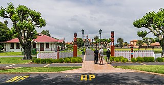
Ohinemutu or Ōhinemutu is a suburb in Rotorua, New Zealand. It includes a living Māori village and the original settlement of Rotorua.
Waitaha is a Māori iwi of New Zealand. The tribe lives in the Bay of Plenty region and descends from the Arawa waka.

Rotoiti is a settlement on the shore of Lake Rotoiti, in Rotorua Lakes within the Bay of Plenty Region of New Zealand's North Island.

Mourea is a settlement in Rotorua Lakes within the Bay of Plenty Region of New Zealand's North Island.
Ngapuna is a suburb in eastern Rotorua in the Bay of Plenty Region of New Zealand's North Island.


