Waihi Beach

Last updated

Waihi Beach
Waihi Beach.jpg
Waihi Beach
Waihi Beach
Coordinates: 37°24′40″S175°56′28″E / 37.411°S 175.941°E / -37.411; 175.941
Country New Zealand
Region Bay of Plenty
Territorial authority Western Bay of Plenty District
WardKatikati-Waihi Beach Ward
CommunityWaihi Beach Community
Electorate Coromandel
Government
  Territorial Authority Western Bay of Plenty District Council
  Regional council Bay of Plenty Regional Council
Area
[1]
  Total6.31 km2 (2.44 sq mi)
Population
 (June 2022) [2]
  Total2,760
  Density440/km2 (1,100/sq mi)

Waihi Beach is a coastal town at the western end of the Bay of Plenty in New Zealand's North Island. It lies 10 kilometres to the east of the town of Waihi, at the foot of the Coromandel Peninsula. The main beach is 10 kilometres long. The town had a permanent population of 2,760 as of June 2022.

Contents

At the northern end of Waihi Beach, the 145 hectares (360 acres) Orokawa Scenic Reserve offers several short walking tracks along the coast and to Orokawa Bay. [3] [4] While the main beach is backed by the residential area of the township of Waihi Beach, Orokawa Bay is undeveloped and surrounded by native bush including pohutukawa, puriri, and nikau palms. [4]

Anzac Bay from Bowentown lookout Anzac Bay from Bowentown.jpg
Anzac Bay from Bowentown lookout

At the southern end of the beach is the small settlement of Bowentown and the northern side of the northern Katikati entrance to Tauranga Harbour. [5]

History and culture

Early history

Māori have lived in the region since pre-European times, with numerous sites within a few kilometres of Waihi Beach. There is still evidence of the old pā sites at the Bowentown end of Waihi Beach.

The name Waihi ("Rising Water") is said to be named after a stream which flows into the beach, the later town of Waihi taking its name from the name for the beach. [6]

Modern history

The Waihi Beach Hotel was built in 1967 and the Athenree mineral hot springs are located nearby. [7] Nearby Waihi is known for the gold and silver mining operation at Martha Mine and several underground mines. [8]

Marae

Otāwhiwhi Marae, located in Bowentown, is a marae (tribal meeting ground) of the Ngāi Te Rangi tribe and Ngāi Tauwhao sub-tribe; [9] it includes the Tamaoho wharenui (meeting house). [10]

In October 2020, the Government committed $500,000 from the Provincial Growth Fund to upgrade the marae. The upgrade is expected to create 33 jobs. [11]

Demographics

Waihi Beach-Bowentown covers 6.31 km2 (2.44 sq mi) [1] and had an estimated population of 2,760 as of June 2022, [12] with a population density of 437 people per km2.

Historical population
YearPop.±% p.a.
20062,058    
20132,148+0.61%
20182,484+2.95%
Source: [13]

Waihi Beach-Bowentown had a population of 2,484 at the 2018 New Zealand census, an increase of 336 people (15.6%) since the 2013 census, and an increase of 426 people (20.7%) since the 2006 census. There were 1,029 households, comprising 1,233 males and 1,251 females, giving a sex ratio of 0.99 males per female. The median age was 54.8 years (compared with 37.4 years nationally), with 336 people (13.5%) aged under 15 years, 303 (12.2%) aged 15 to 29, 1,077 (43.4%) aged 30 to 64, and 765 (30.8%) aged 65 or older.

Ethnicities were 89.9% European/Pākehā, 14.6% Māori, 1.0% Pacific peoples, 2.5% Asian, and 1.4% other ethnicities. People may identify with more than one ethnicity.

The percentage of people born overseas was 13.9, compared with 27.1% nationally.

Although some people chose not to answer the census's question about religious affiliation, 54.1% had no religion, 34.2% were Christian, 1.7% had Māori religious beliefs, 0.7% were Hindu, 0.4% were Buddhist and 1.6% had other religions.

Of those at least 15 years old, 363 (16.9%) people had a bachelor's or higher degree, and 369 (17.2%) people had no formal qualifications. The median income was $28,600, compared with $31,800 nationally. 378 people (17.6%) earned over $70,000 compared to 17.2% nationally. The employment status of those at least 15 was that 837 (39.0%) people were employed full-time, 363 (16.9%) were part-time, and 57 (2.7%) were unemployed. [13]

Education

Waihi Beach School is a co-educational state primary school for Year to 6 students, [14] with a roll of 259 as of November 2022. [15] The school opened in 1924. [16]

Related Research Articles

<span class="mw-page-title-main">Te Kūiti</span> Town in Waikato, New Zealand

Te Kūiti is a town in the north of the King Country region of the North Island of New Zealand. It lies at the junction of State Highways 3 and 30 and on the North Island Main Trunk railway, 80 kilometres (50 mi) south of Hamilton. The town promotes itself as the sheep shearing capital of the world and is host to the annual New Zealand National Shearing Championships.

<span class="mw-page-title-main">Coromandel, New Zealand</span> Town in Waikato, New Zealand

Coromandel, also called Coromandel Town to distinguish it from the wider district, is a town on the Coromandel Harbour, on the western side of the Coromandel Peninsula, which is in the North Island of New Zealand. It is 75 kilometres east of the city of Auckland, although the road between them, which winds around the Firth of Thames and Hauraki Gulf coasts, is 190 km long. The population was 1,960 as of June 2022.

<span class="mw-page-title-main">Whakatāne</span> Town in Bay of Plenty Region, New Zealand

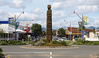
Whakatāne is the seat of the Bay of Plenty region in the North Island of New Zealand, 90 kilometres (56 mi) east of Tauranga and 89 kilometres (55 mi) north-east of Rotorua, at the mouth of the Whakatāne River. Whakatāne District is the encompassing territorial authority, which covers an area to the south and west of the town, excluding the enclave of Kawerau District.

<span class="mw-page-title-main">Morrinsville</span> Town in Waikato, New Zealand.

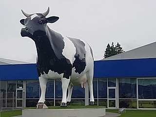
Morrinsville is a provincial town in the Waikato region of New Zealand's North Island, with an estimated population of 8,520 as of June 2022. The town is located at the northern base of the Pakaroa Range, and on the south-western fringe of the Hauraki Plains. Morrinsville is around 33 kilometres east of Hamilton and 22 kilometres west of Te Aroha. The town is bordered by the Piako River to the east and the Waitakaruru Stream to the south.

<span class="mw-page-title-main">Waihi</span> Town in Waikato region, New Zealand

Waihi is a town in Hauraki District in the North Island of New Zealand, especially notable for its history as a gold mine town.

<span class="mw-page-title-main">Bulls, New Zealand</span> Minor urban area in Manawatū-Whanganui, New Zealand

Bulls is a small town north west of Palmerston North on the west coast of the North Island of New Zealand. It is in a fertile farming area in the Rangitikei District at the junction of State Highways 1 and 3 about 135 kilometres (84 mi) north of Wellington. According to a June 2022 Statistics New Zealand estimate, Bulls has a population of 2,190 inhabitants.

<span class="mw-page-title-main">Western Bay of Plenty District</span> Territorial authority district in Bay of Plenty, New Zealand

Western Bay of Plenty District is a territorial district within the Bay of Plenty Region of New Zealand. The district envelops Tauranga City by land, and includes Matakana Island, at the entrance to Tauranga Harbour.

<span class="mw-page-title-main">Ōpōtiki</span> Town in the Bay of Plenty, New Zealand

Ōpōtiki is a town in the eastern Bay of Plenty in the North Island of New Zealand. It houses the headquarters of the Ōpōtiki District Council, the mayor of Ōpōtiki and comes under the Bay of Plenty Regional Council.

<span class="mw-page-title-main">Martinborough</span> Town in the North Island of New Zealand

Martinborough is a town in the South Wairarapa District, in the Wellington region of New Zealand. It is 65 kilometres east of Wellington and 35 kilometres south-west of Masterton. The town has a resident population of 2,000.

<span class="mw-page-title-main">Katikati</span> Town in the Bay of Plenty, New Zealand

Katikati is a town in New Zealand located on the Uretara Stream near a tidal inlet towards the northern end of Tauranga Harbour, 28 kilometres south of Waihi and 40 kilometres northwest of Tauranga. State Highway 2 passes through the town; a bypass scheduled to have begun construction in 2008 is on hold.

<span class="mw-page-title-main">Matakana Island</span> Island in the Bay of Plenty, New Zealand

Matakana Island is located in the western Bay of Plenty in New Zealand's North Island. A long, flat barrier island, it is 20 kilometres (12 mi) in length but rarely more than 3 kilometres (1.9 mi) wide. The island has been continuously populated for centuries by Māori tribes that are mostly associated with Ngāi Te Rangi.

<span class="mw-page-title-main">Murupara</span> Town in Bay of Plenty Region, New Zealand

Murupara is a town located in the Whakatāne District and Bay of Plenty Region of New Zealand's North Island. The town is situated in an isolated part of the region between the Kaingaroa Forest and Te Urewera protected area, on the banks of the Rangitaiki River, 65 kilometres southeast of Rotorua. Indigenous Māori also make up over 90% of the total population.

Ngongotahā is a town on the western shores of Lake Rotorua in New Zealand's North Island. It is 10 kilometers northwest of Rotorua city, and is part of the Rotorua metropolitan area. Its population was 5,180 as of June 2022.

<span class="mw-page-title-main">Te Kauwhata</span> Town in Waikato, New Zealand

Te Kauwhata is a small town in the north of the Waikato region of New Zealand, situated close to the western shore of Lake Waikare, some 40 km north of Hamilton and approximately 58 km south of Manukau City.

<span class="mw-page-title-main">Ōpunake</span> Minor urban area in Taranaki, New Zealand

Ōpunake is a small town on the southwest coast of Taranaki in New Zealand's North Island. It is located 45 kilometres southwest of New Plymouth. Rahotu is 16 km to the northwest. Manaia is 29 km to the southeast. State Highway 45 passes through the town. The town has a population of 1,430.

<span class="mw-page-title-main">Kawakawa, New Zealand</span> Town in Northland, New Zealand

Kawakawa is a small town in the Bay of Islands area of the Northland Region of New Zealand. Kawakawa developed as a service town when coal was found there in the 1860s, but coal mining ceased in the early 20th century. The economy is now based on farming. The town is named after the kawakawa shrub.

<span class="mw-page-title-main">Moerewa</span> Place in Northland Region, New Zealand

Moerewa is a small town in the Northland Region of the North Island of New Zealand. It is located close to the Bay of Islands five kilometres to the west of Kawakawa.

<span class="mw-page-title-main">Maketu</span> Town in the Bay of Plenty, New Zealand

Maketu is a small town on the Bay of Plenty Coast in New Zealand.

<span class="mw-page-title-main">Opua</span> Place in Northland Region, New Zealand

Opua is a locality in the Bay of Islands, in the sub-tropical Northland Region of New Zealand. It is notable as the first port for overseas yachts arriving in the country after crossing the Pacific Ocean. In the original 1870s plans for the town, it was named Newport. The town of Paihia is nearby, and the small settlement of Te Haumi is in between.

<span class="mw-page-title-main">Kaiti, New Zealand</span> Suburb of Gisborne, New Zealand

Kaiti is a suburb of the New Zealand city of Gisborne. It is located immediately to the east of the city centre, on the opposing bank of the Waimata River.

References

  1. 1 2 "ArcGIS Web Application". statsnz.maps.arcgis.com. Retrieved 22 November 2022.
  2. "Subnational population estimates (RC, SA2), by age and sex, at 30 June 1996-2022 (2022 boundaries)". Statistics New Zealand . Retrieved 25 October 2022. (regional councils); "Subnational population estimates (TA, SA2), by age and sex, at 30 June 1996-2022 (2022 boundaries)". Statistics New Zealand . Retrieved 25 October 2022. (territorial authorities); "Subnational population estimates (urban rural), by age and sex, at 30 June 1996-2022 (2022 boundaries)". Statistics New Zealand . Retrieved 25 October 2022. (urban areas)
  3. "Orokawa Bay". Waihi Beach Community Events & Promotions Inc. Retrieved 6 September 2014.
  4. 1 2 "Tauranga area: Orokawa Scenic Reserve short walking tracks". Department of Conservation NZ . Retrieved 6 September 2014.
  5. "Bay of Plenty places - Waihī Beach to Bowentown". Te Ara: Encyclopedia of New Zealand. 14 November 2012. Retrieved 6 September 2014.
  6. "History of Waihi Beach". Ohinemuri Regional History Journal 9, May 1968. Retrieved 6 September 2014.
  7. "Why Waihi? Why not?". Waikato Times. 20 January 2014. Retrieved 6 September 2014.
  8. "History - Newmont Waihi Gold". Newmont Mining Corporation . Retrieved 6 September 2014.
  9. "Te Kāhui Māngai directory". tkm.govt.nz. Te Puni Kōkiri.
  10. "Māori Maps". maorimaps.com. Te Potiki National Trust.
  11. "Marae Announcements" (Excel). growregions.govt.nz. Provincial Growth Fund. 9 October 2020.
  12. "Population estimate tables - NZ.Stat". Statistics New Zealand . Retrieved 25 October 2022.
  13. 1 2 "Statistical area 1 dataset for 2018 Census". Statistics New Zealand. March 2020. Waihi Beach-Bowentown (190200). 2018 Census place summary: Waihi Beach-Bowentown
  14. "Waihi Beach School Ministry of Education School Profile". educationcounts.govt.nz. Ministry of Education.
  15. "Waihi Beach School Education Review Office Report". ero.govt.nz. Education Review Office.
  16. "Waihi Beach School 75th Jubilee". Ohinemuri Regional History Journal (44). September 2000.

Coordinates: 37°24′S175°56′E / 37.400°S 175.933°E / -37.400; 175.933