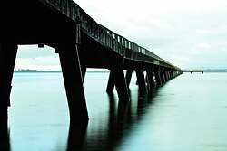
The Kaimai Range is a mountain range in the North Island of New Zealand. It is part of a series of ranges, with the Coromandel Range to the north and the Mamaku Ranges to the south. The Kaimai Range separates the Waikato in the west from the Bay of Plenty in the east.

Coromandel, also called Coromandel Town to distinguish it from the wider district, is a town on the Coromandel Harbour, on the western side of the Coromandel Peninsula, which is in the North Island of New Zealand. It is 75 kilometres east of the city of Auckland, although the road between them, which winds around the Firth of Thames and Hauraki Gulf coasts, is 190 km long. The population was 1,890 as of June 2021.
Takaanini is a southern suburb of Auckland, in northern New Zealand. It is located on the shores of the Pahurehure Inlet, 28 kilometres southeast of the Auckland CBD.

Western Bay of Plenty District is a territorial authority within the Bay of Plenty Region of New Zealand. The district envelops Tauranga City by land, and includes Matakana Island, at the entrance to Tauranga Harbour.

Chatswood is a suburb in the city of Auckland, New Zealand, in the middle-eastern side of North Shore. It contains a primary school and many parks. To the south of Chatswood is Kendall's Bay, a small bay of the Waitematā Harbour. The suburb is under the governance of Auckland Council. The Royal New Zealand Navy's Kauri Point Armament Depot is located in Chatswood. Chelsea Sugar Refinery is located in Chatswood.

Maketu is a small town on the Bay of Plenty Coast in New Zealand.
Oropi is a rural settlement located in the Bay of Plenty region of the North Island of New Zealand. It is located 20 kilometres south of Tauranga and 43 kilometres north of Rotorua. It has been suggested that the word Oropi is the Māori language equivalent of Europe. This is derived from the 1860s when government forces were based in the area at the time of the Battle of Gate Pā.

Ōmokoroa is a small urban area in the Western Bay of Plenty District of New Zealand. The suburb is considered part of Greater Tauranga, and is within the Coromandel electorate. Ōmokoroa began as a small rural holiday village, but is expanding to be a commuter town, with a 25-minute drive to Tauranga City.

Galatea is a settlement in the Whakatāne District in the Bay of Plenty region of the North Island of New Zealand.

Wharekahika or Hicks Bay is a bay and coastal area in the Gisborne District of the North Island of New Zealand. It is situated 150 km east of Opotiki and 186 km north of Gisborne city, along State Highway 35 between Potaka and Te Araroa.

Marsden Bay is a locality and bay at the south head of Whangārei Harbour in Northland, New Zealand. The western side of Marsden Bay is a coastal community called One Tree Point, and the eastern side is the industrial development of Marsden Point. Ruakākā lies about 9 km to the south.
Turakina is an old Māori settlement situated southeast of Whanganui city on the North Island of New Zealand. Turakina village derives its name from the Turakina River, which cut its passage to the sea from a source south of Waiouru.

Pukehina is a beach and township located in the Western Bay of Plenty District and Bay of Plenty Region of New Zealand's North Island. It consists of a white sandy beach, an estuary, farms and several homes. The area is popular with surfing, windsurfing and kite surfing. There is a campground located at the south-eastern end of the beach, and a boat ramp at the estuary.
Koutu is a suburb of Rotorua in the Bay of Plenty Region of New Zealand's North Island.
Merivale or Parkvale is a suburb of Tauranga, in the Bay of Plenty Region of New Zealand's North Island.
Aongatete is a settlement and rural community in the Western Bay of Plenty District and Bay of Plenty Region of New Zealand's North Island. It is located on State Highway 2, south of Katikati and north-west of Omokoroa. The landscape consists of a long valley descending into the Tauranga Harbour.
Minden is a rural community in the Western Bay of Plenty District and Bay of Plenty Region of New Zealand's North Island. The peak that the area is named after was named after the 1759 Battle of Minden in Prussia by a soldier stationed in Tauranga in 1866 after the Tauranga campaign.
Kopurererua is a rural community in the upper valley of the Kopurererua Stream in the Western Bay of Plenty District and Bay of Plenty Region of New Zealand's North Island. The lower Kopurererua valley is in Tauranga.
Otawa is a rural area in the Western Bay of Plenty District and Bay of Plenty Region of New Zealand's North Island. The Otawa Scenic Reserve has several walking tracks varying between 30 minutes and four hours return. The tracks are described as advanced. The peak of Otawa is 565 metres.
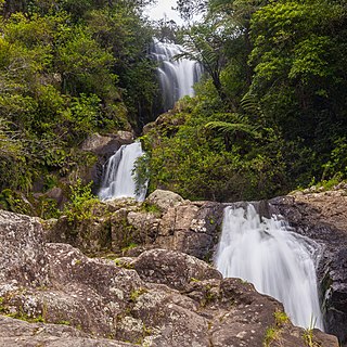
Kaitemako is a rural area in the Western Bay of Plenty District and Bay of Plenty Region of New Zealand's North Island. The area includes the Kaitemako Stream catchment. The highest point is Pukunui at 364 metres. The Kaiate Falls are a pair of waterfalls, with the lower fall being about 15 metres high.