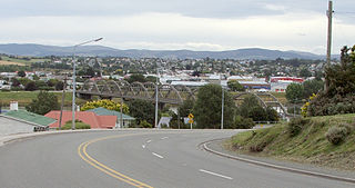
Ōmokoroa is a small urban area in the Western Bay of Plenty District of New Zealand. The suburb is considered part of Greater Tauranga (contributing towards its population of 158,300), and is within the Coromandel electorate.[3] Ōmokoroa began as a small rural holiday village, but is expanding to be a commuter town, with a 25-minute drive to Tauranga City.
Ōmokoroa urban area had a population of 3210 as of 2018, and is designated as an area of special housing growth. With the rural area to the south, it is expected to reach a population of 12,000 by 2020–2030, and is situated within the Kaimai Ward, Western Bay of Plenty. Ōmokoroa includes the urban area on the harbour side of State Highway 2, along with Youngson Road to Plummers Point Road, and parts of Old Highway Road.
Demographics
Omokoroa statistical area corresponds to the more built-up northern part of the peninsula, separated from the more rural area to the south by the East Coast Main Trunk. It covers 3.83km2 (1.48sqmi)[1] and had an estimated population of 3,990 as of June 2022,[4] with a population density of 1,042 people per km2.
Omokoroa had a population of 3,210 at the 2018 New Zealand census, an increase of 876 people (37.5%) since the 2013 census, and an increase of 1,242 people (63.1%) since the 2006 census. There were 1,314 households, comprising 1,533 males and 1,677 females, giving a sex ratio of 0.91 males per female. The median age was 58.0 years (compared with 37.4 years nationally), with 507 people (15.8%) aged under 15 years, 237 (7.4%) aged 15 to 29, 1,182 (36.8%) aged 30 to 64, and 1,287 (40.1%) aged 65 or older.
Ethnicities were 95.0% European/Pākehā, 7.3% Māori, 0.8% Pacific peoples, 2.0% Asian, and 1.5% other ethnicities. People may identify with more than one ethnicity.
The percentage of people born overseas was 24.9, compared with 27.1% nationally.
Although some people chose not to answer the census's question about religious affiliation, 48.3% had no religion, 42.9% were Christian, 0.6% had Māori religious beliefs, 0.1% were Hindu, 0.2% were Muslim, 0.3% were Buddhist and 1.0% had other religions.
Of those at least 15 years old, 567 (21.0%) people had a bachelor's or higher degree, and 453 (16.8%) people had no formal qualifications. The median income was $29,200, compared with $31,800 nationally. 453 people (16.8%) earned over $70,000 compared to 17.2% nationally. The employment status of those at least 15 was that 903 (33.4%) people were employed full-time, 369 (13.7%) were part-time, and 51 (1.9%) were unemployed.[5]
Rural surrounds
Omokoroa Rural includes the area between State Highway2 and the East Coast Main Trunk, and also includes Plummers Point. It covers 7.91km2 (3.05sqmi)[1] and had an estimated population of 1,520 as of June 2022,[4] with a population density of 192 people per km2.
Omokoroa Rural had a population of 744 at the 2018 New Zealand census, an increase of 105 people (16.4%) since the 2013 census, and an increase of 48 people (6.9%) since the 2006 census. There were 279 households, comprising 357 males and 384 females, giving a sex ratio of 0.93 males per female. The median age was 48.8 years (compared with 37.4 years nationally), with 132 people (17.7%) aged under 15 years, 114 (15.3%) aged 15 to 29, 345 (46.4%) aged 30 to 64, and 150 (20.2%) aged 65 or older.
Ethnicities were 93.1% European/Pākehā, 10.9% Māori, 1.2% Pacific peoples, 1.2% Asian, and 2.0% other ethnicities. People may identify with more than one ethnicity.
The percentage of people born overseas was 15.7, compared with 27.1% nationally.
Although some people chose not to answer the census's question about religious affiliation, 50.0% had no religion, 36.3% were Christian, 0.4% had Māori religious beliefs, 0.4% were Hindu, 0.4% were Buddhist and 2.8% had other religions.
Of those at least 15 years old, 120 (19.6%) people had a bachelor's or higher degree, and 78 (12.7%) people had no formal qualifications. The median income was $34,800, compared with $31,800 nationally. 114 people (18.6%) earned over $70,000 compared to 17.2% nationally. The employment status of those at least 15 was that 276 (45.1%) people were employed full-time, 141 (23.0%) were part-time, and 12 (2.0%) were unemployed.[6]
Omokoroa No.1 School is a co-educational state primary school for Year 1 to 8 students,[8][9] with a roll of 315 as of July 2022.[10]
Omokoroa Point School is another co-educational state primary school for Year 1 to 8 students,[11] with a roll of 335.[12]
The nearest zoned secondary schools in the area are Otumoetai College, Tauranga Boys' College and Tauranga Girls' College. Katikati College and the private Bethlehem College are also nearby.[13]
Dannevirke, is a rural service town in the Manawatū-Whanganui region of the North Island, New Zealand. It is the major town of the administrative of the Tararua District, the easternmost of the districts of which the Horizons Regional Council has responsibilities.
Balclutha is a town in South Otago, lying towards the end of the Clutha River, on the east coast of the South Island of New Zealand. It is about halfway between Dunedin and Gore on the Main South Line railway, State Highway 1 and the Southern Scenic Route. Balclutha has a population of 4,300, and is the largest town in South Otago.
Whakatāne is the seat of the Bay of Plenty region in the North Island of New Zealand, 90 kilometres (56 mi) east of Tauranga and 89 kilometres (55 mi) north-east of Rotorua, at the mouth of the Whakatāne River. Whakatāne District is the encompassing territorial authority, which covers an area to the south and west of the town, excluding the enclave of Kawerau District.
Te Awamutu is a town in the Waikato region in the North Island of New Zealand. It is the council seat of the Waipa District and serves as a service town for the farming communities which surround it. Te Awamutu is located some 30 kilometres (19 mi) south of Hamilton on State Highway 3, one of the two main routes south from Auckland and Hamilton.
Morrinsville is a provincial town in the Waikato region of New Zealand's North Island, with an estimated population of 8,520 as of June 2022. The town is located at the northern base of the Pakaroa Range, and on the south-western fringe of the Hauraki Plains. Morrinsville is around 33 kilometres east of Hamilton and 22 kilometres west of Te Aroha. The town is bordered by the Piako River to the east and the Waitakaruru Stream to the south.
Bulls is a small town north west of Palmerston North on the west coast of the North Island of New Zealand. It is in a fertile farming area in the Rangitikei District at the junction of State Highways 1 and 3 about 135 kilometres (84 mi) north of Wellington. According to a June 2022 Statistics New Zealand estimate, Bulls has a population of 2,190 inhabitants.
Ōpōtiki is a town in the eastern Bay of Plenty in the North Island of New Zealand. It houses the headquarters of the Ōpōtiki District Council and comes under the Bay of Plenty Regional Council.
Kawerau is a town in the Bay of Plenty region of the North Island of New Zealand. It is situated 100 km south-east of Tauranga and 58 km east of Rotorua. It is the seat of the Kawerau District Council, and the only town in Kawerau District.
Martinborough is a town in the South Wairarapa District, in the Wellington region of New Zealand. It is 65 kilometres east of Wellington and 35 kilometres south-west of Masterton. The town has a resident population of 2,000.
Richmond is a town and the seat of the Tasman District Council in New Zealand. It lies 13 kilometres (8 mi) south of Nelson in the South Island, close to the southern extremity of Tasman Bay / Te Tai-o-Aorere. The town, first settled by Europeans in 1842, was named in 1854 after the town of Richmond on Thames near London. The town has an estimated population of 18,450 as of June 2022.
Clyde, formerly Dunstan, is a small town in Central Otago, New Zealand with a population of 1,270 in June 2022. It is located on the Clutha River, between Cromwell and Alexandra.
Katikati is a town in New Zealand located on the Uretara Stream near a tidal inlet towards the northern end of Tauranga Harbour, 28 kilometres south of Waihi and 40 kilometres northwest of Tauranga. State Highway 2 passes through the town; a bypass scheduled to have begun construction in 2008 is on hold.
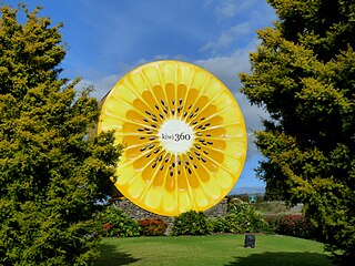
Te Puke is a town located 18 kilometres southeast of Tauranga in the Western Bay of Plenty of New Zealand. It is particularly well-known for the cultivation of Kiwifruit.
Murupara is a town located in the Whakatāne District and Bay of Plenty Region of New Zealand's North Island. The town is situated in an isolated part of the region between the Kaingaroa Forest and Te Urewera protected area, on the banks of the Rangitaiki River, 65 kilometres southeast of Rotorua.
Waihi Beach is a coastal town at the western end of the Bay of Plenty in New Zealand's North Island. It lies 10 kilometres to the east of the town of Waihi, at the foot of the Coromandel Peninsula. The main beach is 10 kilometres long. The town had a permanent population of 2,760 as of June 2022.
Ngongotahā is a town on the western shores of Lake Rotorua in New Zealand's North Island. It is 10 kilometers northwest of Rotorua city, and is part of the Rotorua metropolitan area. Its population was 4,107 in the 2013 census.
Clive is a small town, ten kilometres from the city centres of both Napier and Hastings in the Hawke's Bay region of New Zealand's North Island. It is close to the mouth of the Ngaruroro River.
Ashhurst is a town and outlying suburb of Palmerston North, in the Manawatū-Whanganui region of New Zealand's North Island.
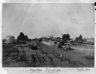
Marton is a town in the Rangitikei district of the Manawatū-Whanganui region of New Zealand's North Island. It is situated 35 kilometres southeast of Whanganui and 40 kilometres northwest of Palmerston North.
Aongatete is a settlement and rural community in the Western Bay of Plenty District and Bay of Plenty Region of New Zealand's North Island. It is located on State Highway 2, south of Katikati and north-west of Ōmokoroa. The landscape consists of a long valley descending into the Tauranga Harbour.
This page is based on this Wikipedia article Text is available under the CC BY-SA 4.0 license; additional terms may apply. Images, videos and audio are available under their respective licenses.