
Wiltshire is a ceremonial county in South West England. It borders Gloucestershire to the north, Oxfordshire to the north-east, Berkshire to the east, Hampshire to the south-east, Dorset to the south, and Somerset to the west. The largest settlement is Swindon, and Trowbridge is the county town.

A roundabout, a rotary and a traffic circle are types of circular intersection or junction in which road traffic is permitted to flow in one direction around a central island, and priority is typically given to traffic already in the junction.

Swindon is a large town in Wiltshire, England. At the time of the 2021 Census the population of the built-up area was 183,638, making it the largest settlement in the county. Located in South West England, Swindon lies on the M4 corridor, 71 miles (114km) to the west of London and 36 miles to the east of Bristol. The Cotswolds lie just to the town's north and the North Wessex Downs to its south.

The Wilts & Berks Canal is a canal in the historic counties of Wiltshire and Berkshire, England, linking the Kennet and Avon Canal at Semington near Melksham, to the River Thames at Abingdon. The North Wilts Canal merged with it to become a branch to the Thames and Severn Canal at Latton near Cricklade. Among professional trades boatmen, the canal was nicknamed the Ippey Cut, possibly short for Chippenham.

The A52 is a major road in the East Midlands, England. It runs east from a junction with the A53 at Newcastle-under-Lyme near Stoke-on-Trent via Ashbourne, Derby, Stapleford, Nottingham, West Bridgford, Bingham, Grantham, Boston and Skegness to the east Lincolnshire coast at Mablethorpe. It is approximately 147 miles (237 km) long.

Melksham Without is a civil parish in the county of Wiltshire, England. It surrounds, but does not include, the town of Melksham and is the largest rural parish in Wiltshire, with a population of 7,230 and an area of 29 square kilometres. The parish includes the villages of Beanacre, Berryfield, Shaw and Whitley, and the hamlets of Outmarsh and Redstocks. It also includes the outer Melksham suburbs of Bowerhill and The Spa, and the dispersed settlement of Sandridge which includes Sandridge Common.
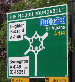
"The Magic Roundabout" in Hemel Hempstead, Hertfordshire, England, is the familiar name given to the Plough Roundabout. The familiar name comes from the children's television programme, and is also used for a similar junction in Swindon, the M40 junction in Denham, and the Magic Roundabout in Colchester. The official name relates to a former public house, called The Plough Inn, which was between the junction of what is now Selden Hill and St Albans Road. It has also been known as the Moor End Roundabout as it is adjacent to the part of Boxmoor nearest the town. Before Hemel Hempstead became a new town the roads met in a simple junction which was then replaced by a standard roundabout.
The Denham Roundabout is a road junction in Denham, Buckinghamshire. It was originally opened in 1943 in conjunction with the completion of the new Western Avenue route into west London. The Western Avenue took over the classification of the A40, with the previous route to London, via Uxbridge and Ealing, being reclassified as the A4020. The roundabout also included a new link to A412 that formed part of the outer London orbital route.

Royal Wootton Bassett, formerly Wootton Bassett, is a market town and civil parish in Wiltshire, England, with a population of 13,570 at the 2021 Census. In the north of the county, it lies 6 miles (10 km) to the west of the town of Swindon and 10 miles (16 km) northeast of Calne.

The A594 Central Ring is Leicester's central distributor road network.

Coate Water is a country park situated 5 km (3.1 mi) to the southeast of central Swindon, England, near junction 15 of the M4. It takes its name from its main feature, a reservoir originally built to provide water for the Wilts & Berks Canal. Now named 'Coate Water Country Park', the lake and its surroundings are both a leisure facility and a nature reserve.

Bourton is a village and civil parish in the Vale of White Horse, England, about 4 miles (6.4 km) southeast of Highworth in neighbouring Wiltshire. Bourton was part of the parish of Shrivenham until 1867, and was in Berkshire until the 1974 local government boundary changes transferred the Vale of White Horse to Oxfordshire. The 2011 Census recorded the parish population as 326.
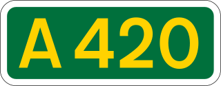
The A420 is a road between Bristol and Oxford in England. Between Swindon and Oxford it is a primary route.

Pewsham is a small village and former civil parish just south-east of the town of Chippenham on the A4 national route towards Calne in Wiltshire, England.

Swindon is a town in Wiltshire in the South West of England. People have lived in the town since the Bronze Age and the town's location, being approximately halfway between Bristol and London, made it an ideal location for the Locomotive Factories of the Great Western Railway in the 19th century.

The Greenstead roundabout is a large roundabout junction in Colchester, Essex, England.
Transport in Swindon, England, and the surroundings has directly contributed to the town's growth and the ingress of businesses and industries.

The A6177 is a ring road around Bradford in West Yorkshire, England. It is mostly formed from existing roads and save for its southern section is single-carriageway.

Berryfield is a small village to the south of the town of Melksham, in Wiltshire, England. The village is separated from the southwestern outskirts of Melksham by the A350 road and about 500 metres of farmland; it falls within the civil parish of Melksham Without. The Bristol Avon is about 0.6 miles (1 km) west of the village. Although close to Melksham town, Berryfield remains a separate community.

Wichelstowe is a residential development and urban extension on the southern edge of the town of Swindon in South West England, constructed from late 2006. Located north of the M4 motorway between junction 16 and Croft Road, Wichelstowe has three neighbourhoods: East, Middle and West Wichel. The development will comprise up to 4500 homes, employment space, public open space, shopping, community facilities for residents and various schools. In 2014 it was described as the country's largest housing project on public-owned land.


