Knockacarracoush or Knockacarracoosh is a small townland situated in north County Cork, Ireland, west of Kanturk and north of Millstreet. It is in the parish of Dromtarriff and also borders the parishes of Cullen and Boherbue. It has 14 inhabitants and consists of three farms and four houses.
A townland is a small geographical division of land, historically and currently used in Ireland and in the Western Isles in Scotland, typically covering 100–500 acres (40–202 ha). The townland system is of Gaelic origin, antedating the Norman invasion, and most have names of Irish origin. However, some townland names and boundaries come from Norman manors, plantation divisions, or later creations of the Ordnance Survey. The total number of inhabited townlands in Ireland was 60,679 in 1911. The total number recognised by the Irish Place Names database as of 2014 was 61,098, including uninhabited townlands, mainly small islands.
Ballyveelick is a townland in the civil parish of Castletownroche, County Cork, Ireland. It is 0.7 square kilometres (0.3 sq mi) in area, and had a population of 5 people as of the 2011 census.

Ballymacelligott is a civil parish in the north of County Kerry in Ireland. It is situated 7 kilometres (4.3 mi) east of Tralee in the historical barony of Trughanacmy.
Coolgarriv is a townland on the outskirts of Killarney, County Kerry, Ireland. It is located on Madam's Hill, overlooking Killarney in the nearby valley. It is bordered by Aghadoe and Knockasarnett townlands. Coolgarriv is part of Fossa parish, in the Diocese of Kerry.

Farran is a village in County Cork, Ireland, in the parish of Ovens. It lies on the southside of the River Lee. Farran is 12 miles (19 km) west from Cork City on the N22 road.
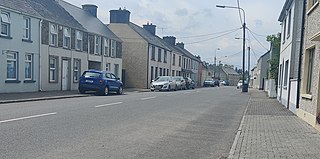
Boherbue or Boherboy is a village in north-west County Cork, Ireland. The village is in the civil parish of Kilmeen in the Barony of Duhallow, and spans the townlands of Gneeves, Laharan and Derrynatubbrid. Boherbue is within the Cork North-West Dáil constituency.
Ballyvoige is a townland in the civil parish of Desertserges, County Cork, Ireland.

Dunhill is a village, townland and civil parish in County Waterford, Ireland. It comprises a church, a primary school, a parish hall, a public house and shop. An enterprise park called Dunhill Ecopark was established in 2000 by members of the Dunhill community.

Firies is a village in County Kerry, Ireland in the barony of Magunihy. It is situated midway between the hub towns of Killarney (14.5 km), Tralee (16 km), Castleisland (16 km) and Killorglin (13 km). It is on the R561 road between Farranfore and Castlemaine. The population at the 2016 census was 558. There are two principal rivers, namely the Maine and its chief tributary, the Brown Flesk.
Crusheen, formerly called Inchicronan, is a civil parish in County Clare, Ireland. There is also a catholic parish Crusheen, covering the same area. The parish lies to the northeast of Ennis. It contains the villages of Crusheen and Ballinruan.
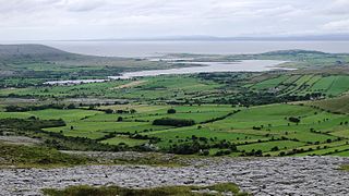
Oughtmama is a civil parish in County Clare. It lies in the Burren, a region in the northwest of the county. It contains many antiquities, including three early-medieval Christian churches, ruined castles, prehistoric cairns and ring forts and two Martello Towers built in the early 19th century.

Kilcorney is a civil parish in County Clare, Ireland. It lies in the Burren region of the northwest of the county.

Cloonnafinneela is a townland of County Kerry, Ireland.

Ballyconnell, is a townland of County Kerry, Ireland.

Castletown, is a townland of County Kerry, Ireland.

Glanballyma, is a townland of County Kerry, Ireland.

Knockbrack East, is a townland of County Kerry, Ireland.
Tooreen, is a townland of County Kerry, Ireland.

Knocknahila, is a townland of County Kerry, Ireland. It has no confirmed Irish translation.
