


Magnolia is a farming and ranching community located within Parkland County in the Canadian province of Alberta. It is on the west end of Isle Lake and east of the Pembina River in west-central Alberta.
Magnolia is a farming and ranching community located within Parkland County in the Canadian province of Alberta. It is on the west end of Isle Lake and east of the Pembina River in west-central Alberta.
Both the Foley Trail and the Yellowhead Trail, fur trade routes, passed through this area. [1] In the 1860s Pierre and Marie Grey established their stopping house and independent trading post on the northwest corner of Isle Lake (also known as Lake Isle) . [2] In 1905, Swedish homesteaders arrived in the area. The first post office was also opened in 1908. The Magnolia School was opened in 1911 and operated until 1948. [3] The Magnolia Community Hall is the only public building on the old Magnolia townsite. On May 29, 1982, Magnolia was hit by an F0 tornado.
In 1908, the Canadian Northern Railway was built roughly along the Yellowhead Trail route and a railway station was established at Magnolia. [2] The Grand Trunk Pacific Railway was built on a path through Stony Plain and Wabamun, coming around the south side of Isle Lake, passing over the Magnolia Bridge, two miles south of the Magnolia townsite. The two railways ran in parallel west of Magnolia. The Canadian Northern Railway tracks were eventually torn out. The Magnolia Bridge was converted from wood to steel and is used by Canadian National Railways.
The Magnolia area is hilly, with gravel moraines left by retreating ice sheets. [2] There are areas of muskeg. Creeks and rivers feed into Round Lake and Isle Lake. [4] The Sturgeon River flows under the Magnolia Bridge before it reaches Isle Lake.

Crowsnest Pass is a low mountain pass across the Continental Divide of the Canadian Rockies on the Alberta–British Columbia border.

Jasper is a specialized municipality and townsite in western Alberta within the Canadian Rockies. The townsite is in the Athabasca River valley and is the commercial centre of Jasper National Park.
The Canadian Northern Railway (CNoR) was a historic Canadian transcontinental railway. At its 1923 merger into the Canadian National Railway, the CNoR owned a main line between Quebec City and Vancouver via Ottawa, Winnipeg, and Edmonton.

Barrhead is a town in central Alberta, Canada that is surrounded by the County of Barrhead No. 11. It is located along the Paddle River and at the intersection of Highway 33 and Highway 18, approximately 120 km (75 mi) northwest of the City of Edmonton. It is also located along the route of the Express Trail, used by the North West Company, which was originally a First Nations trail. The trail was later widened by George Simpson and John Rowand to save the North West Company over $5,000.
Vermilion is a town in central Alberta, Canada that is surrounded by the County of Vermilion River. It is at the intersection of Highway 16 and Highway 41, approximately 60 kilometres (37 mi) west of Lloydminster and 192 kilometres (119 mi) east of Edmonton.
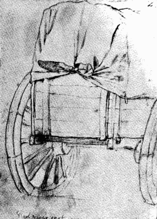
The Red River cart is a large two-wheeled cart made entirely of non-metallic materials. Often drawn by oxen, though also by horses or mules, these carts were used throughout most of the 19th century in the fur trade and in westward expansion in Canada and the United States, in the area of the Red River and on the plains west of the Red River Colony. The cart is a simple conveyance developed by Métis for use in their settlement on the Red River in what later became Manitoba. With carts, the Metis were not restricted to river travel to hunt bison. The Red River cart was largely responsible for commercializing the buffalo hunt.
Alberta Provincial Highway No. 16, commonly referred to as Highway 16, is a major east–west highway in central Alberta, Canada, connecting Jasper to Lloydminster via Edmonton. It forms a portion of the Yellowhead Highway, a major interprovincial route of the Trans-Canada Highway system that stretches from Masset, British Columbia, to Portage la Prairie, Manitoba, near Winnipeg. Highway 16 spans approximately 634 km (394 mi) from Alberta's border with British Columbia in the west to its border with Saskatchewan in the east. As of 2010, all but less than 96 km (60 mi) of the route was divided, with a minimum of two lanes in each direction. It is designated a core route in Canada's National Highway System.
Fort Assiniboine is a hamlet in northwest Alberta, Canada, within Woodlands County. It is located along the north shore of the Athabasca River at the junction of Highway 33 and Highway 661. It is approximately 39 kilometres (24 mi) northwest of Barrhead, 62 kilometres (39 mi) southeast of Swan Hills and 91 kilometres (57 mi) northeast of Whitecourt.
Highway 16 is a provincial highway in the Canadian province of Saskatchewan. It is the Saskatchewan section of the Yellowhead Highway, and also the Trans-Canada Highway Yellowhead section. The main purpose of this highway is to connect Saskatchewan with Canadian cities such as Edmonton and Winnipeg. The highway runs from the Alberta boundary in Lloydminster to the Manitoba boundary near Marchwell. Major cities it passes through are Saskatoon, North Battleford in the central part of the province, Yorkton in the far east and Lloydminster to the far west.

Entwistle is a hamlet in Alberta, Canada, within Parkland County. It is at the Yellowhead Highway's intersection with Highway 22/Highway 16A, approximately 95 kilometres (59 mi) west of Edmonton. It sits on the east banks of the Pembina River near the halfway point between Edmonton and Edson.

Highway 16A is the designation of three alternate routes off Alberta Highway 16 in Alberta, Canada. The Evansburg – Entwistle section is called 16A:08 by Alberta Transportation, while 16A:24 runs through Vegreville. The section west of Edmonton is labelled 16A:14 and 16A:16 on Alberta Transportation maps, but is better known as Parkland Highway and Stony Plain Road.

The Municipal District of Greenview No. 16 is a municipal district (MD) in northwest Alberta, Canada. It covers the full extent of Census Division 18, and with an area of 32,984 km2 (12,735 sq mi), it is the largest municipal district in Alberta. Its administrative office is located in the Town of Valleyview.

The Pembina River is a tributary of the Athabasca River in central Alberta, Canada. "Pembina" is an Indigenous word "Pimbina" (Cree) for the high bush cranberry or summerberry (Viburnum trilobum). The river gives the name to the Pembina oil field, an oil- and gas-producing region centered on Drayton Valley. The environmentalist group Pembina Institute also took its name from the river.
Central Alberta is a region located in the Canadian province of Alberta.

Wildwood is a hamlet in west-central Alberta, Canada within Yellowhead County. It is on the Yellowhead Highway, approximately 112 kilometres (70 mi) west of Edmonton and 82 kilometres (51 mi) east of Edson. The Yellowhead Highway's intersection with Cowboy Trail is 9 kilometres (5.6 mi) east of the hamlet. The Lobstick River, which flows from Chip Lake to the west, runs through the hamlet.

The Red Coat Trail is a 1,300-kilometre (810 mi) route that approximates the path taken in 1874 by the North-West Mounted Police in their March West from Fort Dufferin to Fort Whoop-Up.
Darwell is a hamlet in central Alberta, Canada that is under the jurisdiction of Lac Ste. Anne County. It is 10 kilometres (6.2 mi) north of Highway 16, 74 kilometres (46 mi) northwest of Edmonton.

Lake Isle is an unincorporated community in central Alberta, Canada within Lac Ste. Anne County. It is located on the shore of Isle Lake, 7 kilometres (4.3 mi) north of Highway 16, and approximately 82 kilometres (51 mi) west of Edmonton.
Ballantine is a locality located within Lac Ste. Anne County in the Canadian province of Alberta. It is located between Oldman Lake and the Pembina River, approximately 23 km (14 mi) southwest of Barrhead.
Matthews Crossing is a river crossing on the Pembina River in the Canadian province of Alberta approximately 10 km (6.2 mi) downstream from Entwistle.