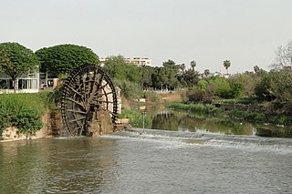
The Orontes or Nahr al-ʿĀṣī, or simply Asi is a 571 kilometres (355 mi) long river in Western Asia that begins in Lebanon, flowing northwards through Syria before entering the Mediterranean Sea near Samandağ in Hatay Province, Turkey.

Mharda, also spelled Mhardeh, Muhardah or Mahardah, is a city in northern Syria, administratively part of the Hama Governorate, located about 23 kilometers northwest of Hama. It is situated along the Orontes River, near the Ghab plain. Nearby localities include Halfaya and Taybat al-Imam to the east, Khitab to the southeast, Maarzaf to the south, Asilah and Jubb Ramlah to the southwest, Shaizar, Safsafiyah, Tremseh and Kafr Hud to the west and Kafr Zita and al-Lataminah to the north.

Hama Governorate is one of the 14 governorates of Syria. It is situated in western-central Syria, bordering Idlib and Aleppo Governorates to the north, Raqqa Governorate to the east, Homs Governorate to the south, and Tartus and Latakia Governorate to the west. It is the only Governorate that does not border a foreign country. Measures of its area vary from 8,844 km2 to 8,883 km2, with its capital being the city of Hama.

Kafr Buhum, is a town in central Syria, administratively part of the Hama Governorate, located 9 km southwest of Hama, 210 km (130 mi) north Damascus and 160 km (99 mi) south of Aleppo. Nearby localities include al-Rabiaa and Matnin to the northwest, Tayzin to the north, al-Khalidiyah to the east, Tell Qartal to the southeast, Birin to the south and al-Muah to the southwest. According to the Syria Central Bureau of Statistics (CBS), Kafr Bu had a population of 12,194 in the 2004 census. Its inhabitants are predominantly Christian. It is 330 meters (1082 ft) above the sea level.

Mharda, also Mahardah or Mhardeh District is a district (mantiqah) administratively belonging to Hama Governorate, Syria. At the 2004 Census it had a population of 143,953. Its administrative centre is the city of Mahardah.

Lake Homs is a lake near Homs, Syria, fed by the Orontes River. The Orontes is also the lake's main outflow. The lake is 15 km (9.3 mi) from the city of Homs, and spans over 60 km2 (23 sq mi).
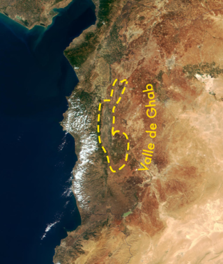
The Ghab Plain is a fertile depression lying mainly in the Al-Suqaylabiyah District in northwest Syria. The Orontes River, flowing north, enters the Plain near Muhradah, around 25 km north-west of Hama.

The Afrin River is a tributary of the Orontes River in Turkey and Syria. It rises in the Kartal Mountains in Gaziantep Province of Turkey, flows south through the city of Afrin in Syria, then reenters Turkey. It joins the Karasu at the site of the former Lake Amik, and its waters flow to the Orontes by a canal.

Kafr Zita is a town in northern Syria, administratively part of the Hama Governorate, located 30 kilometers north of Hama. Nearby localities include Kafr Nabudah and al-Habit to the northwest, Khan Shaykhun to the northeast, Mork to the east, Suran to the southeast, al-Lataminah, Halfaya and Mahardah to the south, Tremseh to the southwest and Kirnaz and Hayalin. According to the Syria Central Bureau of Statistics, Kafr Zita had a population of 17,052 in the 2004 census. It is also the center of a nahiyah ("subdistrict"), part of the Mhardeh District, that consists of seven localities with a combined population of 39,032 in 2004.
Halfaya is a town in northern Syria, administratively part of the Hama Governorate, located about 25 kilometers northwest of Hama. Nearby localities include Mahardah and Shaizar to the west, al-Lataminah and Kafr Zita to the north, Taybat al-Imam and Suran to the east, Khitab and Qamhana to the southeast, Tayzin to the south and Maarzaf to the southeast. According to the Syria Central Bureau of Statistics (CBS), Halfaya had a population of 21,180 in the 2004 census. It is the largest locality in the Mahardah Subdistrict, which contained 21 localities with a combined population of 80,165 in 2004.
Qarqur is a village in northern Syria, administratively part of the Hama Governorate, located northwest of Hama. It is situated in the al-Ghab plain, on the eastern bank of the Orontes River. Nearby localities include Jisr al-Shughur 6 kilometers to the north, Farikah to the northeast, Qastun to the southeast, al-Ziyarah 7 kilometers to the south, Sirmaniyah to the southwest and al-Najiyah to the northwest. According to the Syria Central Bureau of Statistics, Qarqur had a population of 2,356 in the 2004 census, making it the largest locality in the al-Ziyarah sub-district (nahiyah).

Al-Rastan Dam is an embankment dam on the Orontes River in the city of Al-Rastan, Homs Governorate, Syria. It was completed around 1975 with the primary purpose of water storage for irrigation. It was constructed by the Bulgarian firm Hydrostroy along with the Mouhardeh Dam, which is downstream and also on the Orontes.
Tell Sikkin is a Syrian village located in the Mahardah Subdistrict of the Mahardah District in Hama Governorate. According to the Syria Central Bureau of Statistics (CBS), Tell Sikkin had a population of 1,963 in the 2004 census.
Abu Ubaydah is a Syrian village located in the Mahardah Subdistrict of the Mahardah District in Hama Governorate. According to the Syria Central Bureau of Statistics (CBS), Abu Ubaydah had a population of 745 in the 2004 census.
Huwat is a Syrian village located in Mahardah Nahiyah in Mahardah District, Hama. According to the Syria Central Bureau of Statistics (CBS), Huwat had a population of 128 in the 2004 census.
Al-Judaydah is a Syrian village in the Mahardah Subdistrict of the Mahardah District in Hama Governorate. According to the Syria Central Bureau of Statistics (CBS), al-Judaydah had a population of 2,166 at the 2004 census.
Shir is a Syrian village located in the Mahardah Subdistrict of the Mahardah District in Hama Governorate. According to the Syria Central Bureau of Statistics (CBS), Shir had a population of 793 in the 2004 census.
Al-Arid is a Syrian hamlet located in the Mahardah Subdistrict of the Mahardah District in Hama Governorate. According to the Syria Central Bureau of Statistics (CBS), al-Arid had a population of 124 as of the 2004 census. Its inhabitants are predominantly Sunni Muslims.
Al-Tlul or Al-Tloul is a Syrian village located in Salqin Nahiyah in Harem District, Idlib. According to the Syria Central Bureau of Statistics (CBS), Al-Tlul had a population of 1703 in the 2004 census.

The Afrin Dam, officially 17 April Dam, also called Maydanki Dam, is an earth-filled water storage and hydroelectric power dam on the Afrin River in northwest Syria. It provides drinking water to almost 200,000 people, irrigates about 30,000 hectares of olives, fruit trees and agricultural crops, and supplies 25 MW of hydroelectric power. It is currently under the control of the Turkish Land Forces.
