Akbarpur is a town in Kanpur Dehat district in the state of Uttar Pradesh, India.
Brajrajnagar is a town and a municipality in Jharsuguda district in the state of Odisha, India. Popular legend says the town was named after Braj Mohan Birla after he set up Orient Paper Mills in 1936. It is a small sleepy town on rocky terrain, built on the banks of IB river, with temples mostly built by the Birlas. Later it became famous for MCL-owned coal mines after Orient Paper Mills of Birlas managed by dulichand Hanuman Prasad shah closed down in 1999.
Dighwara is a town and a Nagar Panchayat in the Saran district, state of Bihar, India. The name probably derives from 'Dirgh-dwar', literally "large gate", as Dighwara is claimed to be the entrance to the mythological city of king Daksha. During British Rule it was a Feudal Estate ruled by the Raghuvanshis.The town lies on the banks of Ganges River. A road bridge has been planned to be constructed over Ganges, between Dighwara and Danapur.

Lodhikheda is a town and a nagar parishad in Pandhurna district in the Indian state of Madhya Pradesh. It is famous for its oranges. More than 90 per cent of farmers produce oranges. Cotton is grown in large quantities in the local area.
Obra is a town, Tehsil, and Assembly constituency of the Indian state of Uttar Pradesh. It is located in the Sonebhadra district. It has been upgraded from the stature of Nagar Panchayat, and was previously a part of the Mirzapur District. Obra is located 137 km from Varanasi at the Banks of Renu & Sone River with population of 46,574 as per the 2011 India Census. State-owned UPRVUNL and UPJVUNL have a coal-fired thermal power plant and a hydroelectric power plant in Obra, respectively. The thermal and hydroelectric power industries are the major source of employment, either directly or indirectly. Obra is not very well connected by rail. The nearest railway station is Chopan, which is about 10 kilometers from Obra, and has connectivity to other major cities of India. Recreational places in Obra include Jawahar Bal Udayan, Ambedkar Stadium, Lord Shiva's temple, Sone river banks, and Parsoi and Kharatiya villages. Restructuring of government residential colony is ongoing as new power plants are being constructed.
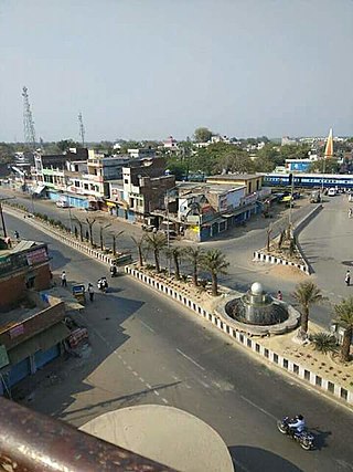
Rasra is a city and a municipal board in Ballia district in the Indian state of Uttar Pradesh. It is one among six tehsils that come under Ballia district, Rasra is also known as 'Chhoti Kashi' and 'Nath Nagri' due to the presence of Nath Baba mandir which is a well known religious spot. In past the production of sugar from rotten sugarcanes lead to the city being named 'Rasra' which is a portmanteau word made-up of two hindi words 'Ras' (रस) meaning juice and 'Sada/Sara' (सड़ा) meaning rotten. It has an important market for the nearby villages. Lounglatta is the famous sweet of Rasra. Dussehra is one of two very prominent festivals, here, alongside Chhath. Rasra has top schools of district. Rasra has second largest Durga Puja celebration in Uttar Pradesh after Ram Nagar, Varanasi. Rasra has a busy fish market, chicken market and mutton narket. It has also Sadar Bazaar, Station Road Market, Hospital Complex Market, Mission Road Market, Kali Maa ka chauraha. This place is known for all religious cultures, and has many temples, churches and mosques.
Reoti is a town and a nagar panchayat in Ballia district in the Indian state of Uttar Pradesh. Known for got freedom before 1947 As usual India had got freedom on 15 Aug 1947 but all across the India Reoti town got freedom in 1942.
Patiram is a village in Balurghat CD Block of Balurghat subdivision in Dakshin Dinajpur district in the state of West Bengal in India. Patiram is situated beside of Atreyee River. It is 11 km away from the district headquarters Balurghat.
Jajuara, also written Jajuar and Yajuar, is the largest village in the Muzaffarpur district of Bihar in India, and the second-largest village in Bihar.
Sihaul is a village with population of about 11,000 in the sub-district of Satar Kataiya, where it ranks as the third most populous village. The sub-district forms a part of Saharsa district in the state Bihar, India. The geographical area of the village is 9 km2 (3.5 sq mi) and it is the third biggest village by area in the sub-district. Population density of the village is 1287 persons per km2.
Bandhabahal is a small town in the Jharsuguda district in Odisha, India. It has a number of coal mines, which come under Mahanadi Coalfields Limited (M.C.L).
Sadiha is a village in Siwan district of Bihar, India. There is a nearby railway station named as sarhari railway station which comes under village sadiha. It is home to the Vishnudham Mandir temple and Kali Mandir Hanuman Mandir, Shiv Mandir and Chhath Ghat. Nearby markets include Patedha, Patedhi, Mora, Janta Bazar and Maharajganj. Durga Puja, Chhath Puja, Sarswati Puja, Holi, Diwali is there major festivals.
Patan Devi, also called Maa Patneshwari, is the oldest and one of the most sacred temples of Patna, Bihar. It is regarded as one of the 51 Siddha Shakti Pithas in India. According to Puranic legends, the 'right thigh' of the corpse of Devi Sati had fallen here when it was chopped off by Lord Vishnu with his 'Sudarshan Chakra'. The ancient temple, originally called Maa Sarvanand Kari Patneshwari, is believed to be the abode of the goddess Durga.

Shivpuri is a neighbourhood in Patna, capital of Bihar, India.
Itamati is a village located in Nayagarh district of Odisha, India. It is 6 km from Nayagarh Town. Itamati is known as the major business centre of Nayagarh, Also known as the second largest village of Odisha.
Jihuli is a village in the East Champaran district of Bihar, India.
Banior is a village and gram panchayat in Nalhati I Block in Rampurhat subdivision of Birbhum District in the Indian state of West Bengal. The other regional name of Banior is Banur।
Manik Chowk is a village in the Indian state of Bihar.

Birpur is a village in Vaishali district, Bihar which is situated at the river island called Raghopur Diyara Island. It is one of the largest village in Raghopur community block. People of this village are mostly dependent on agriculture. People in this area has long tradition of joining armed forces. Its population is approximately 20,000 and peoples of this village are living their life in peaceful manner. Most of the Villagers work outside and bring revenue to this place which helps flourish the local community and enhance purchasing power. Birpur comes under Raghopur community block and a police station is Jurawanpur. It is the second largest village in the Raghopur block in terms of area and population. its pin code is 844508. Education rate of this village is quite low around 33% overall. Higher education facility is not available in the village and also there are no major hospitals, only private clinics and some small hospitals. Thethi is the only language which people speaks. It is spread over in the area of 20 km.
Rajdham is a village in Gogari block of Khagaria district of Bihar State, India.

