
The St. Lawrence River is a large international river in the middle latitudes of North America connecting the Great Lakes to the North Atlantic Ocean. Its waters flow in a northeasterly direction from Lake Ontario to the Gulf of St. Lawrence, traversing Ontario and Quebec in Canada and New York in the United States. A section of the river demarcates the Canada–U.S. border.
Lawrence is a city located in Essex County, Massachusetts, United States, on the Merrimack River. At the 2020 census, the city had a population of 89,143. Surrounding communities include Methuen to the north, Andover to the southwest, and North Andover to the east. Lawrence and Salem were the county seats of Essex County, until the state abolished county government in 1999. Lawrence is part of the Merrimack Valley.

Belfast is a town in Allegany County, New York, United States. The town is in what is called the Southern Tier of the state. Its population was 1,656 at the 2020 census. It was named in 1825 after the city of Belfast, Ireland, because it had numerous residents of Scots-Irish ancestry from that area.
Lisbon is a town in St. Lawrence County, New York, United States. The population was 4,102 at the 2010 census.

Clearfield is a borough and the county seat of Clearfield County, Pennsylvania, United States. As of the 2020 census the population was 5,962 people, making it the second most populous community in Clearfield County, behind DuBois. The borough is part of the DuBois, PA Micropolitan Statistical Area, as well as the larger State College-DuBois, PA Combined Statistical Area. The settled area surrounding the borough consists of the nearby census-designated places of Hyde and Plymptonville, which combined with Clearfield have a population of approximately 8,237 people.
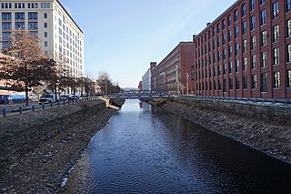
New Castle is a city in and the county seat of Lawrence County, Pennsylvania, United States. Located along the Shenango River at the mouth of Neshannock Creek, it is 43 miles (69 km) northwest of Pittsburgh near the Pennsylvania–Ohio border, approximately 17 miles (27 km) southeast of Youngstown, Ohio. As of the 2020 census, the city had a population of 21,926. The commercial center of a fertile agricultural region, New Castle is included in the northwestern part of the Pittsburgh metropolitan area.
Shenango Township is a township in Lawrence County, Pennsylvania, United States. The population was 7,133 at the 2020 census, a decline from the figure of 7,479 tabulated in 2010. Shenango Township is situated between the city of New Castle to the north and the borough of Ellwood City to the south.
Hammond is a town in St. Lawrence County, New York, United States. The population was 1,191 at the 2010 census. The name is derived from early land owner Abijah Hammond.

Beaver River is a tributary of the Ohio River in Western Pennsylvania. Approximately 21 mi (34 km) long, it flows through a historically important coal-producing region north of Pittsburgh. The river is formed in Lawrence County by the confluence of the Mahoning and Shenango rivers in the Mahoningtown neighborhood of New Castle. It flows generally south, past West Pittsburg and Homewood, then receives Connoquenessing Creek west of Ellwood City and flows past Beaver Falls and New Brighton. It joins the Ohio at Bridgewater and Rochester at the downstream end of a sharp bend in the Ohio approximately 20 mi (32 km) northwest of Pittsburgh. In the lower reaches near the Ohio River, the Beaver cuts through a gorge of underlying sandstone. The river is roughly parallel to the border with the state of Ohio, with both Interstate 376 and Pennsylvania Route 18 running parallel to the river itself.
U.S. Route 224 (US 224) is a spur of US 24 that runs through the states of Indiana, Ohio and Pennsylvania. It currently runs for 289 miles (465 km) from US 24 in Huntington, Indiana, east to US 422 Business and Pennsylvania Route 18 (PA 18) in New Castle, Pennsylvania. It goes through the cities of Canfield, Ohio, Akron, Ohio, and Findlay, Ohio. In Northeast Ohio, US 224 is located a short distance north of the Western Reserve's southern boundary.

The Mahoning River is a river in northeastern Ohio and a small portion of western Pennsylvania. Flowing primarily through several Ohio counties, it crosses the state line into Pennsylvania before joining with the Shenango River to form the Beaver River. The Mahoning River drops from 1,296 feet (395 m) at the headwaters near Winona to 761 feet (232 m) at the outfall near Mahoningtown, Pennsylvania. It is part of the Ohio River watershed. The name is said to derive from either the Lenape or Shawnee languages and mean "Deer Lick," as the area was once known for salt springs, but it's possible the name of the Mahoning and several other similarly named landmarks and places in western Pennsylvania could come from the Lenape, mënehokink (may-nuh-ho-keeng), meaning "place to get water."
Redstone Old Fort — or Redstone Fort or Fort Burd — on the Nemacolin Trail, was the name of the French and Indian War-era wooden fort built in 1759 by Pennsylvania militia colonel James Burd to guard the ancient Indian trail's river ford on a mound overlooking the eastern shore of the Monongahela River in what is now Fayette County, Pennsylvania, near, or on the banks of Dunlap's Creek at the confluence. The site is unlikely to be the same as an earlier fort the French document as Hangard dated to 1754 and which was confusedly, likely located on the nearby stream called Redstone Creek. Red sandstones predominate the deposited rock column of the entire region.
Newcastle usually refers to:
Pennsylvania Route 65 is a major 51-mile-long (82 km) state highway located in western Pennsylvania, United States. The route, traveling north–south from the Interstate 279/U.S. Route 19 Truck concurrency in Pittsburgh north to the PA 108/PA 168 concurrency in New Castle, connects downtown Pittsburgh to the northwestern portion of the Pittsburgh Metropolitan Area. PA 65 is similar in its purpose to PA 18 and PA 51, both of which run parallel to PA 65 at one point or another; however, the three routes pass through different cities for most of their respective alignments.

Pennsylvania Route 18 is a major north–south highway in Western Pennsylvania whose southern terminus is at West Virginia Route 69 at the state line in Greene County near the village of Garrison, while the northern terminus is at PA 5 in Lake City. At a length of 205 miles (330 km), PA 18 is the only state route in Pennsylvania — north–south or east–west — to traverse the entire state. It also has the distinction of being the longest state route in Pennsylvania.

The Great Lakes Seaway Trail, formerly named and commonly known as the Seaway Trail, is a 518-mile (834 km) National Scenic Byway in the northeastern United States, mostly contained in New York but with a small segment in Pennsylvania. The trail consists of a series of designated roads and highways that travel along the Saint Lawrence Seaway—specifically, Lake Erie, the Niagara River, Lake Ontario, and the Saint Lawrence River. It begins at the Ohio state line in rural Erie County, Pennsylvania, and travels through several cities and villages before ending at the Seaway International Bridge northeast of the village of Massena in St. Lawrence County, New York. It is maintained by the non-profit Seaway Trail, Inc.

New Castle Area Transit Authority is a public transportation service located in Lawrence County, Pennsylvania. It provides inter-city bus and paratransit service to select communities within the county. Because the region is located within the metropolitan area of Pittsburgh, service is provided to the downtown area.

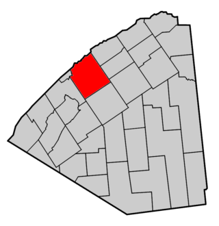
Lawrence County is a county in the Commonwealth of Pennsylvania. As of the 2020 census, the population was 86,070. The county seat and largest city is New Castle.
The North Western Railroad was a shortline railroad located in the western part of the U.S. state of Pennsylvania in the United States. It organized in 1853, and was purchased by the Western Pennsylvania Railroad in 1859 after completing only a portion of its route.
The Stavich Bike Trail is a National Recreation Trail located in Mahoning County, Ohio and Lawrence County, Pennsylvania. The rail trail is 9.9 miles long and goes from Lowellville to Union Township in Lawrence County, traveling directly through Lowellville. It was constructed on the former Penn-Ohio Electric System trolley line along the Mahoning River in 1983, adjacent to the CSX New Castle Subdivision tracks. Considered an early example of rail-trails, its 1983 construction was dependent on a donation from the Stavich family, who ran many aluminum mills in the Youngstown area.


