Mahuaon

Last updated

Mahuaon
Mahuāon
Village
Behea block map.png
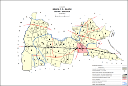
Map of Mahuaon (#185) in Behea block
India Bihar location map.svg
Red pog.svg
Mahuaon
Location in Bihar, India
India location map.svg
Red pog.svg
Mahuaon
Mahuaon (India)
Coordinates: 25°31′53″N84°23′53″E / 25.5314°N 84.39812°E / 25.5314; 84.39812 [1]
CountryIndia
State Bihar
District Bhojpur
Area
[2]
  Total0.291 km2 (0.112 sq mi)
Elevation
[1]
69 m (226 ft)
Population
 (2011)
  Total3,093 [2]
Languages
  Official Bhojpuri, Hindi
Time zone UTC+5:30 (IST)

Mahuaon is a village in the southern part of Bihiya block, in Bhojpur district, Bihar, India. As of 2011, its population was 3,093, in 457 households. [2]

Related Research Articles

<span class="mw-page-title-main">Arrah</span> City in Bihar, India

Arrah is a city and a municipal corporation in Bhojpur district in the Indian state of Bihar. It is the headquarters of Bhojpur district, located near the confluence of the Ganges and Sone rivers, some 24 mi (39 km) from Danapur and 36 mi (58 km) from Patna.

<span class="mw-page-title-main">Bhojpur district, India</span> District of Bihar in India

Bhojpur district is one of the thirty-eight districts of the Indian state of Bihar. Arrah town is the administrative headquarters of this district. Bhojpur district came into existence in 1972. Earlier it was the part of Shahabad district. This district is named "Bhojpur" after great Parmara King Bhoja as most early settlers were Rajput rulers of Parmara dynasty then called as Ujjainiya.

<span class="mw-page-title-main">Barhara</span> Village in Bihar, India

Barhara, also spelled Badahar, Barahara, or Barahra, is a village and corresponding community development block in Bhojpur District of Bihar, India. It is situated on the bank of the river Ganges. By the time of July–August most of the villages under this block are affected by deluge. As of 2011, its population was 6,889, in 927 households, while the total block population was 240,636, in 35,185 households.

<span class="mw-page-title-main">Sinha, Barhara</span> Village in Bihar, India

Sinha is a village in Barhara block of Bhojpur district in Bihar, India. As of 2011, its population was 13,186, in 1,953 households.

<span class="mw-page-title-main">Milki, Barhara</span> Village in Bihar, India

Milki is a village in Barhara block of Bhojpur district in Bihar, India. As of 2011, its population was 1,748, in 218 households.

<span class="mw-page-title-main">Jokahri, Bhojpur</span> Village in Bihar, India

Jokahri is a village in Barhara block of Bhojpur district in Bihar, India. As of 2011, its population was 1,362, in 260 households.

<span class="mw-page-title-main">Parasrampur, Bhojpur</span> Village in Bihar, India

Parasrampur is a village in Barhara block of Bhojpur district in Bihar, India. As of 2011, its population was 1,548, in 185 households.

<span class="mw-page-title-main">Bakhorapur, Bhojpur</span> Village in Bihar, India

Bakhorapur is a village in Barhara block of Bhojpur district in Bihar, India. As of 2011, its population was 4,903, in 682 households.

<span class="mw-page-title-main">Paiga, Bhojpur</span> Village in Bihar, India

Paiga is a village in Barhara block of Bhojpur district in Bihar, India. As of 2011, its population was 3,456, in 538 households.

<span class="mw-page-title-main">Rampur, Barhara</span> Village in Bihar, India

Rampur is a village in Barhara block of Bhojpur district in Bihar, India. As of 2011, its population was 1,944, in 270 households.

<span class="mw-page-title-main">Agarpura, Bhojpur</span> Village in Bihar, India

Agarpura is a village in Barhara block of Bhojpur district in Bihar, India. As of 2011, its population was 738, in 101 households.

<span class="mw-page-title-main">Babura, Bhojpur</span> Village in Bihar, India

Babura is a large village in Barhara block of Bhojpur district in Bihar, India. As of 2011, its population was 28,412, in 4,291 households. That year, it was the most populous village in Bhojpur district.

<span class="mw-page-title-main">Phulai, Bhojpur</span> Village in Bihar, India

Phulai is a village in the southern part of Bihiya block in Bhojpur district, Bihar, India. As of 2011, its population was 955, in 135 households.

<span class="mw-page-title-main">Chakwath</span> Village in Bihar, India

Chakwath is a village in Bihiya block of Bhojpur district, Bihar, India. As of 2011, its population was 4,964, in 760 households.

<span class="mw-page-title-main">Khakhu Bandh</span> Village in Bihar, India

Khakhu Bandh is a small village in the southern part of Bihiya block in Bhojpur district, Bihar, India. As of 2011, its population was 426, in 56 households.

<span class="mw-page-title-main">Osain, Bhojpur</span> Village in Bihar, India

Osain is a village in the west-central part of Bihiya block in Bhojpur district, Bihar, India. As of 2011, its population was 6,308, in 966 households.

<span class="mw-page-title-main">Andar, Bhojpur</span> Village in Bihar, India

Andar is a village in Bihiya block of Bhojpur district in Bihar, India. As of 2011, its population was 1,790, in 265 households.

<span class="mw-page-title-main">Asodhar, Bhojpur</span> Village in Bihar, India

Asodhar is a village in Jagdishpur block of Bhojpur district in Bihar, India. As of 2011, its population was 861, in 111 households.

<span class="mw-page-title-main">Aer, Bhojpur</span> Village in Bihar, India

Aer is a large village in the southeastern part of Jagdishpur block in Bhojpur district, Bihar, India. As of 2011, its population was 13,305, in 2,127 households.

<span class="mw-page-title-main">Garaiyan, Bhojpur</span> Village in Bihar, India

Garaiyan, also spelled Gareyan or Gariyan, is a small village in Arrah block of Bhojpur district, Bihar, India. As of 2011, its population was 2, in 1 household, making it the least populous village in Bhojpur district.

References

  1. 1 2 "Geonames.org. Mahuāon" . Retrieved 18 August 2020.
  2. 1 2 3 "Census of India 2011: Bihar District Census Handbook - Bhojpur, Part A (Village and Town Directory)". Census 2011 India. pp. 436–475. Retrieved 18 August 2020.