Main South

Last updated
Worcester Corset Company Factory on Wyman Street. Worcester Corset Factory.jpg
Worcester Corset Company Factory on Wyman Street.
Jonas Clark Hall, built in 1887, is the main academic building at Clark University. JonasClarkBuilding.JPG
Jonas Clark Hall, built in 1887, is the main academic building at Clark University.
The Daniel Hunt Three-Decker, located at 9 Wyman Street, was built in 1890. 9WymanWorcesterFront.JPG
The Daniel Hunt Three-Decker, located at 9 Wyman Street, was built in 1890.

Main South (or South Main) is a neighborhood in southern Worcester, Massachusetts. The area's eponymous feature is Main Street, the central roadway of the city. Main South experienced rapid economic development from the 1890s until the 1950s.

Contents

History

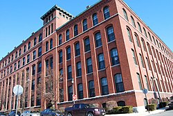
The history of the Main South neighborhood began when, in the 1840s, congressman Eli Thayer, a prominent abolitionist, bought land in southern Worcester in anticipation of rapid economic development. Thayer sold the land without extensive development in order to finance the New England Emigrant Aid Company, which sent abolitionist settlers to Kansas Territory in order to ensure that it would not become a slave state. Development began in the 1850s. In the 1880s, industrialist Jonas Gilman Clark bought land and founded Clark University in 1887. [1] The Main South area has a history as a rough neighborhood, known for prostitution and hard drugs starting in the 1970s and that impression has stuck with the area, despite the fact that the Worcester Police Department has done a great deal to reduce the drug trade, and there has been some fairly successful urban renewal projects, particularly involving Clark University.

Prominent locations

Related Research Articles

Worcester County, Massachusetts County in Massachusetts

Worcester County is a county located in the U.S. state of Massachusetts. As of the 2010 census, the population was 798,552, making it the second-most populous county in Massachusetts while also being the largest in area. The estimated population as of July 1, 2019 is 830,622. The largest city and traditional county seat is the city of Worcester.

South End, Boston United States historic place

The South End is a neighborhood of Boston, Massachusetts. It is bordered by Back Bay, Chinatown, and Roxbury. It is distinguished from other neighborhoods by its Victorian style houses and the many parks in and around the area. The South End is the largest intact Victorian row house district in the country, as it is made up of over 300 acres. Eleven residential parks are contained within the South End. In 1973, the South End was listed in the National Register of Historic Places. Much of the South End was originally marshlands in Boston's South Bay. After being filled in, construction of the neighborhood began in 1849.

Brighton, Boston Neighborhood of Boston in Suffolk, Massachusetts, United States

Brighton is a former town and current neighborhood of Boston, Massachusetts, United States, located in the northwestern corner of the city. It is named after the town of Brighton in the English city of Brighton and Hove. Initially Brighton was part of Cambridge, and known as "Little Cambridge". Brighton separated from Cambridge in 1807 after a bridge dispute, and was annexed to Boston in 1874. For much of its early history, it was a rural town with a significant commercial center at its eastern end.

West End, Atlanta United States historic place

West End is a historic neighborhood of Atlanta, one of the oldest outside Downtown Atlanta, and is listed on the National Register of Historic Places. West End residents are primarily (86%) African American and the neighborhood contains several prominent African American cultural institutions, in addition to being adjacent to the Atlanta University Center complex of HBCUs. West End is located southwest of Castleberry Hill, east of Westview, west of Adair Park Historic District, and just north of Oakland City. Architectural styles within the district include Craftsman Bungalow, Queen Anne, Stick style, Folk Victorian, Colonial Revival, American Foursquare and Neoclassical Revival.

Allston–Brighton is a set of two interlocking neighborhoods, Allston and Brighton, both part of the city of Boston, Massachusetts.

South Medford is the southern neighborhood of Medford, Massachusetts.

The University District, is a 2.8-square-mile (7.3 km2) area located 2 miles (3.2 km) north of Downtown Columbus, Ohio that is home to the main campus of The Ohio State University, the Battelle Institute, and Wexner Medical Center. It is generally accepted as the area bounded to the north by Clintonville at Glen Echo Ravine; to the south by the Short North at 5th Avenue; to the west by the Olentangy River and to east by the Conrail railroad tracks. Points of interest include, but are not limited to, the Ohio Stadium and Old North Columbus. The district is Columbus' most densely populated area and contains more than 650 businesses, human service agencies, churches, and schools. University District businesses include boutiques, mixed retail, several tattoo studios, the Gateway Film Center, the CampusParc Customer Care Center, and a diverse range of restaurants and bars.

Uxbridge Free Public Library

The Uxbridge Free Public Library is the public library in Uxbridge, Massachusetts. It opened in 1875.

College Hill, Providence, Rhode Island Neighborhood of Providence in Rhode Island, United States

College Hill is a historic neighborhood of Providence, Rhode Island, and one of six neighborhoods comprising the city's East Side. It is roughly bounded by South and North Main Street to the west, Power Street to the south, Governor Street and Arlington Avenue to the east and Olney Street to the north. The neighborhood's primary commercial area extends along Thayer Street, a strip frequented by students in the Providence area.

Old Fourth Ward Neighborhoods of Atlanta in Fulton County, Georgia, United States

The Old Fourth Ward, often abbreviated O4W, is an intown neighborhood on the eastside of Atlanta, Georgia, United States. The neighborhood is best known as the location of the Martin Luther King Jr. historic site.

South Congress Neighborhood in Austin, Texas, United States

South Congress is a neighborhood located on South Congress Avenue in Austin, Texas, United States. It is also a nationally known shopping and cultural district known for its many eclectic small retailers, restaurants, music and art venues and, more recently, food trucks.

Hope Cemetery (Worcester, Massachusetts) United States historic place

Hope Cemetery is an historic rural cemetery at 119 Webster Street in Worcester, Massachusetts. Established in 1854, it was the city's sixth public cemetery, and is the burial site of remains originally interred at its first five cemeteries. Its landscaping and funerary art are examplars of the rural cemetery movement, and the cemetery was listed on the National Register of Historic Places in 1997. The cemetery occupies 168 acres (68 ha).

South Los Angeles Regions of Los Angeles County in California, United States

South Los Angeles, formerly South Central Los Angeles, is an area in southern Los Angeles County, California, lying mostly within the city limits of Los Angeles, south of downtown. It is "defined on Los Angeles city maps as a 16-square-mile rectangle with two prongs at the south end.” In 2003, the Los Angeles City Council renamed this area "South Los Angeles".

Wellington-Harrington

Wellington-Harrington, also known as Area 3, is a neighborhood in Cambridge, Massachusetts. Overlapping with Inman Square and Kendall Square, it is bounded by Hampshire Street and Broadway on the southwest, the Grand Junction railroad tracks on the east, and the Somerville town line on the north.

Norma Triangle is a residential neighborhood in West Hollywood, California. It encompasses the area bound by Doheny Drive and Beverly Hills on the west, Sunset Boulevard and Holloway Drive on the north, and Santa Monica Boulevard on the south. The small district has the shape of a right triangle.

University Park (Worcester, Massachusetts)

University Park, also called Crystal Park, is a public park in the Main South neighborhood of Worcester, Massachusetts. The 13-acre (53,000 m2) park was acquired by the city from 1887 to 1889, costing nearly 62,000 dollars. It is located across Main Street from Clark University, thus the name. University Park Campus School, a local nearby public high school founded with help from Clark, is named after the park.

North Street (Boston)

North Street in the North End of Boston, Massachusetts extends from Congress Street to Commercial Street. It runs past Dock Square, Faneuil Hall, Quincy Market, the Rose Kennedy Greenway, and North Square. It was first named in 1852, and consists of segments of streets formerly named Ann, Fish, Ship, Drawbridge, and Conduit Streets.

Hadwen Arboretum

The Hadwen Arboretum is a 26-acre (11 ha) forest located in the Columbus Park neighborhood of Worcester, Massachusetts. The front entrance is situated at the corner of May and Lovell St. It contains many heritage trees that were originally planted by its caretaker Obadiah Hadwen. The property is owned and maintained by nearby Clark University.

Beacon Park Yard Former rail freight yard in Boston planned for redevelopment

Beacon Park Yard was a CSX Transportation rail yard in Allston, Boston, now owned by Harvard University. The yard opened in 1890 on the site of a former trotting park, from which it took its name. It was closed in 2013 following the relocation of the yard's container operations to Worcester, Massachusetts and opening of a transload facility in Westborough, Massachusetts. Plans for the yard include relocation of the Massachusetts Turnpike Allston exit, construction of a new MBTA commuter rail station and layover yard, and a major real estate development.

Rural Cemetery (Worcester, Massachusetts)

Rural Cemetery is located on 180 Grove Street in Worcester, Massachusetts. More than 13,000 people are buried at the cemetery, including congressmen, mayors, governors, and professional people.

References

Coordinates: 42°15′N71°49′W / 42.25°N 71.82°W / 42.25; -71.82