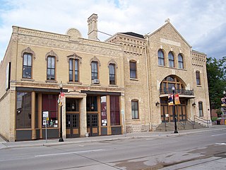
Main Street Historic District | |
Location | Main and Appleton Sts., Menomonee Falls, Wisconsin |
---|---|
Coordinates | 43°10′46″N88°06′47″W / 43.17944°N 88.11306°W |
Area | 6 acres (2.4 ha) |
MPS | Menomonee Falls MRA |
NRHP reference No. | 88001629 [1] |
Added to NRHP | September 21, 1988 |
The Main Street Historic District is a cluster of historic buildings around the intersection of Main Street and Appleton Avenue in Menomonee Falls, Wisconsin. It was added to the National Register of Historic Places in 1988. [2]
Menomonee Falls was established in 1836 near a series of rapids of the Menomonee River. The river was dammed to power sawmills and wheat mills, and homes and other businesses grew around the mills. The surrounding lands provided timber, limestone to be quarried, and farmlands. The historic district coincides roughly with the old "Four Corners" area of Menomonee Fall, including the industrial area along the river and business district where Main Street meets Appleton Avenue. [3]
Here are some surviving historic buildings in the district, roughly in the order built:
Menomonee Falls is a village in Waukesha County, Wisconsin, United States, and is part of the Greater Milwaukee area. The population was 38,527 at the 2020 census, making it the most populous village in Wisconsin. It is the fourth largest community in Waukesha County.
The Historic Third Ward is a historic warehouse district located in downtown Milwaukee, Wisconsin. This Milwaukee neighborhood is listed on the National Register of Historic Places. Today, the Third Ward is home to over 450 businesses and maintains a strong position within the retail and professional service community in Milwaukee as a showcase of a mixed-use district. The neighborhood's renaissance is anchored by many specialty shops, restaurants, art galleries and theatre groups, creative businesses and condos. It is home to the Milwaukee Institute of Art and Design (MIAD), and the Broadway Theatre Center. The Ward is adjacent to the Henry Maier Festival Park, home to Summerfest. The neighborhood is bounded by the Milwaukee River to the west and south, E. Clybourn Street to the north, and Lake Michigan to the east.
Bay View is a neighborhood in Milwaukee, Wisconsin, United States, North America on the shores of Lake Michigan, south of the downtown area and north of the City of St. Francis. Bay View existed as an independent village for eight years, from 1879 to 1887.
The neighborhoods of Milwaukee include a number of areas in southeastern Wisconsin within the state's largest city at nearly 600,000 residents.
The Main Street Historic District in Fort Atkinson, Wisconsin, United States, was placed on the National Register of Historic Places in 1984. The district is composed of 51 buildings on or within a block of Main Street.
The Merchants Avenue Historic District in a residential neighborhood southeast of the downtown in Fort Atkinson, Wisconsin, composed of 33 mostly large homes on large lots within six city blocks around Merchants Avenue. It was placed on the United States National Register of Historic Places in 1986.
Washington Avenue Historic District is the historic center of Cedarburg, Wisconsin, the location of the early industry and commerce that was key to the community's development. The historic district was listed on the National Register of Historic Places (NRHP) in 1986.
William Waters (1843–1917) was an American architect who designed numerous buildings in Wisconsin that eventually were listed on the National Register of Historic Places. He was responsible for designing much of historic Oshkosh, Wisconsin. He was also responsible for designing the Wisconsin building for the Columbian Exposition. Waters died in 1917 and is buried at Riverside Cemetery in Oshkosh. After his death, Oshkosh honored him by naming the intersection of Washington Avenue and State Street as the "William Waters Plaza".
Neillsville Downtown Historic District is a section of the historic old downtown of Neillsville, Wisconsin, with buildings as old as 1872. It was added to the National Register of Historic Places in 2000.
The Iron County MRA is a Multiple Resource Area addition to the National Register of Historic Places, which includes 72 separate structures and historic districts within Iron County, Michigan, United States of America. These properties were identified and placed on the Register in 1983, with the exception of one property that was placed on the Register in 1993.
The Stoughton Main Street Commercial Historic District is a collection of 36 surviving historic business structures in the old downtown of Stoughton, Wisconsin, United States. It was added to the National Register of Historic Places in 1982.
The Church Street Historic District is a one-block neighborhood of historic homes built from about 1857 to 1920. It was added to the National Register of Historic Places in 1989.
The Florida and Third Industrial Historic District is a group of multistory industrial lofts built from 1891 to 1928 near the Soo Line rail-yard in Milwaukee, Wisconsin, United States. It was added to the National Register of Historic Places in 2008.
The Southside Historic District is a large, prestigious historic neighborhood in Racine, Wisconsin, including over 500 contributing structures in various architectural styles. It was added to the National Register of Historic Places in 1977.
The Courthouse Hill Historic District is a 30-block area on the east side of Janesville, Wisconsin, containing many historic structures built from the mid-1800s to the early 1900s in various styles, including homes of many of Janesville's influential leaders from that period. The district was added to the National Register of Historic Places in 1986.
The South Main Street Historic District is a surviving collection of eleven commercial buildings built from 1877 to 1915 in the old downtown of Oregon, Wisconsin, plus the WWI memorial. It was added to the State and the National Register of Historic Places in 2000.
The Old World Third Street Historic District is the last relatively intact part of the original German retail district in Milwaukee, Wisconsin's Kilbourntown plat, containing examples of various styles of Victorian commercial architecture going back to 1855. It was listed on the National Register of Historic Places in 1987 and on the State Register of Historic Places in 1989.
The Walker's Point Historic District is a mixed working-class neighborhood of homes, stores, churches and factories in Milwaukee, Wisconsin, with surviving buildings as old as 1849, including remnants of the Philip Best Brewery and the Pfister and Vogel Tannery. In 1978 it was added to the National Register of Historic Places. The NRHP nomination points out that Walker's Point was "the only part of Milwaukee's three original Settlements to reach the last quarter of the Twentieth Century with its Nineteenth and early-Twentieth Century fabric still largely intact," and ventures that "For something similar, one would have to travel to Cleveland or St. Louis if, indeed, so cohesive and broad a grouping of...structures still exists even in those cities."
The Columbia Historic District is a neighborhood in Cedarburg, Wisconsin, that is listed on the National Register of Historic Places. At the time the district was listed on the register, its contributing properties included 128 historic homes, one church, and eighty-seven historic outbuildings, including garages and barns, all constructed between 1844 and 1938. The district also contained several dozen buildings that do not contribute to the historic district, including modern homes from the post-war era as well as modern garages and other additions to historic properties.
The West Hill Residential Historic District is a historic neighborhood on a bluff above the Chippewa River west of downtown Chippewa Falls, Wisconsin. It includes 163 contributing properties in a variety of styles, ranging from mansions of lumber executives built in the 1870s to ranch houses of the 1950s. In 2021 the district was placed on the National Register of Historic Places.