
The Sandy River and Rangeley Lakes Railroad (SR&RL) was a 2 ft narrow gauge common carrier railroad that operated approximately 112 miles (180 km) of track in Franklin County, Maine. The former equipment from the SR&RL continues to operate in the present day on a revived, short segment of the railway in Phillips, Maine.
The Western Lakes and Mountains region spans most of Maine's western border with New Hampshire. A small part of the scenic White Mountain National Forest is located in this area. The region consists of Oxford County, Androscoggin County, Franklin County, as well as northern York and interior Cumberland counties. The largest cities in the region are Lewiston and Auburn. Notable towns include Bethel, Bridgton, Oxford, Rangeley, and Rumford. Many of the state's highest peaks are located in the region, although the highest, Mount Katahdin, is not.

Merrymeeting Bayis a large freshwater tidal bay located in the U.S. state of Maine. Merrymeeting Bay's unusual geography defies common landform terms. It is not what is usually meant by the word bay. It is somewhat like an estuary but it has fresh water with very little salt. Geologically it is described as an "inland delta" and biologically as "tidal riverine."
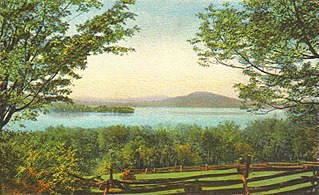
Rangeley Lake, located in Franklin County, Maine, United States, is fed by several streams. Its waters flow out from the lake's northwestern corner via the short Rangeley River into Mooselookmeguntic Lake, then Upper and Lower Richardson Lakes, Umbagog Lake and ultimately into the Androscoggin River, Merrymeeting Bay, the lower Kennebec River, the Gulf of Maine and the Atlantic Ocean.

Mooselookmeguntic Lake is located in Franklin County and Oxford County, Maine, in the United States. It is part of the Androscoggin River watershed. It is located in the western part of Maine, near the border with the state of New Hampshire and the Canadian province of Quebec. The lake is just a few miles from the Appalachian Trail.
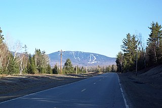
Saddleback Mountain is a mountain located in Sandy River Plantation, Franklin County, Maine, near the resort town of Rangeley. Saddleback is one of the highest mountains in the State of Maine, and one of the fourteen with more than 2,000 ft (610 m) of topographic prominence. The mountain is the site of Saddleback ski resort.

Fort Halifax is a former British colonial outpost on the banks of the Sebasticook River, just above its mouth at the Kennebec River, in Winslow, Maine. Originally built as a wooden palisaded fort in 1754, during the French and Indian War, only a single blockhouse survives. The oldest blockhouse in the United States, it is preserved as Fort Halifax State Historic Site, and is open to the public in the warmer months. The fort guarded Wabanaki canoe routes that reached to the St. Lawrence and Penobscot Valleys via the Chaudière-Kennebec and Sebasticook-Souadabscook rivers. The blockhouse was declared a National Historic Landmark and added to the National Register of Historic Places in 1968.

Grafton Notch is a notch, or mountain pass, located in Oxford County, Maine. The notch demarks the northeastern end of the Mahoosuc Range, and thus of the White Mountains. Maine State Route 26 passes through the notch.

The Sebasticook River is a 76-mile-long (122 km) river in the central part of Maine, in the United States. From its source in Dexter, the upper "Main Stream" section flows generally west and south 30 miles (48 km) to Great Moose Lake. From the outlet of the lake in Hartland, the Sebasticook flows 41 miles (66 km) south to the Kennebec River in Winslow.

The city of Portland, Maine, is the hub city of a metropolitan area in southern Maine. The region is commonly known as Greater Portland or the Portland metropolitan area. For statistical purposes, the U.S. federal government defines three different representations of the Portland metropolitan area. The Portland–South Portland, Maine, metropolitan statistical area is a region consisting of three counties in Maine, anchored by the city of Portland and the smaller city of South Portland. As of the 2020 census, the MSA had a population of 551,740. A larger combined statistical area (CSA), the Portland–Lewiston–South Portland combined statistical area, is defined as the combination of this metropolitan statistical area (MSA) with the adjacent Lewiston–Auburn MSA. The CSA comprises four counties in southern Maine. The Portland–South Portland metropolitan New England city and town area is defined on the basis of cities and towns rather than entire counties. It consists of most of Cumberland and York counties plus the town of Durham in Androscoggin County. The Greater Portland area has emerged as an important center for the creative economy, which is also bringing gentrification.
The Maine flood of 1987 was a pair of spring storms in March and April 1987, which combined with snow-melt, resulted in heavy flooding in Maine, New Hampshire and Massachusetts.

The Maine Central Railroad Company main line extended from Portland, Maine, east to the Canada–US border with New Brunswick at the Saint Croix–Vanceboro Railway Bridge. It is the transportation artery linking Maine cities to the national railway network. Sections of the main line had been built by predecessor railroads consolidated as the Maine Central in 1862 and extended to the Canada–US border in 1882. Through the early 20th century, the main line was double track from South Portland to Royal Junction, where it split into a lower road through Brunswick and Augusta and a back road through Lewiston which converged at Waterville into single track to Bangor and points east. Westbound trains typically used the lower road with lighter grades, while eastbound trains of empty cars used the back road. This historical description does not include changes following purchase of the Maine Central Railroad by Guilford Transportation Industries in 1981 and subsequent operation as part of Pan Am Railways.

Rangeley Lake State Park is a public recreation area occupying 870 acres (350 ha) on the southern shore of Rangeley Lake in Franklin County, Maine. The state park is located partly in the town of Rangeley and partly in Rangeley Plantation. It is managed by the Maine Department of Agriculture, Conservation and Forestry.

Evans Notch is a mountain pass located in the White Mountains in Maine, United States, about 1 mile (1.6 km) east of the New Hampshire border. It is the easternmost notch through the White Mountains. To the south, the notch is drained by the Cold River, which leads via the Charles River to the Saco River, which in turn flows into the Gulf of Maine east of Saco and Biddeford. The Mad River is a small mountain stream that joins the Cold River from the west about 2 miles (3 km) south of the height of land, after dropping over Mad River Falls. The notch is drained to the north by Evans Brook, a tributary of the Wild River, which flows north to the Androscoggin River. The Androscoggin leads east and south to the Kennebec River at Merrymeeting Bay north of Bath, Maine.
The Brunswick-Topsham Land Trust is a volunteer-run conservation group based in Brunswick, Maine, United States. Established in 1985 and funded by its members, it owns many preserves and trail networks, and has assisted in the creation of town-owned parks and preserves. The trust, one of eighty land trusts in Maine, covers the towns of Brunswick, Topsham and Bowdoin.