Related Research Articles

Ragged Island Wildlife Management Area, also known as Ragged Island Wildlife Refuge, is a 1,537-acre (6.22 km2) Wildlife Management Area (WMA) in Isle of Wight County, Virginia. Within a few miles of one of Virginia’s busiest and most populated regions is the Ragged Island Wildlife Management Area, a largely unspoiled area of marshland and scattered woody hummocks. It includes unspoiled brackish marsh and small pine islands adjacent the south bank of the James River. The area is dominated by vegetation such as marsh mallow, smartweed, saltmarsh cordgrass, and black needlerush, with loblolly pine as the most common tree species. Impenetrable areas of wax myrtle and greenbriar are also found on the property. The area is known in particular for its wide range of waterfowl.

Burrage Pond Wildlife Management Area is located in the towns of Hanson and Halifax in Massachusetts, USA. The area is composed of 1,625 acres (6.58 km2) of open land for public use, including hiking, biking, and birding. Hunting is permitted except on Sundays. BPWMA is made up mainly of swampy lands, old cranberry bogs, and cedar forest. It is managed by the Massachusetts Department of Fisheries and Wildlife.

Chester F. Phelps Wildlife Management Area is a 4,539-acre (18.37 km2) Wildlife Management Area located in Fauquier and Culpeper counties, Virginia. It contains over 1,000 acres (4 km2) of open land previously used for agriculture; additional open areas may be found within the forests on the property. Most of the terrain is rolling, low, and shallow; the steepest land can be seen near the Rappahannock River, which forms a large part of the property's western border. A number of small streams cross the land, and a three-acre (12,000 m2) pond is located near its center. The forests on the property contain both pine and hardwood.

Horsepen Lake Wildlife Management Area is a 2,910-acre (11.8 km2) Wildlife Management Area in Buckingham County, Virginia. It sits at about 500 feet (150 m) above sea level on the southeastern part of the drainage area of the Slate River. The area includes small streams, beaver ponds, and forests of pine, oak, and hickory. The 18-acre (7.3 ha) Horsepen Lake is also located on the property.
James River Wildlife Management Area is a 1,213-acre (4.91 km2) Wildlife Management Area (WMA) in Nelson County, Virginia, near the town of Wingina. It consists of hilly woodland and relatively level bottomland along slightly more than one mile (1.6 km) of the James River. Elevations at the area range from 350 to 500 feet above sea level.
Powhatan Wildlife Management Area is a 4,462-acre (18.06 km2) Wildlife Management Area (WMA) in Powhatan County, Virginia. Consisting primarily of former farmland, much of the area is currently covered by open fields; these combine with mature and new forest growth to provide habitat for a diverse array of wildlife. The property is divided by Route 60 and contains one interior parcel of privately owned land. The elevation of the property is between 200 and 350 feet above sea level.
Rapidan Wildlife Management Area is a 10,326-acre (41.79 km2) Wildlife Management Area (WMA) in Madison and Greene counties, Virginia. It is composed of eight separate tracts of land along the eastern slope of the Blue Ridge Mountains; four of these adjoin Shenandoah National Park, and combined they share 25 miles (40 km) of boundary.
Saxis Wildlife Management Area is a 5,578-acre (22.57 km2) Wildlife Management Area (WMA) in Accomack County, Virginia. Predominantly tidal marshland, it is divided into three tracts, all located on peninsulas bordering on brackish waters such as Beasley Bay, Pocomoke Sound, and Messongo Creek. Several smaller freshwater creeks are also found on the property. Portions of the area farthest inland are occupied by hummocks. The property is maintained by the Virginia Department of Game and Inland Fisheries mostly in its natural state, with little in the way of human management or development.
Turkeycock Wildlife Management Area is a 2,679-acre (10.84 km2) Wildlife Management Area (WMA) along the ridge of Turkeycock Mountain northeast of Martinsville, Virginia. It straddles the border between Franklin and Henry counties. The area is primarily forest, with several open areas for wildlife located around the property. The lowest elevation is 1,100 feet (340 m) above sea level, while the highest is over 1,700 feet (520 m). A number of small streams drain the land, and a pond is located near its southwestern corner. Most wildlife management in the area has been limited to improving timber quality through the sale of wood.
White Oak Mountain Wildlife Management Area is a 2,748-acre (11.12 km2) Wildlife Management Area (WMA) in Pittsylvania County, Virginia, United States. More a plateau than a mountain, the area's topography contains elevations ranging from approximately 550 to 900 feet above sea level. The property is nearly two-thirds forest, with timber types including pines and various examples of hardwoods, such as several species of oak. Forest management, annual and perennial plantings, and controlled burns are used to enhance wildlife habitat within the area. The land is dotted with ponds ranging in size from one to five acres, and its northwest boundary is formed by the Banister River.

G. Richard Thompson Wildlife Management Area, one of the richest botanical areas of Virginia's Blue Ridge Mountains, is a 4,000-acre (16 km2) Wildlife Management Area (WMA) located primarily in Fauquier County, Virginia, with small encroachments into both Warren and Clarke counties.

Scarborough Marsh is a 3,200-acre saltwater marsh owned by the state of Maine and managed by the state's Department of Inland Fisheries and Wildlife as a wildlife management area. It is situated in southern Maine, in the town of Scarborough, in Cumberland County.
Sunkhaze Meadows National Wildlife Refuge is located in the Town of Milford, Penobscot County, Maine, approximately fourteen miles north of Bangor. The refuge was established in 1988 to ensure the ecological integrity of the Sunkhaze Meadows peat bog and the continued availability of its wetland, stream, forest and wildlife resources to the citizens of the United States. The purpose of acquisition, under the authority of the Fish and Wildlife Act of 1956 was "... for the development, advancement, management, conservation, and protection of fish and wildlife resources ..." and "... for the benefit of the United States Fish and Wildlife Service, in performing its activities and services. Such acceptance may be subject to the terms of any restrictive or affirmative covenant, or condition of servitude ..." The Land and Water Conservation Fund was the source of funding for the purchase
The Belgrade Lakes are a chain of lakes around Belgrade, Maine. The flow sequence is from East Pond to North Pond to Great Pond to Long Pond to Messalonskee Lake and thence via Messalonskee Stream to the Kennebec River at Waterville. The lakes have long been an important resort area for fishing, boating, and swimming; and shoreline development includes residences for individuals employed in the cities of Waterville and Augusta.
Millinocket Lake is the source of Millinocket Stream in the North Maine Woods north of Baxter State Park. Millinocket Stream flows 5.5 miles (8.9 km) to Maine township 8, range 8, where it joins Munsungan Stream to form the Aroostook River. The lake extending along the border of Maine range 9 townships 7 and 8 is impounded behind a wooden dam. The dam enlarged the lake to include Little Millinocket Lake and Moose Pond by flooding adjoining bogs to store water for hydropower. The large areas of shallow flooded bog are a good habitat for fallfish, yellow perch and white suckers; but with summer water temperatures ranging from 70° near the surface to 55° in the deeper areas, dissolved oxygen concentrations become unfavorable for trout. Tributaries to the lake drain a number of small ponds to the west of the lake including Atkins Pond, Blackmore Pond, Buckley Pond, Big Caribou Pond, Little Caribou Pond, Chandler Pond, Elsie Pond, Ervin Pond, Jack Pond, Kyle Pond, Line Pond, Mathews Pond, May Pond, Little Moose Pond, Upper Moose Pond, Pretty Pond, Snowshoe Pond, and Spring Pond.
Virginia Wildlife Management Areas (WMAs) are state-managed protected areas that exist primarily for the benefit of wildlife. Within the Commonwealth of Virginia, 41 tracts of land have been protected as WMAs, covering a total of over 203,000 acres. They are managed and maintained by the Virginia Department of Game and Inland Fisheries.

Mattaponi Wildlife Management Area is a 2,542-acre (10.29 km2) Wildlife Management Area (WMA) in Caroline County, Virginia. Located west of Bowling Green, the area protects a mixture of wetlands and upland forests at the confluence of the Mattaponi and South rivers.

Big Woods Wildlife Management Area is a 4,173-acre (16.89 km2) Wildlife Management Area (WMA) in Sussex County, Virginia. It comprises two tracts of land; the 2,208-acre (8.94 km2) main tract, located immediately adjacent Big Woods State Forest, and the 1,965-acre (7.95 km2) Parker's Branch tract, located nearby.
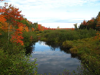
Gene Letourneau Wildlife Management Area is a 5241-acre Maine Wildlife Management Area (WMA) operated and managed by the Department of Inland Fisheries and Wildlife (IFW) located in the towns of Montville, Knox and part of Morrill in Waldo County, ME about 12 miles west of Belfast. Frye Mountain is a managed forested area with second-growth spruce and white pine. There are many reverting farm fields and old apple orchards coupled with many oaks with their acorns that complete the mixed habitat. “The variety offers a very nice opportunity, really quite a pleasant landscape for deer hunting,” says regional wildlife biologist Jim Connolly of the Maine Department of Inland Fisheries and Wildlife. That helps explain why Frye Mountain is a popular destination for Maine hunters.

Charles E. Wheeler Wildlife Management Area is a 625-acre (253 ha) brackish tidal marsh, nature preserve and hunting area owned by the state of Connecticut located in Devon (village), Milford, New Haven County, Connecticut.
References
- ↑ "Wildlife Management Areas: Lands: Wildlife: Fish & Wildlife: Maine Dept of Inland Fisheries and Wildlife". maine.gov. Retrieved 22 November 2017.