
The Baltic Sea is an arm of the Atlantic Ocean that is enclosed by Denmark, Estonia, Finland, Germany, Latvia, Lithuania, Poland, Russia, Sweden, and the North and Central European Plain.

The Main is the longest tributary of the Rhine. It rises as the White Main in the Fichtel Mountains of northeastern Bavaria and flows west through central Germany for 525 kilometres (326 mi) to meet the Rhine below Rüsselsheim, Hesse. The cities of Mainz and Wiesbaden are close to the confluence.

The Paleogene is a geologic period and system that spans 43 million years from the end of the Cretaceous Period 66 million years ago (Mya) to the beginning of the Neogene Period 23.03 Mya. It is the beginning of the Cenozoic Era of the present Phanerozoic Eon. The earlier term Tertiary Period was used to define the span of time now covered by the Paleogene Period and subsequent Neogene Period; despite no longer being recognized as a formal stratigraphic term, "Tertiary" still sometimes remains in informal use. Paleogene is often abbreviated "Pg".

The Rhine is one of the major European rivers. The river begins in the Swiss canton of Graubünden in the southeastern Swiss Alps. It forms part of the Swiss-Liechtenstein, Swiss-Austrian, and Swiss-German borders. After that the Rhine defines much of the Franco-German border, after which it flows in a mostly northerly direction through the German Rhineland. Finally in Germany, the Rhine turns into a predominantly westerly direction and flows into the Netherlands where it eventually empties into the North Sea. It drains an area of 9,973 sq km and its name derives from the Celtic Rēnos. There are also two German states named after the river, North Rhine-Westphalia and Rhineland-Palatinate.

The Tyrrhenian Sea is part of the Mediterranean Sea off the western coast of Italy. It is named for the Tyrrhenian people identified with the Etruscans of Italy.
Main-Taunus is a Kreis (district) in the middle of Hessen, Germany and is part of the Frankfurt/Rhine-Main Metropolitan Region as well as the Frankfurt urban area. Neighboring districts are Hochtaunuskreis, district-free Frankfurt, Groß-Gerau, district-free Wiesbaden, Rheingau-Taunus. It is the second most densely populated rural district in Germany.

Ingelheim, officially Ingelheim am Rhein, is a town in the Mainz-Bingen district in the Rhineland-Palatinate state of Germany. The town sprawls along the Rhine's left bank. It has been Mainz-Bingen's district seat since 1996.
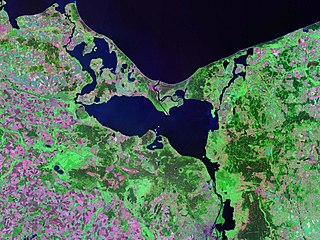
Szczecin Lagoon, also known as Oder Lagoon, and Pomeranian Lagoon, is a lagoon in the Oder estuary, shared by Germany and Poland. It is separated from the Pomeranian Bay of the Baltic Sea by the islands of Usedom and Wolin. The lagoon is subdivided into the Kleines Haff in the West and the Wielki Zalew in the East. An ambiguous historical German name was Frisches Haff, which later exclusively referred to the Vistula Lagoon.

Rhenish Hesse or Rhine Hesse is a region and a former government district in the German state of Rhineland-Palatinate. It is made up of territories west of the Upper Rhine river that were part of the Grand Duchy of Hesse and its successor in the Weimar Republic, the People's State of Hesse from 1816 to 1945. The hilly countryside is largely devoted to vineyards, comprising the Rheinhessen wine region.

Dorset is a county in South West England on the English Channel coast. Covering an area of 2,653 square kilometres (1,024 sq mi); it borders Devon to the west, Somerset to the north-west, Wiltshire to the north-east, and Hampshire to the east. The great variation in its landscape owes much to the underlying geology, which includes an almost unbroken sequence of rocks from 200 to 40 million years ago (Mya) and superficial deposits from 2 Mya to the present. In general, the oldest rocks appear in the far west of the county, with the most recent (Eocene) in the far east. Jurassic rocks also underlie the Blackmore Vale and comprise much of the coastal cliff in the west and south of the county; although younger Cretaceous rocks crown some of the highpoints in the west, they are mainly to be found in the centre and east of the county.
The geology of Hampshire in southern England broadly comprises a gently folded succession of sedimentary rocks dating from the Cretaceous and Palaeogene periods. The lower (early) Cretaceous rocks are sandstones and mudstones whilst those of the upper (late) Cretaceous are the various formations which comprise the Chalk Group and give rise to the county's downlands. Overlying these rocks are the less consolidated Palaeogene clays, sands, gravels and silts of the Lambeth, Thames and Bracklesham Groups which characterise the Hampshire Basin.

SMS Mainz was a Kolberg-class light cruiser of the German Kaiserliche Marine during the First World War. She had three sister ships, SMS Kolberg, Cöln, and Augsburg. She was built by the AG Vulcan shipyard in Stettin; her hull was laid down in 1908 and she was launched in January 1909. She was commissioned into the High Seas Fleet in October 1909. She was armed with a main battery of twelve 10.5 cm SK L/45 guns and had a top speed of 25.5 kn.

The London Basin is an elongated, roughly triangular sedimentary basin approximately 250 kilometres (160 mi) long which underlies London and a large area of south east England, south eastern East Anglia and the adjacent North Sea. The basin formed as a result of compressional tectonics related to the Alpine orogeny during the Palaeogene period and was mainly active between 40 and 60 million years ago.

The Hampshire Basin is a geological basin of Palaeogene age in southern England, underlying parts of Hampshire, the Isle of Wight, Dorset, and Sussex. Like the London Basin to the northeast, it is filled with sands and clays of Paleocene and younger ages and it is surrounded by a broken rim of chalk hills of Cretaceous age.
The Saxon Uplands, Saxon Hills or Ore Mountain Foreland is a strip of countryside of about 200 m to 500 m above sea level (NN) high, in the German state of Saxony, that lies immediately north of the German Ore Mountains and runs mainly through the areas of Zwickauer Land, Zwickau, Chemnitzer Land, Chemnitz, Mittelsachsen and the country south of Dresden. It borders on the Upper Pleißeland to the extreme west, the Ore Mountain Basin in the south and the Mulde Loess Hills to the north and east.
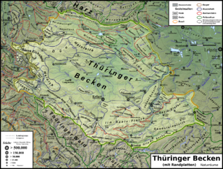
The Thuringian Basin is a depression in the central and northwest part of Thuringia in Germany which is crossed by several rivers, the longest of which is the Unstrut. It stretches about 60 kilometres (37 mi) from north to south and around 120 kilometres (75 mi) from east to west. Its height varies from about 150 to 250 m above sea level (NN).

The West Hesse Depression is part of the West Hesse Highlands and Lowlands region in the north of the German state of Hesse. Like the East Hesse Depression, it is a series of separate depressions that form a natural corridor and have been an important historical trade route.

The European Cenozoic Rift System (ECRIS) is a 1,100 km (680 mi) long system of rifts formed in the foreland of the Alps as the lithosphere responded to the effects of the Alpine and Pyrenean orogenies. The system began to form during the Late Eocene and parts remain seismically active today and are responsible for most of the larger earthquakes in Europe, north of the Alps.
The Montrose Group is a stratigraphic group, a set of geological rock strata of Paleocene age, found beneath the North Sea and locally onshore in southeastern England. It was originally described from offshore exploration wells in the North Sea. The Thanet Formation in the London Basin has more recently been assigned to the group.
The Mid-Labrador Ridge was a mid-ocean ridge in the Labrador Sea that represented a divergent boundary between the Greenland and North American plates during the Paleogene. The ridge extended from the South Greenland Triple Junction in the southeast to the Davis Strait area in the northwest. Seafloor spreading along the Mid-Labrador Ridge discontinued about 40 million years ago when the mid-ocean ridge became essentially extinct.