Majuhan

Last updated

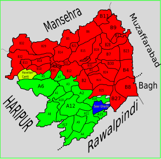
Majuhan is a village in Abbottabad District of Khyber-Pakhtunkhwa province of Pakistan. Until the local government reforms of 2000 it was a Union Council, an administrative subdivision of the district, [1] currently it is part of Nambal Union Council. [2]

Abbottabad District District in Khyber Pakhtunkhwa, Pakistan

Abbottabad District is a district of the Pakistani province of Khyber Pakhtunkhwa. It is part of Hazara Division and covers an area of 1,969 km2, with the city of Abbottabad being the principal town. Neighbouring districts are Mansehra to the north, Muzaffarabad to the east, Haripur to the west, and Rawalpindi to the south.

Khyber Pakhtunkhwa Province in Pakistan

Khyber Pakhtunkhwa, formerly known as North-West Frontier Province, is one of the four administrative provinces of Pakistan, located in the northwestern region of the country along the international border with Afghanistan. It was previously known as the North-West Frontier Province until 2010 when the name was changed to Khyber Pakhtunkhwa by the 18th Amendment to Pakistan's Constitution, and is known colloquially by various other names. Khyber Pakhtunkhwa is the third-largest province of Pakistan by the size of both population and economy, though it is geographically the smallest of four. Within Pakistan, Khyber Pakhtunkhwa shares a border with Punjab, Balochistan, Azad Kashmir, Gilgit-Baltistan, and Islamabad. It is home to 17.9% of Pakistan's total population, with the majority of the province's inhabitants being Pashtuns. The province is the site of the ancient kingdom Gandhara, including the ruins of its capital Pushkalavati near modern-day Charsadda. Originally a stronghold of Buddhism, the history of the region was characterized by frequent invasions under various Empires due to its geographical proximity to the Khyber Pass.

Pakistan federal parliamentary constitutional republic in South Asia

Pakistan, officially the Islamic Republic of Pakistan, is a country in South Asia. It is the world’s sixth-most populous country with a population exceeding 212,742,631 people. In area, it is the 33rd-largest country, spanning 881,913 square kilometres. Pakistan has a 1,046-kilometre (650-mile) coastline along the Arabian Sea and Gulf of Oman in the south and is bordered by India to the east, Afghanistan to the west, Iran to the southwest, and China in the far northeast. It is separated narrowly from Tajikistan by Afghanistan's Wakhan Corridor in the northwest, and also shares a maritime border with Oman.

Location

Marjuan is located in west of Abbottabad District, and lies near to the borders of Kashmir

Kashmir former princely state, now a conflict territory between India and Pakistan

Kashmir is the northernmost geographical region of the Indian subcontinent. Until the mid-19th century, the term "Kashmir" denoted only the Kashmir Valley between the Great Himalayas and the Pir Panjal Range. Today, it denotes a larger area that includes the Indian-administered territory of Jammu and Kashmir, the Pakistani-administered territories of Azad Kashmir and Gilgit-Baltistan, and Chinese-administered territories of Aksai Chin and the Trans-Karakoram Tract.

Related Research Articles

Sheikhul Bandi Union council in Khyber-Pakhtunkhwa, Pakistan

Sheikhul Bandi is one of the 51 union councils (sub-divisions) of Abbottabad District in Khyber-Pakhtunkhwa province of Pakistan. The Union council takes its name from a neighbourhood which is 3 km from the city of Abbottabad. It is in the valley toward the north-west of the Sarban Hills. It is located at 34° 8' 60N, 73° 13' 60E

Bal Dheri Union Council Union Council in Khyber Pakhtunkhwa, Pakistan

Bal Dheri is one of the 51 union councils of Abbottabad District in Khyber-Pakhtunkhwa province of Pakistan, the union council of Baldheri is named after the main village of the area. The population of Baldheri Union Council is 14,796.

Salhad Union Council Union council in Khyber Pakhtunkhwa, Pakistan

Salhad is one of the 51 union councils (sub-divisions) of Abbottabad District in the Khyber-Pakhtunkhwa province of Pakistan.

Seer Gharbi Union council in Khyber-Pakhtunkhwa, Pakistan

Seer Gharbi,سير غربي, is one of the 51 union councils of Abbottabad District in Khyber-Pakhtunkhwa province of Pakistan. It is located in the southeastern part of the province, bordering the Rawalpindi District of Punjab province.

Langra, Khyber Pakhtunkhwa Union council in Khyber Pakhtunkhwa, Pakistan

Langra is one of the 51 union councils of Abbottabad District in the Khyber Pakhtunkhwa province of Pakistan.

Chamhad Union Council Union Council in Khyber Pakhtunkhwa, Pakistan

Chamhad is one of the 51 Union Councils (subdivisions) of Abbottabad District in the Khyber Pakhtunkhwa province of Pakistan.

Birot Kalan Union Council Union Council in Khyber Pakhtunkhwa, Pakistan

Birot Kalan is one of the 51 union councils of Abbottabad District in the Khyber-Pakhtunkhwa province of Pakistan.

Ghari Phulgran Union council in Khyber-Pakhtunkhwa, Pakistan

Garhi Phulgran is one of the 51 union councils of Abbottabad District in Khyber-Pakhtunkhwa province of Pakistan.

Rahi is a village in the Union Council of Phallah, Abbottabad District, Khyber Pakhtunkhwa, Pakistan. It is located in the south west of the district.

Sarbhana Union council in Khyber-Pakhtunkhwa, Pakistan

Sarbhana is one of the 51 union councils of Abbottabad District in Khyber-Pakhtunkhwa province of Pakistan.

Pind Kargoo Khan Union Council Union council in Khyber-Pakhtunkhwa, Pakistan

Pind Kargoo Khan is one of the 51 union councils of Abbottabad District in Khyber-Pakhtunkhwa province of Pakistan. It is located 30 km from Abbottabad city.

Bagh Union Council Union Council in Khyber Pakhtunkhwa, Pakistan

Bagh is a union council of Abbottabad District in Khyber-Pakhtunkhwa province of Pakistan, it has two high schools GHS Bagh and GMS Kehial The main tribe of this area are the Jadun and the Dhund Abbasis.

Seer Sharqi Bhattian Union council in Khyber-Pakhtunkhwa, Pakistan

Seer Sharqi Bhattian is one of the 51 union councils of Abbottabad District in Khyber-Pakhtunkhwa province of Pakistan. It is located in the south of the district – to the south and east it borders Murree, it also borders the following union councils within Abbottabad District, to the north Seer Gharbi, and to the west is Nagri Totial.

Mojohan Union council in Khyber-Pakhtunkhwa, Pakistan

Mojohan is one of the 51 union councils of Abbottabad District in Khyber-Pakhtunkhwa province of Pakistan. It is located in the west of the district.

Mir Pur Union council in Khyber Pakhtunkhwa, Pakistan

Mir Pur is one of the 51 union councils of Abbottabad District in the Khyber Pakhtunkhwa Province of Pakistan. It is located at an altitude of 1251 metres and lies in the west of the district.The population of the union council Mirpur was 46,206 in the 2017 census. Now the government have established this union council into three village councils .These are VC1,VC2 and VC3. Majority of the residents of Mirpur are jadoon (pashtuns)

Kehal Urban Union council in Khyber-Pakhtunkhwa, Pakistan

Kehal Urban is one of the 51 union councils of Abbottabad District in Khyber-Pakhtunkhwa province of Pakistan. It is located in the west of the district. It is one of the beautiful Union Councils of the District Abbottabad. After Local Bodies Election its Local Body members are:

Malikpura Urban Union council in Khyber-Pakhtunkhwa, Pakistan

Malikpura Urban is one of the 51 union councils of Abbottabad District in Khyber-Pakhtunkhwa province of Pakistan. It is located in the west of the district.

Nawansher Urban Union council in Khyber-Pakhtunkhwa, Pakistan

Nawansher Urban is one of the 51 union councils of Abbottabad District in Khyber-Pakhtunkhwa province of Pakistan. It is located in the north of the district. It is one of the oldest settlements in Abbottabad district.

Haveliani Urban Union council in Khyber-Pakhtunkhwa, Pakistan

Haveliani Urban is one of the 51 union councils of Abbottabad District in Khyber-Pakhtunkhwa province of Pakistan. It is located in the west of the district.

Lassan Thakral is a village and union council of Mansehra District in Khyber-Pakhtunkhwa province of Pakistan. It is located in the south of Mansehra district where it borders Abbottabad District.

References

Coordinates: 34°12′30″N73°29′0″E / 34.20833°N 73.48333°E / 34.20833; 73.48333

Geographic coordinate system Coordinate system

A geographic coordinate system is a coordinate system that enables every location on Earth to be specified by a set of numbers, letters or symbols. The coordinates are often chosen such that one of the numbers represents a vertical position and two or three of the numbers represent a horizontal position; alternatively, a geographic position may be expressed in a combined three-dimensional Cartesian vector. A common choice of coordinates is latitude, longitude and elevation. To specify a location on a plane requires a map projection.