
Eastbourne is a prominent and well-to-do suburb of Lower Hutt, a part of Wellington, New Zealand. Lying languidly beside the sea, it is a popular local tourist destination via car from Petone or from ferry crossings from central Wellington. Eastbourne had a population of 4,665 people as of the 2013 New Zealand census. An outer suburb, it lies on the eastern shore of Wellington Harbour, five kilometres south of the main Lower Hutt urban area and directly across the harbour from the Miramar Peninsula in Wellington city. A narrow exposed coastal road connects it with the rest of Lower Hutt via the industrial suburb of Seaview. It is named for Eastbourne in England, another seaside town known for fanciness and day-trips.
The Kennett Bros is the business name for brothers Paul Kennett, Simon Kennett and Jonathan Kennett. They have been heavily involved in mountain biking in New Zealand since 1984, and in publishing books about cycling and cyclists. They were inducted into the Mountain Bike Hall of Fame in 2018.

The Department of Conservation (DOC) is the public service department of New Zealand charged with the conservation of New Zealand's natural and historical heritage.

Nelson Lakes National Park is located in the South Island of New Zealand.
The Tararua Range, often referred to as the Tararua Ranges or the Tararuas, is one of several mountain ranges in the North Island of New Zealand.

Zealandia, formerly known as the Karori Wildlife Sanctuary, is a protected natural area in Wellington, New Zealand, the first urban completely fenced ecosanctuary, where the biodiversity of 225 ha of forest is being restored. The sanctuary was previously part of the water catchment area for Wellington, between Wrights Hill and the Brooklyn wind turbine on Polhill.
Mount Kaukau, [] is a large hill in the northern suburbs of Wellington, New Zealand near Johnsonville, Khandallah and Ngaio. The summit is 445 metres above sea level and is the most visible high point in the Wellington landscape further accentuated by Wellington's main television transmitter mast, which stands 122m from the summit. The city, harbour and the Remutaka and Tararua Ranges can be seen from the summit. On a clear day Mt. Tapuae-o-Uenuku and the Kaikoura Ranges in the South Island may be seen, whilst northwest is the Porirua Basin and the Tasman Sea.

The Orongorongo River runs for 32 kilometres (20 mi) southwest through the Orongorongo Valley in the southern Remutaka Ranges of the North Island of New Zealand. The river and its associated catchments lie within the bounds of the Remutaka Forest Park, which is administered by the Department of Conservation.

Otari Native Botanic Garden and Wilton's Bush Reserve is the only public botanic garden in New Zealand dedicated solely to New Zealand native plants. It is located in Wellington's suburb of Wilton.

Bottle Lake Forest is a production forest and recreational park located in Christchurch, New Zealand, approximately 10 kilometres (6.2 mi) north-east of the city centre. It makes up the vast majority of the area of the suburb Bottle Lake. The visitor centre at the Forest's entry from Waitikiri Drive provides visitors with information about the different roles of Bottle Lake Forest. It also provides fresh water access, toilet facilities and parking.
Pūkaha National Wildlife Centre is a captive breeding facility and visitor centre located in a protected forest area on State Highway 2 in New Zealand's Tararua district.

Tāwharanui Peninsula is a finger of land projecting into the Hauraki Gulf from the east coast of the much larger North Auckland Peninsula of New Zealand. It separates Omaha Bay to the north from Kawau Bay and Kawau Island to the south. The nearest sizable town is Warkworth.
1080, the brand name given to the synthetic form of sodium fluoroacetate, is used in New Zealand in efforts to control populations of possums, rats, stoats, deer, and rabbits, which are invasive species in the New Zealand environment. Although the Parliamentary Commissioner for the Environment deemed the use of 1080 in New Zealand "effective and safe" in a 2011 re-evaluation and the substance is widely considered to be the most effective tool currently available for controlling possums over large areas, it remains a contentious issue, with the majority of the debate occurring between conservationists and livestock farmers on one side and hunters and animal-rights activists on the other. Concerns are also raised about the security of potable water supplies in areas where 1080 is applied.

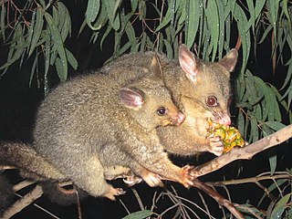
The common brushtail possum is a major agricultural and conservation pest in New Zealand.
Tararua Forest Park, often called the Tararuas is a protected area in the Wellington region of New Zealand. Its area is 1,150 square kilometres (440 sq mi), and its highest point, a peak called Mitre, is at 1571 m above sea level. It was established in 1954, as New Zealand's first Forest Park, and is managed by the Department of Conservation (DOC) under the Conservation Act. Tararua Forest Park includes more than three-quarters of the Tararua Range, and its boundaries extend north from New Zealand State Highway 2.

The Brook Waimārama Sanctuary is a nearly 700 hectare mainland “ecological island” sanctuary located 6 km south of Nelson, New Zealand. The Brook Waimārama Sanctuary Trust was established in 2004 with the intent of restoring the flora and fauna of the Brook Valley, a former water supply for Nelson with intact beech forest. A predator-proof fence was completed in 2016, introduced mammalian pests were poisoned in a controversial operation in 2017, and the sanctuary reopened to the public in 2018. Reintroductions of species such as the Okarito kiwi and saddleback are planned.
Wellington town belt and Outer green belt is a pair of strips of tree-filled wilderness spaces near and around central Wellington, New Zealand's capital city. The inner strip, the town belt, is an elongated U-shape. It was set aside by the city's founders in 1840. It is now about two-thirds of its original area. Portions have been used for purposes like Wellington's Public Hospital and Wellington Botanic Garden.
Melrose is a suburb of Wellington, New Zealand. It is south of the city centre, Berhampore and Newtown, and is in the Eastern Ward. Although adjacent to Lyall Bay, it does not have seafront access to the bay.

Goodnature is a New Zealand manufacturer of lethal traps for animals such as stoats, rats, mice and possums. It was founded by Robbie van Dam and Craig Bond in 2005, and sells automatic self-resetting pest control traps and accessories.
The Mākara Beach locality, previously spelled Makara Beach, is a suburb of Wellington, New Zealand. The Wellington City Council regards it as a separate suburb to Mākara.


