India is the most populous country in the world with one-sixth of the world's population. According to UN estimates, India overtook China in having the largest population in the world with a population of 1,425,775,850 at the end of April 2023.

Shajapur District is a district of Madhya Pradesh state of central India. The town of Shajapur is the district headquarters.

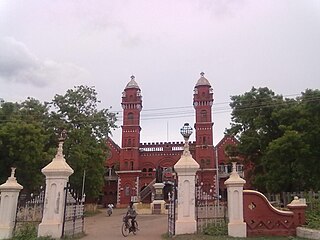
Pudukkottai District is one of the 38 districts of Tamil Nadu state in southern India. The city of Pudukkottai is the district headquarters. It is also known colloquially as Pudhugai.
Bhota is a town and a nagar panchayat in Hamirpur district in the state of Himachal Pradesh, India. It is also a village situated in District Hamirpur, Himachal Pradesh, its geographical coordinates are 32° 46' 0" North, 74° 1' 0" East and its original name is Bhota.
Vijalpor is a city and a municipality in Navsari district in the Indian state of Gujarat. The city is under Surat Metropolitan Region. The town is located at a distance of 7 km south of Navsari City off Udhana-Nasik Highway.
North West Delhi is an administrative district of the National Capital Territory of Delhi in India.

Thiruvarur district is one of the 38 districts in the Tamil Nadu state of India. As of 2011, the district had a population of 1,264,277 with a sex-ratio of 1,017 females for every 1,000 males.

Fatehgarh Sahib district is one of the twenty-three districts of the state of Punjab, India, with its headquarters in the town of Fatehgarh Sahib.

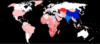
The human sex ratio is the ratio of males to females in a population in the context of anthropology and demography. In humans, the natural sex ratio at birth is slightly biased towards the male sex. It is estimated to be about 1.05 or 1.06 or within a narrow range from 1.03 to 1.06 males per female.

Alirajpur is one of the 52 districts of Madhya Pradesh state in India. It was created from Alirajpur, Jobat and Bhabra tehsils of the former Jhabua district on 17 May 2008. It is the least literate district in India as per Census 2011. Alirajpur is the administrative headquarters of the district. The district occupies an area of 2,165.24 square kilometres (836.00 sq mi), and at the 2011 census had a population of 728,999. It includes the city of Alirajpur.
The child sex ratio in India is defined as the number of females per thousand males in the age group 0–6 years in a human population. Thus it is equal to 1000 x the reciprocal of the sex ratio in the same age group, i.e. under age seven. An imbalance in this age group will extend to older age groups in future years. Currently, the ratio of males to females is generally significantly greater than 1, i.e. there are more boys than girls.

Sangrur district is in the state of Punjab in northern India. Sangrur city is the district headquarters. It is one of the five districts in Patiala Division in the Indian state of Punjab. Neighbouring districts are Malerkotla (north), Barnala (west), Patiala (east), Mansa (southwest) and Fatehabad (Haryana) and Jind (Haryana) (south).
Katamalli is a village in Belgaum district in Karnataka, India.
Kutaranatti is a village in Belgaum district in Karnataka, India.

Khed taluka is a taluka in the subdivision, near Pune city in Pune district of the state of Maharashtra in India. Rajgurunagar is the headquarter of the taluka. The taluka is known for being the birthplace of Santaji Jagnade.The name of city is rajgurunagar on the name of Shaheed Shivram Hari Rajguru.

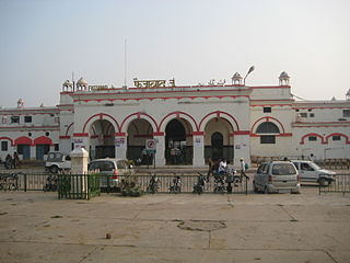
Faizabad Junction railway station, officially known as Ayodhya Cantt railway station, is a railway station in Uttar Pradesh, India. It is located on the Lucknow-Varanasi section and is a part of the Northern Railway zone. Faizabad Junction and Ayodhya Junction are the two railway junction stations in Ayodhya district.
Female foeticide in India is the abortion of a female foetus outside of legal methods. A research by Pew Research Center based on Union government data indicates foeticide of at least 9 million females in the years 2000–2019. The research found that 86.7% of these foeticides were by Hindus, followed by Sikhs with 4.9%, and Muslims with 6.6%. The research also indicated an overall decline in preference for sons in the time period.
Bapatla mandal is one of the 25 mandals in Bapatla district of the state of Andhra Pradesh, India. It is under the administration of Bapatla revenue division and the headquarters are located at Bapatla. The mandal is bounded by Kakumanu, Ponnur, Karlapalem mandals of Guntur district. It also shares borders with Prakasam district and a portion of it lies on the coast of Bay of Bengal.

Pulla is a village in Eluru district of the Indian state of Andhra Pradesh. It is situated in Bhimadole mandal of Eluru revenue division.
T. Narasapuram Mandal is one of the 28 mandals in Eluru district of the Indian state of Andhra Pradesh. The headquarters are located in T. Narasapuram town. The mandal is bordered by Jangareddygudem Mandal and Jeelugumilli to the north, Kamavarapukota Mandal to the east, Chintalapudi Mandal to the south and Khammam district to the west.


