Lekir is one of main village and a new village in Manjung district, Perak, Malaysia. Sufian Shukor is the Penghulu Mukim of Lekir. Pantai Tanjung Kepah is small fisherman's beach in the village.
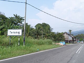
Terong is a mukim in Larut, Matang and Selama District, Perak, Malaysia. It is famous for the quality of its water and the presence of a waterfall. Tin was also mined there until 1980. It had Malay, Chinese and Tamil primary schools but the numbers have dwindled considerably.

Mileševo is a village in Serbia. It is situated in the Bečej municipality, South Bačka District, Vojvodina province. The village has a Hungarian ethnic majority and its population numbering 1,118 people.

Poiana Lacului is a commune in Argeș County, Romania. It is composed of thirteen villages: Cătunași, Cepari, Dealu Orașului, Dealu Viilor, Dinculești, Gălețeanu, Gărdinești, Gâlcești, Metofu, Păduroiu din Deal, Păduroiu din Vale, Poiana Lacului and Sămara.
Grivița is a commune located in Ialomița County, Romania. It is composed of two villages, Griviţa and Smirna.
Bucovăț is a commune in Dolj County, Romania with a population of 4,224 people. It is composed of seven villages: Bucovăț, Cârligei, Italieni, Leamna de Jos, Leamna de Sus, Palilula and Sărbătoarea.
Fărcaș is a commune in Dolj County, Romania with a population of 3,590 people. It is composed of five villages: Amărăști, Fărcaș, Golumbelu, Golumbu and Plopu-Amărăști. It included five other villages until 2004, when they were split off to form Tălpaș Commune.
Ișalnița is a commune in Dolj County, Romania with a population of 3,922 people. It is composed of a single village, Ișalnița.
Răcari is a town located in Dâmbovița County, Romania. It administers seven villages: Bălănești, Colacu, Ghergani, Ghimpați, Mavrodin, Săbiești and Stănești. It was declared a town in 2004.

Dobruchów is a village in the administrative district of Gmina Wodzierady, within Łask County, Łódź Voivodeship, in central Poland. It lies approximately 4 kilometres (2 mi) north-west of Wodzierady, 17 km (11 mi) north of Łask, and 26 km (16 mi) west of the regional capital Łódź.
Sobocka Wieś is a village in the administrative district of Gmina Bielawy, within Łowicz County, Łódź Voivodeship, in central Poland. It lies approximately 14 kilometres (9 mi) west of Łowicz and 40 km (25 mi) north-east of the regional capital Łódź.
Vulturești is a commune in Olt County, Romania. It is composed of four villages: Dienci, Valea lui Alb, Vlăngărești and Vulturești.
Wola Palczewska is a village in the administrative district of Gmina Warka, within Grójec County, Masovian Voivodeship, in east-central Poland. It lies approximately 13 kilometres (8 mi) south-west of Warka, 19 km (12 mi) south-east of Grójec, and 54 km (34 mi) south of Warsaw.
Brzeziny-Kolonia is a village in the administrative district of Gmina Poczesna, within Częstochowa County, Silesian Voivodeship, in southern Poland. It lies approximately 3 kilometres (2 mi) north-west of Poczesna, 8 km (5 mi) south of Częstochowa, and 55 km (34 mi) north of the regional capital Katowice.

Nam Mẫu is a commune (xã) and village in Ba Bể District, Bắc Kạn Province, in Vietnam.
Kotenčice is a village and municipality in Příbram District in the Central Bohemian Region of the Czech Republic.
Kao, Niger is a village and rural commune in Niger.
Neitla is a village in Järva Parish, Järva County in northern-central Estonia.
Veliki Šenj is a village in the municipality of Stragari, Serbia. According to the 2002 census, the village has a population of 350 people.
Rayasandra is a village in the Tumkur district of Karnataka, India. It is located in the Dandinashivara hobli, Turuvekere taluk of Tumkur district in Karnataka. The village belongs to Machenahalli grampanchayat, has around 80-100 houses, the speaking language is Kannada. The village has mainly two communities Lingayat and Adi Karnataka.


