The Tasman Sea is a marginal sea of the South Pacific Ocean, situated between Australia and New Zealand. It measures about 2,000 kilometres (1,200 mi) across and about 2,800 kilometres (1,700 mi) from north to south. The sea was named after the Dutch explorer Abel Janszoon Tasman, who was the first recorded European to encounter New Zealand and Tasmania. The British explorer Captain James Cook later extensively navigated the Tasman Sea in the 1770s as part of his first voyage of exploration.

Peel River, a watercourse that is part of the Namoi catchment within the Murray–Darling basin, is located in the North West Slopes and Plains district of New South Wales, Australia.

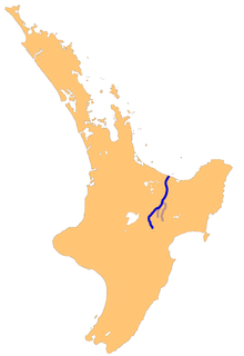
The Rangitikei River is one of New Zealand's longest rivers, 185 kilometres (115 mi) long.
The Rangitaiki River is the longest river in the Bay of Plenty region in New Zealand's North Island. It is 155 kilometres (96 mi) long, and rises inland from northern Hawkes Bay to the east of the Kaingaroa Forest.

The Mercury Islands are a group of seven islands off the northeast coast of New Zealand's North Island. They are located 8 kilometres (5 mi) off the coast of the Coromandel Peninsula, and 35 kilometres (22 mi) northeast of the town of Whitianga.
The Turakina River is a river of the southwestern North Island of New Zealand. It flows generally southwestward from its source south of Waiouru, roughly paralleling the larger Whangaehu River, and reaches the sea 20 kilometres (12 mi) southeast of Wanganui.

Bączałka is a village in the administrative district of Gmina Brzostek, within Dębica County, Subcarpathian Voivodeship, in south-eastern Poland. It lies approximately 16 kilometres (10 mi) south of Dębica and 40 km (25 mi) west of the regional capital Rzeszów.
Grudna Górna is a village in the administrative district of Gmina Brzostek, within Dębica County, Subcarpathian Voivodeship, in south-eastern Poland. It lies approximately 7 kilometres (4 mi) north-east of Brzostek, 16 km (10 mi) south of Dębica, and 40 km (25 mi) west of the regional capital Rzeszów.
The Manaia River is a river of the Coromandel Peninsula in New Zealand's North Island. It flows north from its sources in the Coromandel Range, reaching the waters of the Hauraki Gulf at Manaia Harbour, 10 kilometres (6 mi) southwest of Coromandel.
The Moawhango River is a major river of the centre of New Zealand's North Island. It flows generally southwest from its sources in the Kaimanawa Range 35 kilometres (22 mi) east of Mount Ruapehu to reach Lake Moawhango at the southern end of the Rangipo Desert, 10 kilometres (6 mi) north of Waiouru. Some water is diverted from the lake for the Tongariro Power Scheme, while some is released to continue down the Moawhango River. From here, the river flows southeast, passing the small settlement of Moawhango before its outflow into the Rangitikei River 8 kilometres (5 mi) southeast of Taihape.
The Oterei River is a river of the southern Wairarapa, in the Wellington Region of New Zealand's North Island. It flows initially northwest before turning south to reach Cook Strait 30 kilometres (19 mi) northeast of Cape Palliser.

The Poulter River is a river of the Canterbury Region of New Zealand's South Island. The Poulter rises on the southern slopes of Mount Koeti in Arthur's Pass National Park, flowing predominantly southwest to reach the Waimakariri River 15 kilometres (9 mi) east of Cass.
The Rangiora River is a river of the Wellington Region of the North Island of New Zealand. It is a tributary of the Waikanae River, which it joins 5 kilometres (3 mi) southeast of Waikanae.
The Tokomaru River is a river of the Manawatu-Wanganui Region of New Zealand's North Island. It rises to the southeast of Shannon and initially flows northeast down a long valley in the Tararua Range before turning northwestto reach the edge of the Manawatu Plain near the town of Tokomaru. From here it turns southwest, reaching the Manawatu River 3 kilometres (2 mi) north of Shannon.
The Waiotauru River is a river of the Wellington Region of New Zealand's North Island. It flows generally north from two branches, the Southern Waiotauru River and the Eastern Waiotauru River. Both of these branches have their origins in the southwestern Tararua Range, with the Eastern branch having its origin on the slopes of Mount Hector. The Waiotauru meets the Otaki River at Otaki Forks, 15 kilometres (9 mi) southeast of Otaki.
The Waitewaewae River is a river of the Wellington Region of New Zealand's North Island. An upper tributary of the Otaki River, it flows south through Tararua Forest Park to reach the Otaki 20 kilometres (12 mi) east of Waikanae.
The Ohau River is a river of the Horowhenua District of New Zealand's North Island. It flows from the confluence of two short rivers, the North Ohau River and the South Ohau River. The Ohau initially flows north, turning west to the southeast of Levin. It reaches the Tasman Sea 10 kilometres (6 mi) southwest of Levin.
The Mangaone River is a river of the Manawatu-Wanganui Region of New Zealand's North Island. Rising on the slopes of Mount Baker, it flows north and northeast to meet the Tiraumea River 2 kilometres (1.2 mi) south of the settlement of Kaitawa
The northern Tiraumea River is a river of the Manawatu-Wanganui Region of New Zealand's North Island. The river rises in the rough hill country of the Tararua District, just south of the settlement of Tiraumea. A tributary, Tiraumea Stream, drains the southern end of the Puketoi Range. The river flows west then north to reach the Manawatu River immediately above the highway and Rail bridges, 5 kilometres (3 mi) south of Woodville.

Pipiriki is a settlement in New Zealand, on the east bank of the Whanganui River, due west of the town of Raetihi and 79 kilometres (49 mi) upriver from Whanganui; it was originally on the opposite bank. It is the home of Ngāti Kura, a hapū of the Ngāti Ruanui iwi. It is also the location of the Paraweka Marae of the hapū Ngāti Kurawhatia of the iwi Te Āti Haunui-a-Pāpārangi.