
The Luapula River is a section of Africa's second-longest river, the Congo. It is a transnational river forming for nearly all its length part of the border between Zambia and the DR Congo. It joins Lake Bangweulu to Lake Mweru and gives its name to the Luapula Province of Zambia.

The Colo River, a perennial stream that is part of the Hawkesbury-Nepean catchment, is located in the Central Tablelands of New South Wales, Australia.

Ahr is a river in Germany, a left tributary of the Rhine. Its source is at an elevation of approximately 470 metres (1,540 ft) above sea level in Blankenheim in the Eifel, in the cellar of a timber-frame house near the castle of Blankenheim. After 18 kilometres (11 mi) it crosses from North Rhine-Westphalia into Rhineland-Palatinate.

The Whau River is an estuarial arm of the southwestern Waitemata Harbour within the Auckland metropolitan area in New Zealand. It flows north for 5.7 kilometres (3.5 mi) from its origin at the confluence of the Avondale Stream and Whau Stream to its mouth between the Te Atatū peninsula and the long, thin Rosebank Peninsula in Avondale. It is 800 metres (2,600 ft) at its widest and 400 metres (1,300 ft) wide at its mouth.

The Durance is a major river in south-eastern France. A left tributary of the Rhône, it is 323.2 km (200.8 mi) long. Its drainage basin is 14,472 km2 (5,588 sq mi).

The Mareb River, or Gash River is a river flowing out of central Eritrea. Its chief importance is defining part of the boundary between Eritrea and Ethiopia, between the point where the Mai Ambassa enters the river at 14°53.6′N37°54.8′E to the confluence of the Balasa with the Mareb at 14°38′N39°1.3′E.

The Huon River is a perennial river located in the south-west and south-east regions of Tasmania, Australia. At 174 kilometres (108 mi) in length, the Huon River is the fifth-longest in the state, with its course flowing east through the fertile Huon Valley and emptying into the D'Entrecasteaux Channel, before flowing into the Tasman Sea.

The Holme of the Holme Valley, West Yorkshire, England is a tributary of the River Colne, West Yorkshire. The source is via Digley Reservoir, fed firstly by the run-off from Brownhill Reservoir, then by Dobbs Dike. Banks along the upper valley are mostly urbanised and are in the Holme Valley civil parish.

The Upper Nepean Scheme is a series of dams and weirs in the catchments of the Cataract, Cordeaux, Avon and Nepean rivers of New South Wales, Australia. The scheme includes four dams and two weirs, and a gravity-fed canal system that feeds into a large storage reservoir to provide water to the Macarthur and Illawarra regions, the Wollondilly Shire, and metropolitan Sydney. The four dams and associated infrastructure are individually listed on the New South Wales State Heritage Register.

Goodradigbee River, a perennial stream that is part of the Murrumbidgee catchment within the Murray–Darling basin, is located in the Snowy Mountains district of New South Wales, Australia.
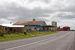
Douglas is a lowly populated locality and a rural centre in east Taranaki, surrounded by dairy, sheep and beef pastoral farming. It is situated 18 km east of Stratford at the intersection of East Road, Ohura Road, Douglas Road South and Bredow Road. East Road and Ohura Road meet to form State Highway 43, linking Stratford to the King Country town of Taumarunui. The Stratford–Okahukura Line, a secondary railway line, runs through Douglas where it veers north-east and away from the state highway for approximately 20 km.
Toko is a small rural settlement 10 kilometres east of Stratford, New Zealand, at the intersection of East Road and Toko Road. It is located on a railway, the Stratford–Okahukura Line, the western portion of which was operated as a branch line known as the Toko Branch prior to the line's completion. The Toko Stream flows through the area to join the Patea River.

Tututawa is a locality and rural centre in east Taranaki, New Zealand, 26 kilometres (16 mi) east of Stratford, with a population of approximately 40. The settlement is centred 5 kilometres (3.1 mi) south of Ohura Road, at the intersection of Mangaotuku Road and Tututawa Road. Positioned approximately 150 metres (490 ft) above sea level, Tututawa is nestled in a valley amongst high sandstone and greywacke ridgelines. Within the area are the historic localities of Tewheniwheni, Mangaehu and Tawhiwhi.
The Waitotara River in New Zealand's North Island stretches approximately 100 km in length from its headwaters in the Matemateāonga Range to its mouth on the South Taranaki Bight. The river takes in significant tributaries such as the Ngutuwera, Makakaho, Pokeka, Omaru and Totara Streams.
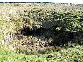
Langcliffe Pot is a cave system on the slopes of Great Whernside in Upper Wharfedale, about 3 kilometres (1.9 mi) SSE of Kettlewell in North Yorkshire. It is part of the Black Keld Site of Special Scientific Interest where the "underground drainage system which feeds the stream resurgence at Black Keld is one of the largest and deepest in Britain, although only a small proportion of its cave passages are accessible at present." Mossdale Caverns is also part of the Black Keld SSSI. Although a considerable length of passage has been explored in Langcliffe Pot, the current end is over 170 metres (560 ft) above the resurgence, and over 4 kilometres (2.5 mi) in distance. A trip to the far end has been described as "one of the most serious undertakings in British Caving".

The Tangahoe River is a river of the Taranaki Region of New Zealand's North Island. It flows generally southwest from its origins in hill country to the east of Lake Rotorangi, reaching the Tasman Sea in the South Taranaki Bight 5 km (3.1 mi) southeast of Hawera.

Stratford District is a territorial authority district in the North Island of New Zealand. The Stratford District Council is headquartered in the only town, Stratford. The district is divided between the Manawatū-Whanganui region and the Taranaki region.

The Buckland River, a perennial river of the North-East Murray catchment of the Murray-Darling basin, is located in the alpine region of Victoria, Australia. It flows from the eastern slopes of the Buffalo Range in the Australian Alps, joining with the Ovens River at Porepunkah.

Rivelin Dams are a pair of water storage reservoirs situated in the upper part of the Rivelin Valley, 5 miles (8 km) west of Sheffield in South Yorkshire, England. The dams are owned by Yorkshire Water and provide water to 319,000 people as well as compensation water for the River Rivelin. They are named Upper and Lower and fall just within the eastern boundary of the Peak District.

The Sebnitz is the left, larger headstream of the Lachsbach and runs through both the Czech Republic as well as the German Free State of Saxony. The upper section in the Czech Republic is known as Vilémovský potok in Czech and Wölmsdorfer Bach in German.