
Box Elder County is a county at the northwestern corner of Utah, United States. At the 2020 census, the population was 57,666, up from the 2010 figure of 49,975. Its county seat and largest city is Brigham City. The county was named for the box elder trees that abound in the county.

Juab County is a county in western Utah, United States. As of the 2020 United States Census, the population was 11,786. Its county seat and largest city is Nephi.

Millard County is a county in the U.S. state of Utah. As of the 2020 United States Census, the population was 12,975. Its county seat is Fillmore, and the largest city is Delta.

Tooele County is a county in the U.S. state of Utah. As of the 2020 United States Census, the population was 72,698. Its county seat and largest city is Tooele. The county was created in 1850 and organized the following year.

Weber County is a county in the U.S. state of Utah. As of the 2020 census, the population was 262,223, making it Utah's fourth-most populous county. Its county seat and largest city is Ogden, the home of Weber State University. The county was named for the Weber River.

Oneida County is a county located in the U.S. state of Idaho. As of the 2020 Census the county had a population of 4,564. The county seat and largest city is Malad City. Most of the county's population lives in Malad City and the surrounding Malad Valley.
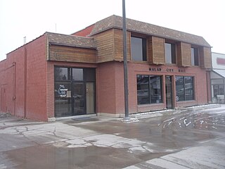
Malad City is the only city in Oneida County, Idaho, United States. Its population was 2,095 at the 2010 census, down from 2,158 in 2000.

Beaver is a city in, and county seat of, Beaver County in southwestern Utah, United States. The population was 3,592 at the 2020 census, up from the 2010 figure of 3,112.

Tremonton is a city in Box Elder County, Utah. The population was 7,647 at the time of the 2010 census.

Fillmore is a city and the county seat of Millard County, Utah, United States. The population was 2,592 at the 2020 United States Census. It is named for the thirteenth U.S. President Millard Fillmore, who was in office when Millard County was created by the Utah Territorial legislature.

The State of Deseret was a proposed state of the United States, proposed in 1849 by settlers from the Church of Jesus Christ of Latter-day Saints in Salt Lake City. The provisional state existed for slightly over two years, but was never recognized by the United States government. The name derives from the word for "honeybee" in the Book of Mormon.

The Territory of Utah was an organized incorporated territory of the United States that existed from September 9, 1850, until January 4, 1896, when the final extent of the territory was admitted to the Union as the State of Utah, the 45th state. At its creation, the Territory of Utah included all of the present-day State of Utah, most of the present-day state of Nevada save for Southern Nevada, much of present-day western Colorado, and the extreme southwest corner of present-day Wyoming.
The Utah Territorial Statehouse, officially Territorial Statehouse State Park Museum, is a state park in Fillmore, Utah, preserving the original seat of government for the Utah Territory. Built from 1852 to 1855, the statehouse was initially intended as a larger structure, but only the south wing was completed before the project was abandoned due to lack of federal funding, and the Utah Territorial Legislature met in the building only once before the capital was moved to Salt Lake City in 1856.

Interstate 84 (I-84) is a part of the Interstate Highway System that links Portland, Oregon, to I-80 near Echo, Utah. The 117.38-mile-long (188.90 km) segment in the US state of Utah is the shortest of any of the three states the western I-84 passes through and contains the eastern terminus of the highway. I-84 enters Box Elder County near Snowville before becoming concurrent with I-15 in Tremonton. The concurrent highways travel south through Brigham City and Ogden and separate near Ogden-Hinckley Airport. Turing east along the Davis County border, I-84 intersects US Route 89 (US-89) and enters Weber Canyon as well as Morgan County. While in Morgan County, I-84 passes the Devil's Gate-Weber Hydroelectric Power Plant and Devil's Slide rock formation. Past Morgan, the highway crosses into Summit County, past the Thousand Mile Tree before reaching its eastern terminus at I-80 near Echo.

The Salt Lake City metropolitan area is the metropolitan area centered on the city of Salt Lake City, Utah. The Office of Management and Budget and the United States Census Bureau currently define the Salt Lake City, Utah Metropolitan Statistical Area as comprising two counties: Salt Lake and Tooele. As of the 2020 census, the MSA had a population of 1,257,936. The Salt Lake City Metropolitan Area and the Ogden-Clearfield Metropolitan Area were a single metropolitan area known as the Salt Lake City-Ogden Metropolitan Area until being separated in 2005.

Washakie is a ghost town in far northern Box Elder County, Utah, United States. Lying some 3 miles (4.8 km) southeast of Portage, it was established in 1880 by the Church of Jesus Christ of Latter-day Saints for the settlement of the Northwestern Shoshone. The Washakie Indian Farm was home to the main body of this Native American band through most of the 20th century. By the mid-1970s, Washakie's residents were gone and the property sold to a private ranching operation. Today the tribal reservation consists of a small tract containing the Washakie cemetery, and the tribe is seeking to acquire more of the surrounding land. The old LDS chapel in Washakie is now on the National Register of Historic Places.

When Desert County, Utah Territory was created March 3, 1852 it extended into present-day Nevada from the shore of the Great Salt Lake on the east to the western edge of the Great Basin in California between Weber and Tooele counties in Utah Territory.
